Unmanned airship low-altitude photogrammetry

An unmanned airship and photogrammetry technology, applied in the field of surveying and mapping science, can solve the problems of inability to carry out small-scale measurement, high measurement cost, and insufficient flexibility, and achieve the effects of high mobility, high safety, and strong flexibility

Inactive Publication Date: 2010-07-21
王建雄
View PDF0 Cites 22 Cited by
  • Summary
  • Abstract
  • Description
  • Claims
  • Application Information

AI Technical Summary

Problems solved by technology

[0003] The invention provides a low-altitude photogrammetry method for an unmanned airship, which is beneficial to overcome the shortcomings of traditional photogrammetry such as high cost, s

Method used


Image

  • Unmanned airship low-altitude photogrammetry
  • Unmanned airship low-altitude photogrammetry

Examples


Embodiment Construction

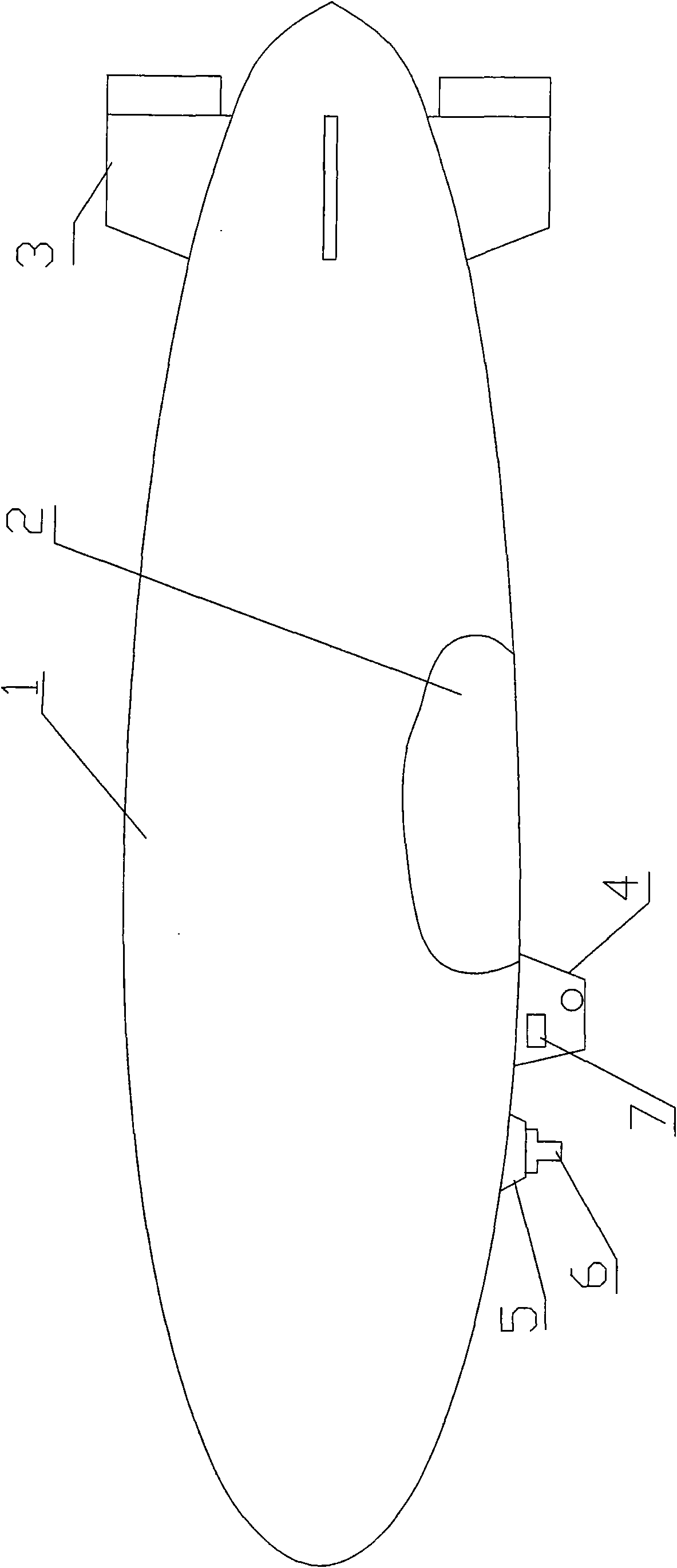
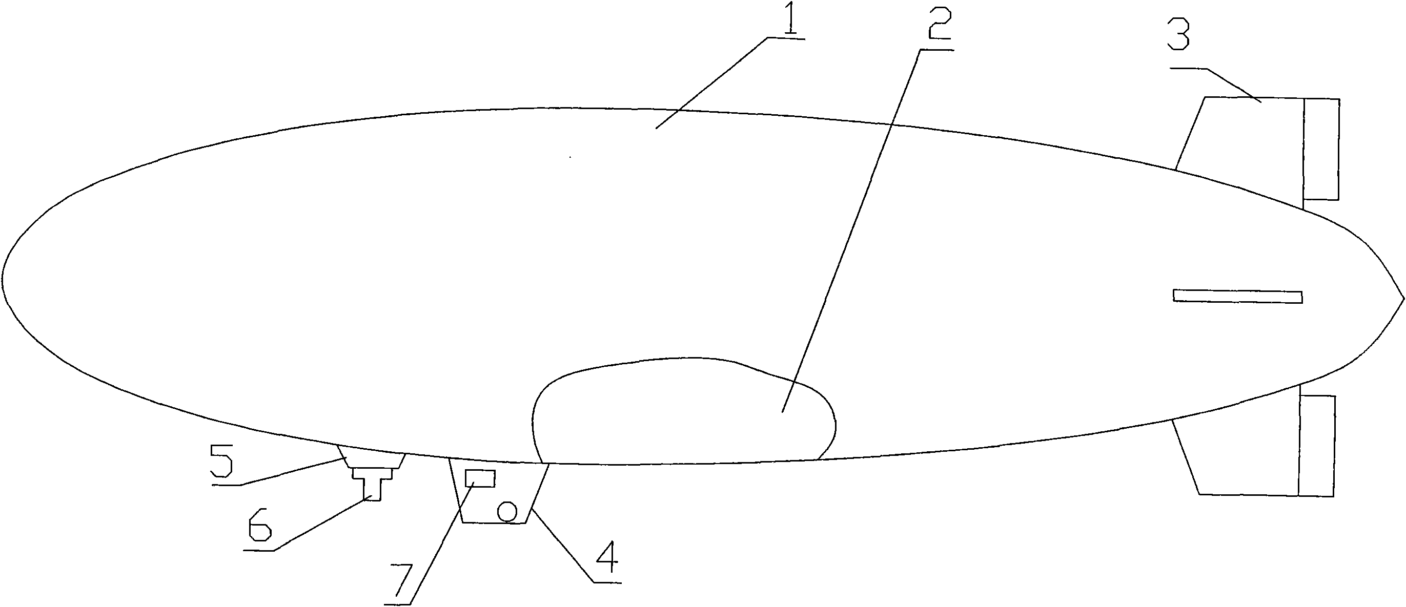
[0009] The present invention comprises the unmanned airship that is made up of main airbag 1, secondary airbag 2, tail rudder 3, engine pod 4, and flight controller 7, three-axis stabilized platform 5 and digital camera 6 and forms.

[0010] According to the actual situation of the measurement area, the route planning is carried out first, and the flight route, route interval, photo interval, and flight altitude are pre-calculated, and the data is transmitted to the flight controller and stored; after the unmanned airship takes off by remote control, it is controlled by the flight controller. According to the different flying heights, adjust the ratio of the main airbag and the auxiliary airbag according to the common operation method in this field to adapt to different flying height requirements; according to the volume ratio, the main airbag is filled with 90% to 100% helium or hydrogen, and the auxiliary airbag Fill with 10% to 0% air. According to the route set in advance,...


PUM


Abstract

The invention relates to an unmanned airship low-altitude photogrammetry, which comprises an unmanned airship consisting of a main air bag, a vice air bag, a stern rudder and an engine car, a flight controller, a three-axis stabilized holder and a digital camera, wherein the vice air bag fixed in the main air bag is arranged according to the volume with certain proportion and can be adjusted. According to the practical situation of a measurement region, an airline plan is firstly made, the flight path, the strip interval, the photographing interval and the flight altitude are calculated in advance, and the data is transmitted to and stored by the flight controller; the unmanned airship is controlled by the flight controller after taking off by remote control, and the flight controller controls the stern rudder and the engine to operate the airship to fly according to the pre-determined airline and speed; in flight, the flight controller controls the digital camera fixed on the three-axis stabilized holder to take photos over the ground according to specified distance and/or time intervals; and compared with the conventional photogrammetry, the invention has the characteristics of high mobility, low cost and high security, and is suitable for mapping large scale topographical maps of medium and small areas.

Description

Technical field: [0001] The invention belongs to the field of surveying and mapping science and technology, in particular to a low-altitude photogrammetry device and method based on an unmanned airship. Background technique: [0002] With the development of surveying and mapping science and technology and the national economy, resource and ecological environment investigation, detection and evaluation, e-government, digital city and major engineering construction all require realistic and high-precision topographic map data. How to quickly and accurately obtain and update basic data has always been a long-term concern of the national infrastructure department. If low-altitude photogrammetry below 500 meters can be realized, it can completely get rid of the influence of cloud cover and satisfy the surveying and mapping of large-scale topographic maps of 1:2000 to 1:500 in small and medium areas. Invention content: [0003] The invention provides a low-altitude photogrammet...

Claims


Application Information

Patent Timeline
IPC IPC(8): G01C11/00B64B1/58
Inventor 王建雄崔建军陈向宁
Owner 王建雄
Why Eureka
Try Eureka