Fault-tolerance autonomous navigation method of multi-sensor of high-altitude long-endurance unmanned plane

A multi-sensor, autonomous navigation technology, applied in directions such as integrated navigators, can solve the problems affecting aircraft navigation accuracy, GPS signals are susceptible to electromagnetic interference, error accumulation, etc., and achieve the effect of facilitating system reconstruction

Inactive Publication Date: 2010-10-13
NANJING UNIV OF AERONAUTICS & ASTRONAUTICS
View PDF3 Cites 52 Cited by
  • Summary
  • Abstract
  • Description
  • Claims
  • Application Information

AI Technical Summary

Problems solved by technology

However, GPS signals are susceptible to electromagnetic interference, which leads to a decrease in INS / GPS positioning accuracy; and GPS is affiliated to the United States. Once a war occurs, GPS signals will be completely lost. At this time, only INS plays a role in the INS / GPS integrated navigation system, and the error will be large. Continuously accumulate, affecting the navigation accuracy of the aircraft
[0005] Therefore, the existing aviation airborne inertial / GPS combined autonomous navigation method has low reliability and unstable navigation accuracy, and cannot fully meet the requirements of high-altitude and long-haul UAVs for navigation accuracy stability.

Method used


Image

  • Fault-tolerance autonomous navigation method of multi-sensor of high-altitude long-endurance unmanned plane
  • Fault-tolerance autonomous navigation method of multi-sensor of high-altitude long-endurance unmanned plane
  • Fault-tolerance autonomous navigation method of multi-sensor of high-altitude long-endurance unmanned plane

Examples


Embodiment Construction

[0026] Below in conjunction with accompanying drawing, the technical scheme of invention is described in detail:

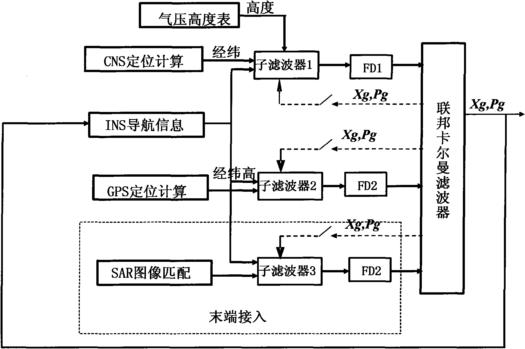
[0027] Such as figure 1 Shown, the principle of the present invention is: from the angle of airborne geographic system navigation, set up the position linearization measurement equation under the geographic system, including GPS / INS measurement equation, CNS / barometric altimeter / INS measurement equation and SAR / INS measurement equations. The specific implementation method is as follows:

[0028] 1. Establish the error state quantity equation of the aviation airborne inertial navigation system

[0029] Select the navigation coordinate system as the Northeast Heaven Geographical Horizontal Coordinate System (O n x n Y n Z n ), combined with a linear Kalman filter, the state equation of the system is the error state quantity equation of the inertial navigation system, through the analysis of the performance and error sources of the inertial navigation system, t...


PUM


Abstract

The invention discloses a fault-tolerance autonomous navigation method of a multi-sensor of a high-altitude long-endurance unmanned plane. The method comprises the following steps of: firstly, carrying out theory analysis on work environment and work characteristics of three navigation sensors including GPS (Global Position System), CNS (astronomy) and SAR (Synthetic Aperture Radar), and establishing an observation linearity measurement equation by combining a geography system based on a position combined observation principle of inertia / GPS, inertia / astronomy and inertia / SAR under an airborne geography system; then analyzing error characteristics of a navigation sensor and simulating the output during the fault of GPS, and establishing a corresponding fault detection algorithm unit to carry out fault detection and isolation on a filter; and finally, designing and completing an inertia / GPS combined navigation system mathematic model based on the assistance of astronomy and SAR, and optimally evaluating the error state of the inertia navigation by means of federated filtering. The invention has high navigation precision, and can fully play the role of evaluating the error state quantity of an airborne inertia navigation system by the combined navigation of the multi-sensor under the geography system.

Description

technical field [0001] The invention relates to a multi-sensor fault-tolerant autonomous navigation method for high-altitude and long-term unmanned aerial vehicles, which belongs to the technical field of integrated navigation of aviation aircraft, and can be applied to the determination of navigation parameters of aircraft for high-altitude and long-term flight, and is suitable for high-altitude and long-term flight Navigation and positioning of aviation aircraft. Background technique [0002] As a high-precision astronomical attitude sensor, the star sensor is more and more widely used in the field of autonomous navigation. The star sensor can directly and accurately measure the attitude information of the aircraft relative to the inertial coordinate system without any external reference information, and its measurement accuracy remains stable throughout the navigation process. The existing highest accuracy can reach the arc-second level. The inertial / astronomical integra...

Claims


Application Information

Patent Timeline
Patent Type & Authority Applications(China)
IPC IPC(8): G01C21/24
Inventor 陈海明熊智王丹王融刘建业于永军郁丰张丹陈计辉
Owner NANJING UNIV OF AERONAUTICS & ASTRONAUTICS
Why Eureka
Try Eureka