Intelligent hypercompact combination navigation method of vehicle-mounted GPS software-based receiver

An ultra-tight integrated navigation and software receiver technology, which is applied in satellite radio beacon positioning systems, measuring devices, instruments, etc., can solve the problems of being unable to intelligently adapt to environmental changes, etc., and achieve enhanced anti-jamming capabilities and wide navigation coverage , the effect of excellent precision

Inactive Publication Date: 2010-10-13
SOUTHEAST UNIV
View PDF3 Cites 29 Cited by
  • Summary
  • Abstract
  • Description
  • Claims
  • Application Information

AI Technical Summary

Problems solved by technology

[0005] However, the current integrated navigation system algorithms all use a single system to assist another system in the same mode, which cannot intelligently adapt to environmental changes
Looking at my country's vehicle-mo

Method used


Image

  • Intelligent hypercompact combination navigation method of vehicle-mounted GPS software-based receiver
  • Intelligent hypercompact combination navigation method of vehicle-mounted GPS software-based receiver
  • Intelligent hypercompact combination navigation method of vehicle-mounted GPS software-based receiver

Examples


Embodiment Construction

[0030] Below in conjunction with accompanying drawing, the technical scheme of invention is described in detail:

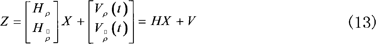
[0031] Such as figure 1 As shown, the present invention is based on the software GPS receiver / low-cost inertial ultra-tight working mode, according to different environmental autonomous reconstruction combination methods, and makes full use of limited navigation data to realize high-precision, high-reliability vehicle-mounted seamless positioning. The specific steps are as follows :

[0032] (1) Receive satellite signals and analyze and generate GPS navigation data

[0033] Through the GPS software receiver, the signal carrier-to-noise ratio, the number of visible stars, I, Q information, pseudo-range and pseudo-range rate information and speed and position information are obtained;

[0034] (2) Collect and analyze inertial navigation data

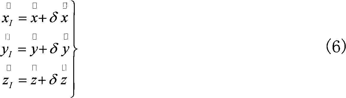
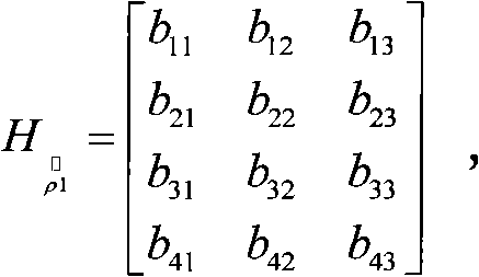
[0035] Through the inertial navigation unit, the speed and position information of the carrier is obtained, and the pseud...


PUM


Abstract

The invention discloses an intelligent hypercompact combination navigation method of a vehicle-mounted GPS software-based receiver, which carries out switching of the intelligent navigation work mode, self-adaptive matching of multi-source system, filter and intelligent navigation positioning against for the hypercompact combination mode of a software GPS (global satellite positioning system) receiver/low cost MINS (Micro Inertia Navigation System). Whether in the high dynamic environment or in the weak satellite signal environment, the method can adequately utilize the information obtained by the subsystems, can intelligently allocate the main system, the auxiliary system and the combination form thereof, can instantly correct and compensate the error, and can effectively realize the vehicle-mounted seamless positioning of the urban traffic.

Description

technical field [0001] The present invention is applicable to the navigation and positioning technical fields with medium and low precision requirements such as urban traffic, navigation, etc., in order to meet the navigation and positioning requirements of high precision, high reliability and large positioning coverage, and to study its relationship with low-precision positioning on the basis of GPS software receivers The intelligent ultra-tight integrated navigation technology of the cost inertial sensor realizes the seamless positioning of the vehicle in environments such as weak satellite signals and high dynamics. Background technique [0002] Inertial navigation is an autonomous navigation system that does not depend on any external information and does not radiate energy outward. It has the advantages of good maneuverability, strong environmental adaptability, and high short-term accuracy. However, because the error of the inertial navigation system accumulates over t...

Claims


Application Information

Patent Timeline
IPC IPC(8): G01S19/39G01S19/47
Inventor 陈熙源虞婧祝雪芬赵月芳方琳
Owner SOUTHEAST UNIV
Why Eureka
Try Eureka