Building elevation positioning control and precision evaluation method based on satellite images

A technology for accuracy evaluation and positioning control, applied in surveying and navigation, photogrammetry/video metrology, measuring devices, etc., to achieve the effect of promoting application

Inactive Publication Date: 2010-12-01
TONGJI UNIV
View PDF2 Cites 21 Cited by
  • Summary
  • Abstract
  • Description
  • Claims
  • Application Information

AI Technical Summary

Problems solved by technology

[0024] In order to solve the deficiencies of existing high-resolution satellite image geometric positioning technology in densely built areas, the purpose of the present invention is to provide a method for building elevation positioning control and accu

Method used


Image

  • Building elevation positioning control and precision evaluation method based on satellite images
  • Building elevation positioning control and precision evaluation method based on satellite images
  • Building elevation positioning control and precision evaluation method based on satellite images

Examples


Embodiment Construction

[0044] The present invention will be further described below in conjunction with the embodiments shown in the accompanying drawings.

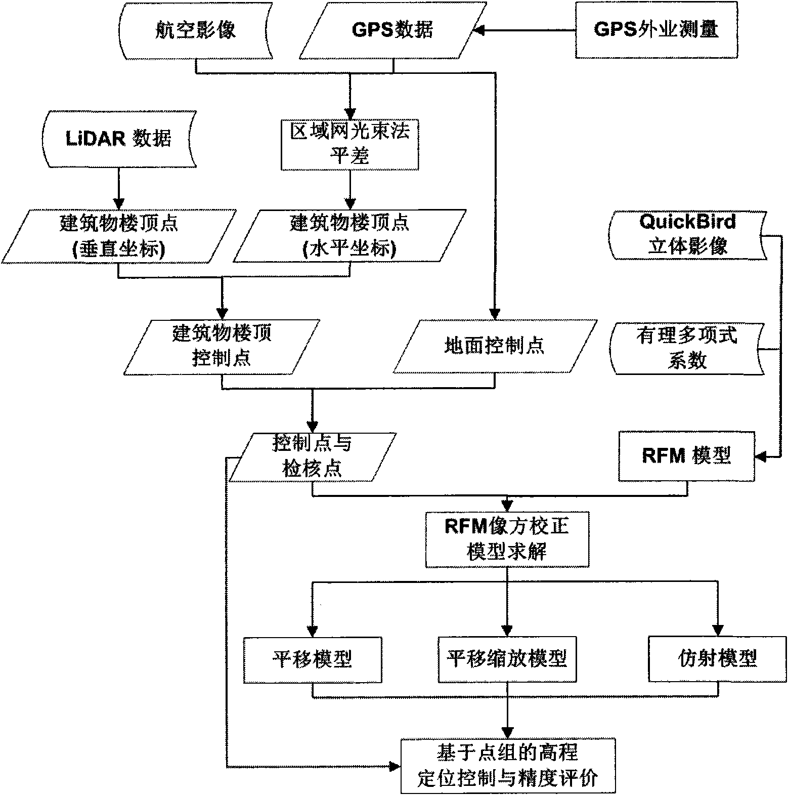
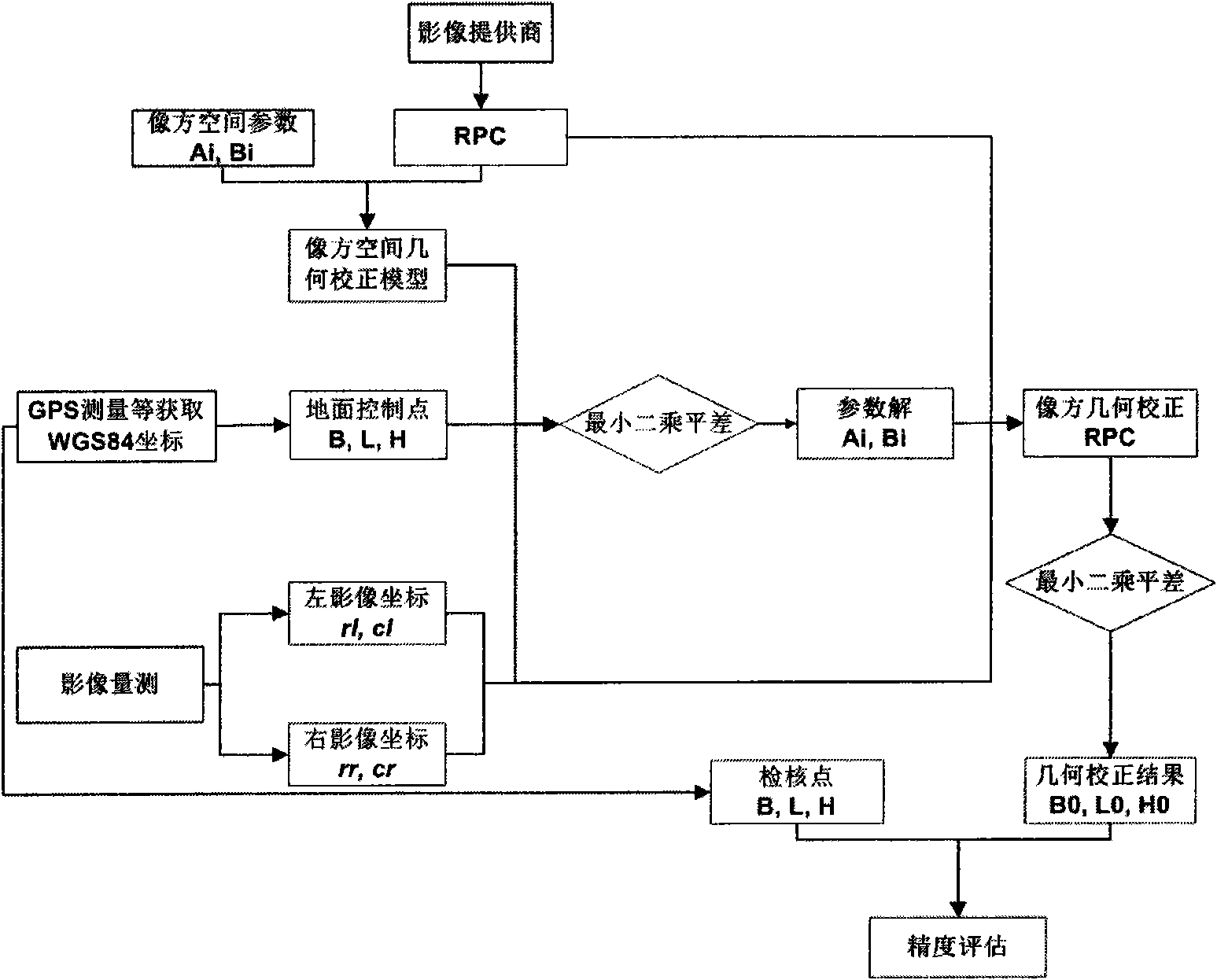
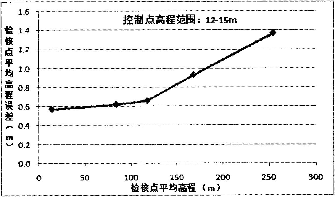
[0045] See attached figure 1 , the present invention adopts GPS field measurement to obtain the coordinates of the ground control points, and performs regional network beam adjustment on the aerial image to obtain the horizontal coordinates of the apex of the building, and integrates the vertical coordinates of the apex of the building obtained from the LiDAR data to obtain the building For the control information of building vertices, the image square RFM geometric correction model is used to geometrically locate high-resolution satellite stereo images, and a point group-based building elevation positioning control and accuracy evaluation scheme is proposed to obtain the relationship between the control point elevation and the check point group elevation accuracy. relationship between.

[0046] The present invention comprises the following st...


PUM


Abstract

The invention relates to a building elevation positioning control and precision evaluation method based on satellite images, belonging to the fields of acquisition and updating of urban spatial data of satellite three-dimensional remote sensing data. The method comprises the following concrete steps: (1) carrying out the field survey by a GPS to acquire ground control point data; (2) carrying out block bundle adjustment on aerial images to acquire building roof coordinates; (3) integrating the acquired horizontal coordinate with the building roof vertical coordinate acquired by airborne LiDAR data to acquire a building roof control point; (4) geometrically positioning high-resolution satellite three-dimensional images based on a rational function model (RFM) in an image space to acquire three-dimensional coordinates of the ground and the building roof; and (5) acquiring the relation between the elevation of the control point and the elevation precision of the point pattern of a check point by adopting the building elevation positioning control and precision evaluation scheme based on the point pattern. The invention can promote the application of high-resolution satellite three-dimensional remote sensing images in the fields of acquisition and updating of urban spatial data.

Description

technical field [0001] The invention belongs to the application field of satellite stereoscopic remote sensing data urban space data acquisition and update, and relates to a method for building elevation positioning control and accuracy evaluation based on satellite images, in particular to a high-resolution satellite stereoscopic image building based on multi-source remote sensing data Object elevation positioning control and accuracy evaluation method. Background technique [0002] High-resolution satellite images are currently one of the most important sources of spatial information in the field of earth observation. Research on all aspects of high-resolution satellite images has become a research hotspot in related fields, and high-precision geometric positioning is the key to high-resolution The basis and key of various applications of satellite imagery, its research has achieved certain results so far. At present, the widely used rational function model RFM has achiev...

Claims


Application Information

Patent Timeline
IPC IPC(8): G01C11/00
Inventor 乔刚王卫安李荣兴欧建良李元博王伟
Owner TONGJI UNIV
Why Eureka
Try Eureka