Three-dimensional spatial data adaptive pre-scheduling method based on spatial relationship

A technology of three-dimensional space and spatial relationship, applied in special data processing applications, electrical digital data processing, instruments, etc., can solve the problem of transferring three-dimensional spatial data into memory, etc., to avoid network congestion, solve system resource contention and use efficiency Effect

Active Publication Date: 2012-07-18
CHINA UNIV OF GEOSCIENCES (WUHAN)
View PDF0 Cites 0 Cited by
  • Summary
  • Abstract
  • Description
  • Claims
  • Application Information

AI Technical Summary

Problems solved by technology

[0002] Real-time visualization of 3D spatial data and multi-user online applications require extremely fast response time, which poses a huge challenge to the performance of large-scale 3D spatial data database management
Limited by the current computer hardware, it is impossible to transfer all the required 3D space data into the memory at one time when drawing the 3D scene, and the required data must be dynamically transferred according to the needs of the current 3D scene

Method used


Image

  • Three-dimensional spatial data adaptive pre-scheduling method based on spatial relationship
  • Three-dimensional spatial data adaptive pre-scheduling method based on spatial relationship
  • Three-dimensional spatial data adaptive pre-scheduling method based on spatial relationship

Examples


Embodiment Construction

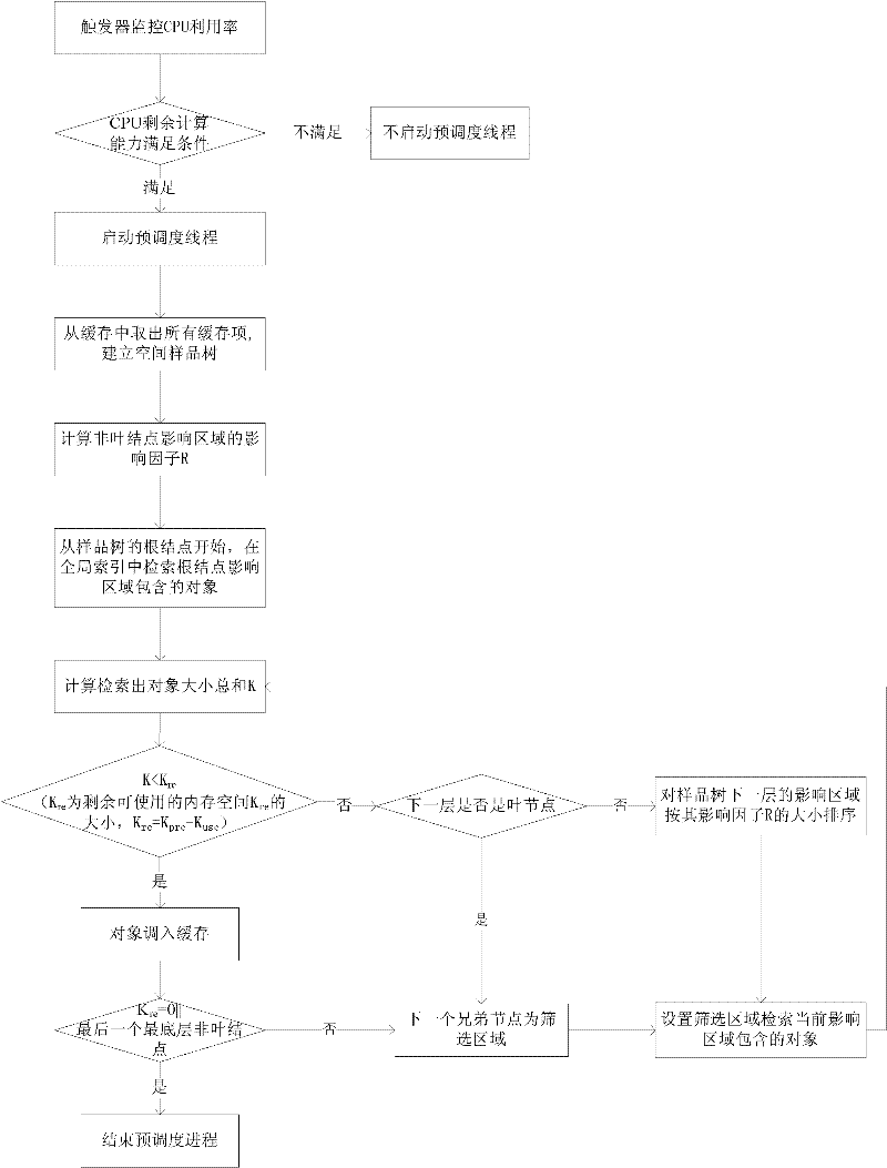
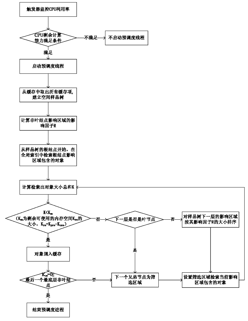
[0027] The self-adaptive pre-scheduling method for three-dimensional spatial data based on spatial relationships provided by the present invention comprehensively considers the range and importance of scheduled spatial objects, selects the optimal pre-scheduled object, and uses the pre-scheduling strategy based on spatial cluster analysis according to hardware such as memory Situation self-adaptive adjustment sets the pre-scheduling memory space, automatically finds the pre-scheduling object that meets the conditions, and according to the computing power of the CPU, starts and closes the pre-scheduling program in good time. The present invention will be further described below with specific embodiments in conjunction with the accompanying drawings:

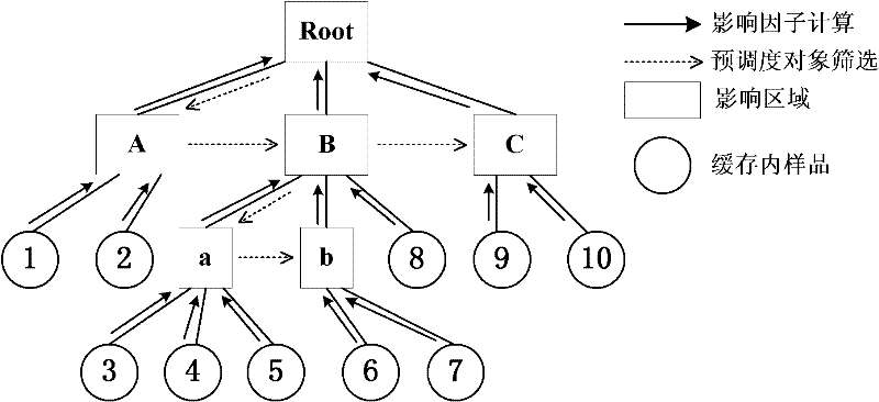
[0028] This method is based on the nine-intersection model in the spatial relationship, adopts the ideas of spatial clustering and spatial interpolation, regards the spatial objects in the cache as sample data, and establishes a sam...


PUM


Abstract

The invention relates to the technical field of geography and geoscience spatial information processing, in particular to a three-dimensional spatial data adaptive pre-scheduling method based on spatial relationship. In the method, a nine-intersection model in the spatial relationship is taken as the theoretical basis, the characteristics of cache management and spatial indexing are combined, theideas of spatial clustering and spatial interpolation are adopted, the spatial objects in the cache are taken as the sample data, the hit rate of the objects is taken as the estimative weight, the spatial object information in the spatial index is taken as the data to be estimated and simultaneously the memory capacity of the system and the computing capability of the CPU are taken into account. The pre-scheduling method can improve the scheduling speed of the spatial data. Tree index, trigger and multithreading technology are adopted, therefore, the method effectively solves the problems of system resource plunder and use efficiency and can remarkably improve the problem of data communication blocking. The algorithm can adapt to the scheduling requirement of the three-dimensional spatialdata, can be further used for multi-dimensional spatial data and can be popularized and used in various professional GIS software.

Description

technical field [0001] The invention relates to the technical field of geography and geoscience spatial information processing, in particular to an adaptive pre-scheduling method for three-dimensional spatial data based on spatial relationships. Background technique [0002] Real-time visualization of 3D spatial data and multi-user online applications require extremely fast response time, which poses a huge challenge to the performance of large-scale 3D spatial data database management. Due to the limitations of current computer hardware, it is impossible to transfer all the required three-dimensional space data into the memory at one time when drawing the three-dimensional scene, and the required data must be dynamically transferred according to the needs of the current three-dimensional scene. Therefore, whether the required data can be efficiently and dynamically dispatched from files or 3D spatial databases to the system memory has become the key to ensure the fluency of...

Claims


Application Information

Patent Timeline
Patent Type & Authority Patents(China)
IPC IPC(8): G06F17/30
Inventor WU CHONGLONGLIU GANGHE ZHENWENWENG ZHENGPINGWANG PINQIANSUN KATIAN YIPINGZHANG XIALINLIU JUNQILI XINCHUANLIU YUANYUANYANG CHENGJIEWEI ZHENHUAZHOU QING
Owner CHINA UNIV OF GEOSCIENCES (WUHAN)
Why Eureka
Try Eureka