Laser probing and image identification based terrain tracking method for unmanned helicopter

An unmanned helicopter and laser detection technology, which is applied to measuring devices, measuring distances, aircraft parts, etc., can solve problems such as heavy weight and expensive laser radar, and achieve the effects of less weight gain, simple structure, and easy modification

Inactive Publication Date: 2011-02-09
TSINGHUA UNIV
View PDF5 Cites 30 Cited by
  • Summary
  • Abstract
  • Description
  • Claims
  • Application Information

AI Technical Summary

Problems solved by technology

However, lidar is expensive and heavy and not the best choi...

Method used


Image

  • Laser probing and image identification based terrain tracking method for unmanned helicopter
  • Laser probing and image identification based terrain tracking method for unmanned helicopter

Examples


Embodiment Construction

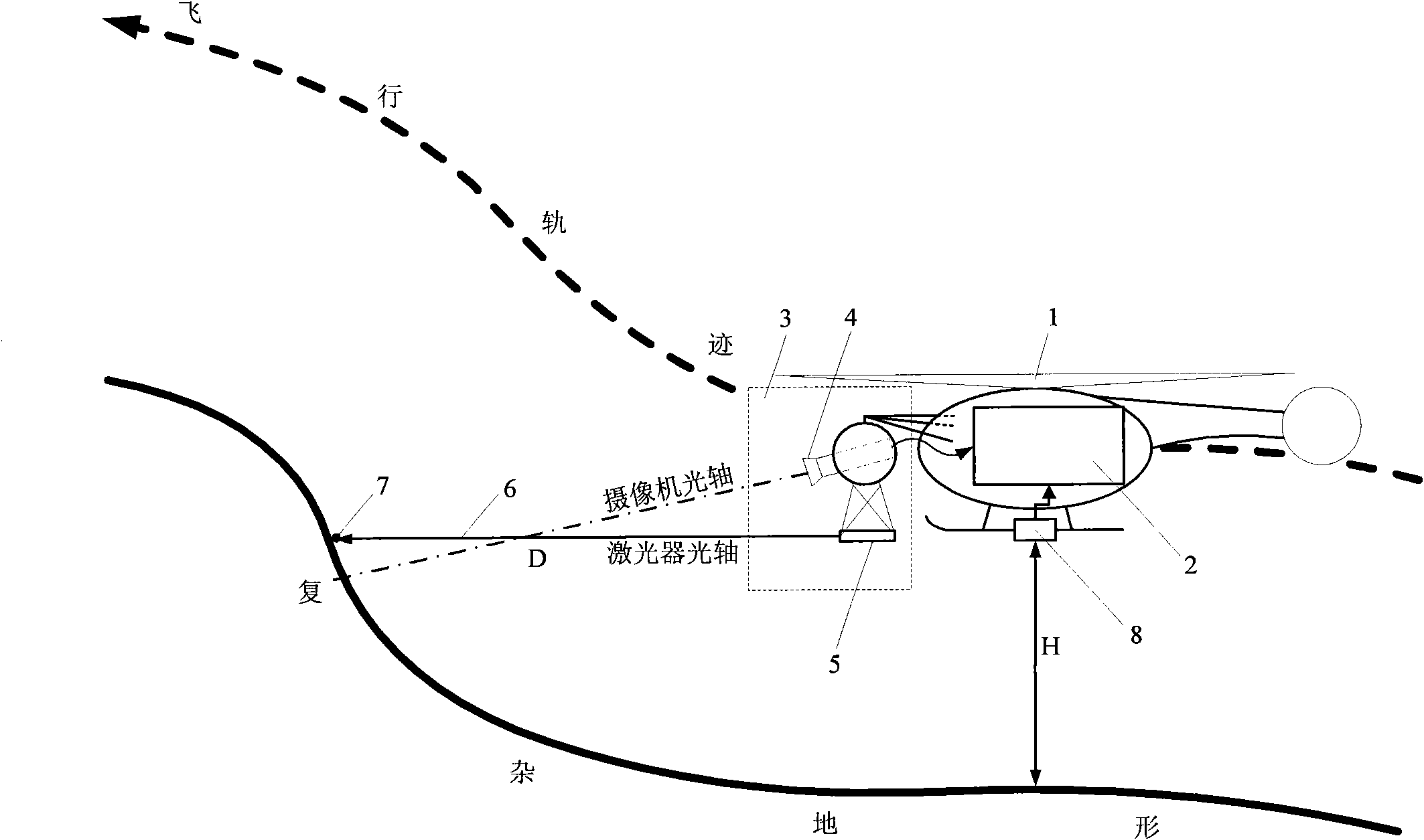
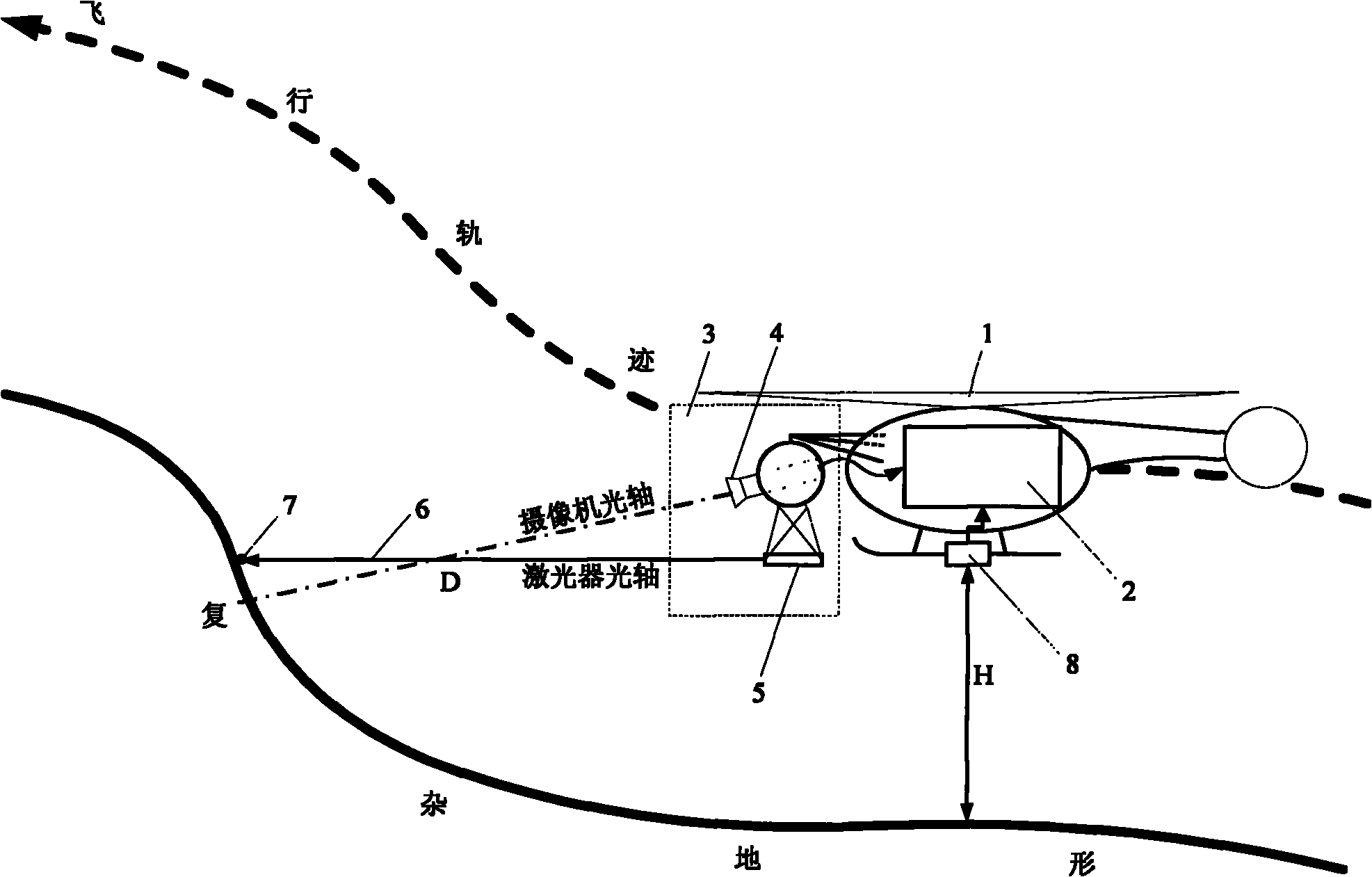
[0010] The unmanned helicopter terrain tracking method based on laser detection and image recognition is composed of a distance measuring sensor (3), a height sensor (8) and a flight control computer (2) based on laser detection and image recognition. Wherein, the ranging sensor (3) based on laser detection and image recognition is composed of an airborne camera (4) and a laser emitter (5).

[0011] The laser transmitter (5) irradiates the laser light (6) to the front of the unmanned helicopter (1). When the laser light (6) irradiates an obstacle in front, a laser spot (7) will be generated thereon. The on-board camera (4) captures the laser spot (7), and sends the video to the flight control computer (2). The flight control computer (2) can calculate the distance D between the unmanned helicopter (1) and the obstacle in front according to the position of the light spot in the video. The flight control computer (2) can learn the current height H of the unmanned helicopter (1...


PUM


Abstract

The invention relates to a laser probing and image identification based terrain tracking method for an unmanned helicopter, which belongs to the technical field of flight control of unmanned helicopters. The method is characterized in that a distance measurement sensor based on laser probing and image identification, an altimetric sensor and a flight control computer are provided, wherein the distance measurement sensor and the altimetric sensor are respectively used for measuring the distance D from the unmanned helicopter to a barrier and the terrain clearance H as well as a set distance Dc from the barrier and the terrain clearance Hc. The forward speed and the vertical speed (mainly the vertical speed) of the unmanned helicopter are adjusted by the flight control computer so that the unmanned helicopter maintains the set distance Dc from the barrier and the terrain clearance Hc unchanged approximately, thereby real-time tracking flight of the unmanned helicopter to complicated terrain is realized. In the invention, the unmanned helicopter can realize the terrain tracking function precisely, simply and reliably only by being provided with a few hardware devices.

Description

technical field [0001] The invention is a method for terrain tracking of an unmanned helicopter, which can realize the terrain tracking flight of the unmanned helicopter with high precision. It is mainly used in technical fields such as aerospace, drones and robots. Background technique [0002] Terrain following flight is one of the important maneuvering functions of helicopters, the main purpose is to avoid enemy detection and improve its own survivability. Traditional terrain-following flights are mostly completed with the assistance of terrain-following radars. Due to the heavy weight of terrain following radar, small unmanned helicopters are difficult to equip. Therefore, unmanned helicopters usually use lidar. However, lidar is expensive and heavy, and it is not the best choice for unmanned helicopters, especially small unmanned helicopters. [0003] Because ordinary unmanned helicopters usually have onboard cameras, altitude sensors and flight control computers. ...

Claims


Application Information

Patent Timeline
IPC IPC(8): G01C5/00B64D45/00G01C3/00
Inventor 王冠林朱纪洪
Owner TSINGHUA UNIV
Why Eureka
Try Eureka