Geographic information indexing system and information retrieval method

A technology of geographic information and indexing system, applied in the field of electronic map, can solve the problems of high maintenance cost, poor user interaction, high production and update cost, and achieve the effect of low production cost, high accuracy and easy acquisition.

Inactive Publication Date: 2011-04-06
SHENZHEN INSTITUTE OF INFORMATION TECHNOLOGY +1
View PDF5 Cites 12 Cited by
  • Summary
  • Abstract
  • Description
  • Claims
  • Application Information

AI Technical Summary

Problems solved by technology

[0004] The traditional geographical information platform uses vector graphics as the base map, which is fast in execution speed and convenient for query, but the display effect is not intuitive; GoogleEarth proposes an information platform based on remote sensing images, which is intuitive and vivid, but the user interaction is poor. Pictures cannot be divided and operated, and attribute connections can be established; the 3D maps of E City, Chachaba and other service platforms are intuitive and can be operated interactively, but the production and update costs are high, and maintenance costs are high, which is not conducive to high accuracy and fast update. Use in small communities and campuses

Method used


Image

  • Geographic information indexing system and information retrieval method
  • Geographic information indexing system and information retrieval method
  • Geographic information indexing system and information retrieval method

Examples


Embodiment Construction

[0019] The present invention will be further described below in conjunction with the accompanying drawings and specific embodiments.

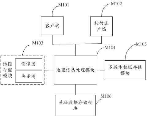
[0020] Such as figure 1 Shown is a schematic diagram of the overall structure of the electronic geographic information indexing system of the present invention. The system includes a client M101, a target client M102, a map storage module M103, a geographic information processing module M104, a multimedia data storage module M105, and an associated data storage module M106. The map storage module M103 is composed of image maps and vector graphics.

[0021] On the one hand, the geographic information processing module M104 generates an overlapping electronic map by calling the image map and the vector map, and the electronic map is transmitted to each client M101 and target client M102 through a local area network or a wide area network. The target client M102 can mark and update information on the position representing itself in real time, and...


PUM


Abstract

The invention provides a geographic information indexing system and an information retrieval method. The system comprises a user side map storage module, and the map storage module consists of an image map and a corresponding vector map; and the coordinate information of the vector map is acquired through click position information of the image map or the position information of the image map is acquired according to the coordinate information of the vector map. The method is a retrieval method for retrieving geographic information according to the corresponding relationship between the image map and the vector map. The method is easy to acquire the image map, has the advantages of timely update, high accuracy and low manufacturing cost, and overcomes the defects that the single image map causes poor user interactivity and attribute connection cannot be established between the maps. The time-following real-time update query provided by the system brings convenience to searching of the impending event information according to the query mark of the current time or a certain time point for a user.

Description

technical field [0001] The invention relates to the field of electronic maps, in particular to a system and an information retrieval method for expressing geographic information by overlapping high-altitude image maps and vector graphics. Background technique [0002] With the rapid development of the world's high-tech fields, especially the technology related to social informatization has made great breakthroughs, which has accelerated the process of global informatization. Digitization and informatization have become the trend and trend of high-tech development at home and abroad. Concepts such as digital earth, digital city and digital university have been gradually proposed and put into practice by some scholars. [0003] At present, there are relatively mature digital city 3D visualization modeling software products abroad, such as Multi-Gen Creator, Equipe, etc. ESRI's remote sensing image processing software ERDAS has also expanded its functions in this regard. "Digi...

Claims


Application Information

Patent Timeline
Patent Type & Authority Applications(China)
IPC IPC(8): G06F17/30
Inventor 湛邵斌高月芳张焕梅蓝志顶何晨
Owner SHENZHEN INSTITUTE OF INFORMATION TECHNOLOGY
Why Eureka
Try Eureka