Navigation path planning method, system and terminal

A navigation path and navigation terminal technology, applied to road network navigators and other directions, can solve problems such as delays in normal travel, incorrect navigation routes, etc., and achieve the effect of reducing work pressure

Inactive Publication Date: 2011-04-20
TECHTOTOP MICROELECTRONICS
View PDF2 Cites 14 Cited by
  • Summary
  • Abstract
  • Description
  • Claims
  • Application Information

AI Technical Summary

Problems solved by technology

[0005] The purpose of the present invention is to solve the problem that the current car navigation system and terminal cannot plan reasonable navi

Method used


Image

  • Navigation path planning method, system and terminal
  • Navigation path planning method, system and terminal
  • Navigation path planning method, system and terminal

Examples


Embodiment Construction

[0022] In order to make the object, technical solution and advantages of the present invention clearer, the present invention will be further described in detail below in conjunction with the accompanying drawings and embodiments. It should be understood that the specific embodiments described here are only used to explain the present invention, not to limit the present invention.

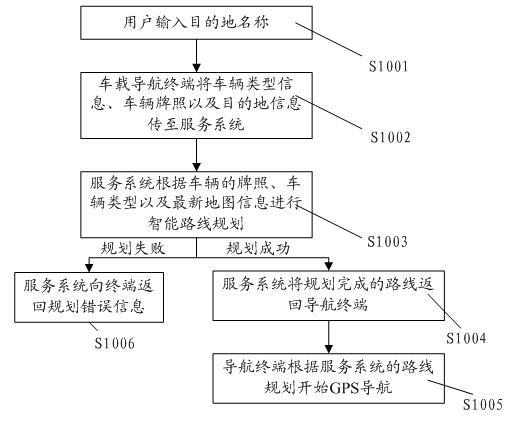
[0023] Such as figure 1 As shown, in S1001, after the vehicle navigation terminal is started, the user opens the destination interface and inputs the name of the desired destination.

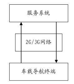
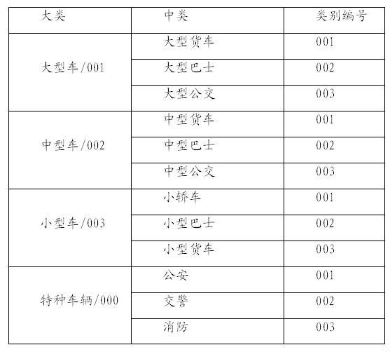
[0024] After confirmation, S1002, the navigation terminal will automatically transmit the type information of the vehicle, such as trucks, cars, etc., the license plate of the vehicle, and the destination information of the user to the service system through the wireless network. The type information is transmitted in the form of encoding, and the encoding rules are as follows: image 3 As shown, the large truck is...


PUM


Abstract

The invention relates to a navigation path planning method which is characterized by comprising the following steps of: acquiring the class of the current vehicle by a system; acquiring the running path suitable for the vehicle by the system; and planning the running path of the vehicle according to the acquired path by the system. After the scheme of the invention is adopted, a navigation terminal comprises a vehicle class setting module, and a service system is adopted to carry out intelligent identification on the class of the vehicle, and reasonable navigation paths for different classes of vehicles can be planned out at different periods under different traffic limit policies to avoid the problem of penalty on the vehicle, caused by incorrect navigation path, and meanwhile, the working pressure of a traffic management department is also reduced. The invention is suitable for adopting a global position system (GPS) or a Big Dipper satellite navigation system or a GLONASS or GALILEO positioner.

Description

technical field [0001] The invention relates to a navigation route planning method, system and terminal. Background technique [0002] The global satellite positioning system uses the satellite network located more than 20,000 kilometers above the earth to continuously transmit positioning signals to the earth, and the navigation terminal equipment can determine its own position and navigate through these positioning signals. [0003] Along with the raising of people's living standard, on-board navigation equipment is installed on more and more cars. However, the speed of urban construction makes it impossible for many roads to drive in both directions, or there are different restrictions on different vehicles. On some roads, small cars can drive, but large cars cannot drive. This situation sometimes leads to the route planned by the navigation terminal. It does not meet the restriction requirements of the traffic management department, which may cause the vehicle to be det...

Claims


Application Information

Patent Timeline
IPC IPC(8): G01C21/34G01C21/36
Inventor 何毅华
Owner TECHTOTOP MICROELECTRONICS
Why Eureka
Try Eureka