Pseudo-three-dimensional wireless sensor network routing method based on geographical position

A wireless sensor, geographic location technology, used in wireless sensor networks, communication fields

Inactive Publication Date: 2011-11-09
UNIV OF ELECTRONICS SCI & TECH OF CHINA
View PDF2 Cites 20 Cited by
  • Summary
  • Abstract
  • Description
  • Claims
  • Application Information

AI Technical Summary

Problems solved by technology

The above analysis shows that although figure 1 The Euclidean distance from node C to the destination node is the shortest, but

Method used


Image

  • Pseudo-three-dimensional wireless sensor network routing method based on geographical position
  • Pseudo-three-dimensional wireless sensor network routing method based on geographical position
  • Pseudo-three-dimensional wireless sensor network routing method based on geographical position

Examples


Embodiment Construction

[0027] The present invention will be further described below in conjunction with the accompanying drawings and specific embodiments.

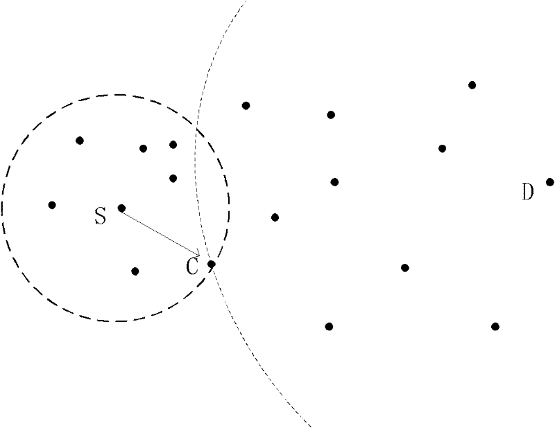
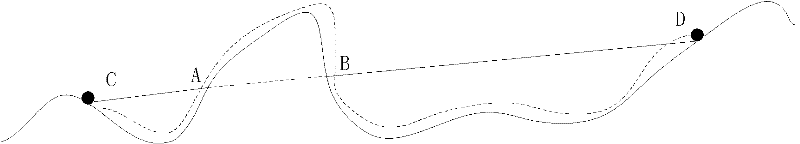
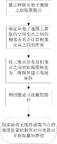
[0028] The pseudo three-dimensional wireless sensor network routing method based on geographic location of the present invention selects some discrete points on the surface of the electronic map by means of spatial point selection, and these discrete points can reflect the surface fluctuation trend of the electronic map as a whole. By calculating the Euclidean distance between adjacent discrete points and mapping them to the projected points on the two-dimensional plane through the adjacent relationship, and using the shortest path calculation method in graph theory (such as the Dijkstra algorithm), a certain point on the surface of the electronic map can be calculated. The shortest path between the projection point of one discrete point and the projection point of another discrete point. Because this path is generated from the projection point...


PUM


Abstract

The invention provides a pseudo-three-dimensional wireless sensor network routing method based on a geographical position. The method comprises the following specific steps of: (1) establishing grids and obtaining discrete points from an electronic map; (2) determining the neighboring relation between space intersection points obtained from the electronic map, and calculating the distance between adjacent intersection points; (3) converting a distance map between three-dimensional point distribution and adjacent points into a two-dimensional map, and establishing an adjacency matrix; (4) searching the shortest path by using the graph theory; and (5) mapping the geographical position of the actual wireless sensor node to the corresponding discrete point to obtain the shortest path. The invention has the advantage of comprehensively utilizing the gridded electronic map and the Dijkstra shortest path algorithm to accurately calculate the optimal route between the transmitting node and the destination node on undulating terrain for the first time.

Description

technical field [0001] The invention belongs to the field of communication technology, in particular to the field of wireless sensor network technology. Background technique [0002] With the rapid development of sensor technology, embedded computing technology, and low-power wireless communication technology, miniature wireless sensors with sensing, wireless communication, and information processing capabilities have begun to appear. Hundreds of cheap, low-power sensors are organized into Wireless Sensor Network (WSN) can cooperatively monitor and sense a variety of environmental information such as sound, light, and electricity within its network coverage area, and transmit it to a remote base station for processing. These sensors have dual functions, both as a data collector and as a data forwarder, and after the base station collects the data, it performs certain processing and then sends it to remote users through a wired or wireless network. The wireless sensor network...

Claims


Application Information

Patent Timeline
IPC IPC(8): H04W40/20H04W84/18
Inventor 于富财韩阳龙黄浩军胡光岷
Owner UNIV OF ELECTRONICS SCI & TECH OF CHINA
Why Eureka
Try Eureka