A method and system for judging spatial relationship based on rasterized gis

A technology of spatial relationship and grid, applied in the field of GIS, can solve the problems of complexity, low efficiency and large amount of calculation.

Inactive Publication Date: 2011-12-07
INST OF COMPUTING TECH CHINESE ACAD OF SCI
View PDF1 Cites 23 Cited by
  • Summary
  • Abstract
  • Description
  • Claims
  • Application Information

AI Technical Summary

Problems solved by technology

Especially in the case where line segments intersect at endpoints and line segments overlap, how to distinguish the exit point and entry point of the intersection point is very complicated and the efficiency is reduced
The line segment intersection algorithm used in this kind of practice generally adopts the plane scanning algorithm. The advantage is that the result is more accurate. The disadvantage is that due to frequent operations such as coordinate sorting and angle calculation, the amount of calculation is large.

Method used


Image

  • A method and system for judging spatial relationship based on rasterized gis
  • A method and system for judging spatial relationship based on rasterized gis
  • A method and system for judging spatial relationship based on rasterized gis

Examples


Embodiment Construction

[0142] The specific implementation manner of the present invention is given below, and the present invention is further described in detail in conjunction with the accompanying drawings.

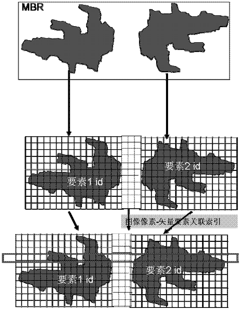
[0143] Step 100, input the graphics represented by the geometry expressed in the vector mode, and cover the graphics by the grid unit, the grid unit takes the element ID that covers the graphics as the element index, and the grid unit uses the coordinate value Position index, block the graphics forming the index, and each grid unit has information about the actual occupied area of ​​the graphics covered by it in the grid unit;

[0144] The core idea is: the Bresenham line generation algorithm with subpixel accuracy is used. The Bresenham line generation algorithm is a method for generating lines based on an error discriminant. The difference from the traditional Bresenham algorithm is that the process of using error judgment to select pixels is based on sub-pixels. One pixel is divided into ...


PUM


Abstract

The invention relates to a method and system for judging spatial relationship based on gridded GIS. Step 1, input the graphics represented by the geometry represented by the vector mode, cover the graphics by the grid unit, the grid unit takes the element ID that covers the graphics as the element index, and the grid unit takes the coordinate value Position index, which divides the geometric expression forming the index into blocks, and each grid unit has the information of the actual occupied area of ​​the graphics covered by it in the grid unit; step 2, two compressed grid units In the covered graphics, the grid units with the same coordinates correspond to each other, and the information of the actual occupied area of ​​the corresponding two grid units is compared, and the two grid units covered by the grid unit are obtained in a vector form. The result of judging the GIS spatial relationship expressed by the represented geometry.

Description

technical field [0001] The present invention relates to the field of GIS (Geographical Information System, geographic information system), in particular to a method for judging a GIS spatial relationship and a system thereof. Background technique [0002] Geographical information refers to information directly or indirectly related to the spatial position on the earth, and is often called spatial information. It is estimated that more than 80% of the data have spatial attributes, and the relationship between these spatial data has become an important part of the information system relationship, and its application is very extensive. [0003] Generally speaking, Geographical Information System (GIS for short) can be defined as a computer system for collecting, storing, relating, processing, retrieving, analyzing and expressing geospatial data. technology. [0004] With the development of GIS itself and the informatization of economy and society, GIS has begun to integrate i...

Claims


Application Information

Patent Timeline
Patent Type & Authority Applications(China)
IPC IPC(8): G06F17/30
Inventor 程振林董慧赵艳伟方金云
Owner INST OF COMPUTING TECH CHINESE ACAD OF SCI
Why Eureka
Try Eureka