Spatial information functional plug-in workflow construction method

A workflow and functional component technology, applied in special data processing applications, instruments, electrical digital data processing, etc., can solve problems such as the inability to realize visual GIS functional modeling and the inability to support functional components.

Active Publication Date: 2012-01-11
武汉中地数码科技有限公司 +1
View PDF3 Cites 15 Cited by
  • Summary
  • Abstract
  • Description
  • Claims
  • Application Information

AI Technical Summary

Problems solved by technology

[0003] Many applications in GIS technology can be decomposed into functional processes for continuous execution, but the process control method and interpretation operation mode of the original office automation-oriented workflow management system cannot support the functional components in the GIS function library, and thus cannot realize visualization GIS Functional Modeling

Method used


Image

  • Spatial information functional plug-in workflow construction method
  • Spatial information functional plug-in workflow construction method
  • Spatial information functional plug-in workflow construction method

Examples


Embodiment Construction

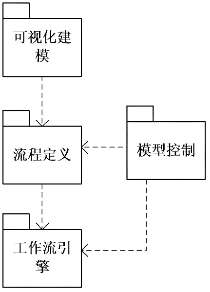
[0021] Such as figure 1 As shown, the design description of the four modules of the present invention and the description of the relationship between related modules. The four modules include workflow visualization modeling tool, workflow definition module, workflow model control module, and workflow engine module.

[0022] The description of the functional modules is shown in the figure below:

[0023]

[0024]

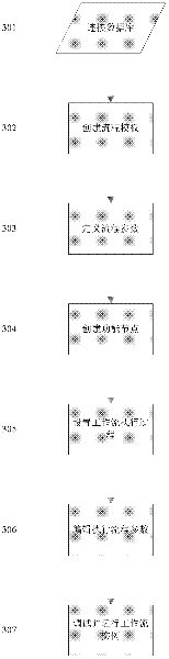
[0025] The specific implementation of the method for building the workflow of the spatial information function plug-in of the present invention will be further described below in conjunction with the accompanying drawings. Such as figure 2 Shown:

[0026] 1. Connect to the database and set the data source;

[0027] Set the data source, connect to the database, and create a workflow database to store workflow-related data.

[0028] 2. Create a process template and set process parameter information;

[0029] Create a process template, add process parameter...


PUM


Abstract

The invention relates to a geography information system (GIS) technology, in particular to a spatial information functional plug-in workflow construction method which comprises the steps that: Step (1) a database is connected and a data source is set; Step (2) a process template is created, process parameter information is added according to the factors of a process realization function, and the parameter information which is filled in is written into a workflow database table; Step (3) process parameters are defined for transmitting in and out parameters required by all functional nodes in a process; Step (4) a GIS workflow functional node is created, and the properties of the functional node are edited; Step (5) workflow starting and ending logic, activity execution logic and process control logic are defined; Step (6) the process parameters are edited and executed; and Step (7) the embodiment of workflow is debugged and operated according to workflow engine algorithm based on an activity state promoting model. The spatial information functional plug-in workflow construction method can support functional components in a GIS function library, so as to provide support for realizing visualized GIS functional modeling.

Description

technical field [0001] The present invention relates to workflow technology, and in particular to geographic information system technology (Geography Information System GIS), it is a kind of spatial information function plug-in workflow construction method. Background technique [0002] Workflow technology refers to a business process that is fully or partially supported or automatically processed by a computer. It was originally used for document management and office automation. With the continuous development of software platform technology, workflow technology has also continuously expanded its application fields. [0003] Many applications in GIS technology can be decomposed into functional processes for continuous execution, but the process control method and interpretation operation mode of the original office automation-oriented workflow management system cannot support the functional components in the GIS function library, and thus cannot realize visualization GIS ...

Claims


Application Information

Patent Timeline
Patent Type & Authority Applications(China)
IPC IPC(8): G06F9/44G06F17/30
Inventor 吴信才徐世武张发勇吴亮万波万林罗显刚杨乃许凯丁开华吴边
Owner 武汉中地数码科技有限公司
Why Eureka
Try Eureka