Dynamic lever arm compensating method of position and posture measuring system (POS) for aerial remote sensing

A technology of aerial remote sensing and measurement system, applied in the field of aerial remote sensing, can solve the problems such as the difficulty of accurate compensation of the POS lever arm, and achieve the effect of improving precision and high precision

Inactive Publication Date: 2012-03-28
BEIHANG UNIV
View PDF4 Cites 28 Cited by
  • Summary
  • Abstract
  • Description
  • Claims
  • Application Information

AI Technical Summary

Problems solved by technology

This method aims at the real-time change of the lever arm between the IMU measurement center and the GPS antenna phase center caused by the frame rotation of the three-axis inertial stabilized platform, and calculates the dynamic lever arm between the center of the three-axis inertial stabilized platform and the IMU measurement center in real time , get the actual lever arm between the IMU measurement center and the GPS antenna phase center, and calculate the angular velocity of the initial coordinate system of the three-axis inertial

Method used


Image

  • Dynamic lever arm compensating method of position and posture measuring system (POS) for aerial remote sensing
  • Dynamic lever arm compensating method of position and posture measuring system (POS) for aerial remote sensing
  • Dynamic lever arm compensating method of position and posture measuring system (POS) for aerial remote sensing

Examples


Embodiment Construction

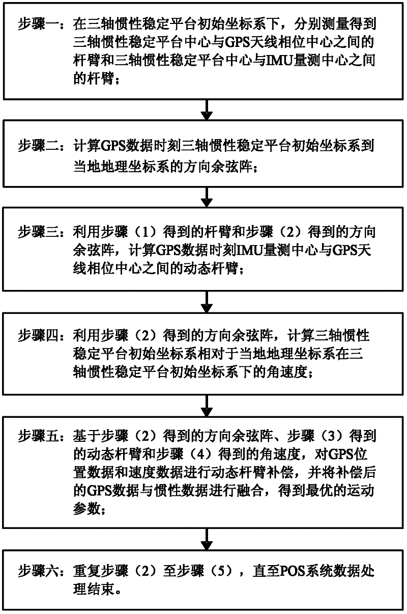
[0017] As attached to the manual figure 1 Shown, concrete implementation of the present invention comprises the following steps:

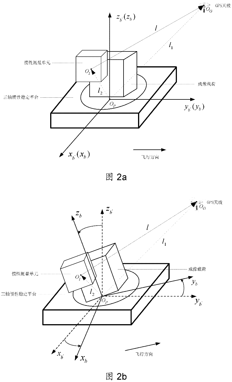
[0018] 1. Set the three-axis inertial stabilized platform to the leveling mode, the three-axis inertial stabilized platform controls the three-axis frame, so that the output of the three-axis electric encoder of the inertial stabilized platform is zero, and set the internal frame coordinate system of the three-axis inertial stabilized platform at this time is the initial coordinate system ox of the three-axis inertial stabilized platform b′ the y b′ z b′ , denoted by b′; let the real-time inner frame coordinate system ox of the three-axis inertial stabilized platform b the y b z b Denoted by b; let the local geographic coordinate system ox n the y n z n Expressed in n. In the initial coordinate system ox of the three-axis inertial stabilized platform b′ the y b′ z b′ Next, use the theodolite to measure the center O of the three-axis in...


PUM


Abstract

The invention provides a dynamic lever arm compensating method of a position and posture measuring system (POS) for aerial remote sensing. The method comprises the following steps of: to solve the problem of real-time variation of the lever arm between a measuring center of an inertia measuring unit (IMU) and phase center of a GPS (Global Positioning System) antenna due to rotation of a three-axis inertia stabilizing platform frame, obtaining an actual lever arm between the IMU measuring center and the phase center of the GPS antenna through calculating a dynamic lever arm between the center of the three-axis inertia stabilizing platform and the IMU measuring center in real time; and figuring out angular velocity of an initial coordinate system of the three-axis inertia stabilizing platform under the initial coordinate system of the three-axis inertia stabilizing platform relative to a local geographic coordinate system so as to compensate the dynamic lever arm. The dynamic lever arm compensating method provided by the invention has the characteristics of high accuracy, simplicity in operation and easiness for realization; the problem that the POS lever arm is hard to be accurately compensated while the three-axis inertia stabilizing platform is adopted for aerial remote sensing is solved; and the accuracies of POS and aerial remote sensing imaging load are improved.

Description

technical field [0001] The invention relates to a position and attitude measurement system (POS) dynamic lever arm compensation method for aerial remote sensing, belongs to the field of aerial remote sensing, is applied to aerial remote sensing using a three-axis inertial stable platform, and improves the accuracy of POS and aerial remote sensing imaging loads. Background technique [0002] Aerial remote sensing is a high technology that uses aircraft as a carrier to obtain various spatial and geographical information on the earth's surface by using remote sensing payloads. When the aerial remote sensing system performs high-resolution imaging, the payload is required to move in a straight line at a constant speed in space. However, the aircraft will inevitably be affected by external disturbances such as gusts and turbulence, which will cause the payload to deviate from the ideal trajectory, resulting in a decline in the imaging quality of the payload. Therefore, to achieve...

Claims


Application Information

Patent Timeline
IPC IPC(8): G01C21/24G01S19/49G01S19/52
Inventor 钟麦英曹全房建成宫晓琳
Owner BEIHANG UNIV
Why Eureka
Try Eureka