Method for generating variable resolution digital elevation model

A digital elevation model and resolution technology, applied in height/level measurement, measurement devices, instruments, etc., can solve the problems of invariability, irregular resolution, and low measurement accuracy of terrain.

Inactive Publication Date: 2012-04-25
REMOTE SENSING APPLIED INST CHINESE ACAD OF SCI
View PDF4 Cites 6 Cited by
  • Summary
  • Abstract
  • Description
  • Claims
  • Application Information

AI Technical Summary

Problems solved by technology

[0003] When using close-range photogrammetry or terrestrial laser scanning to measure terrain, the accuracy of terrain measurement varies with distance in a certain way. The farther away from the measurement point, the lower the accuracy of terrain measurement. The terrain accuracy can be expressed as an accuracy standard, which c...

Method used


Image

  • Method for generating variable resolution digital elevation model
  • Method for generating variable resolution digital elevation model
  • Method for generating variable resolution digital elevation model

Examples


Embodiment Construction

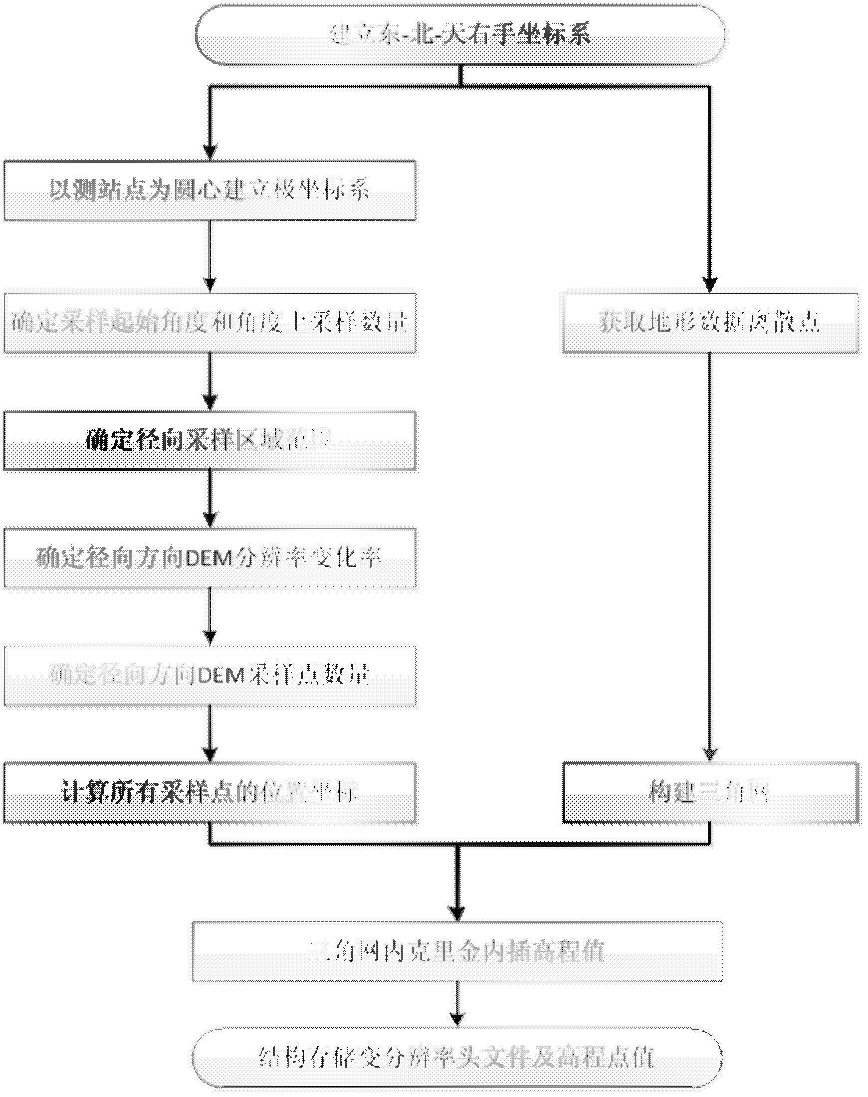
[0012] The present invention will be described in detail below in conjunction with the accompanying drawings and embodiments.

[0013] The present invention obtains the generation method of variable resolution digital elevation model by close-range photogrammetry or ground laser scanning, comprises the following steps (such as figure 1 shown):

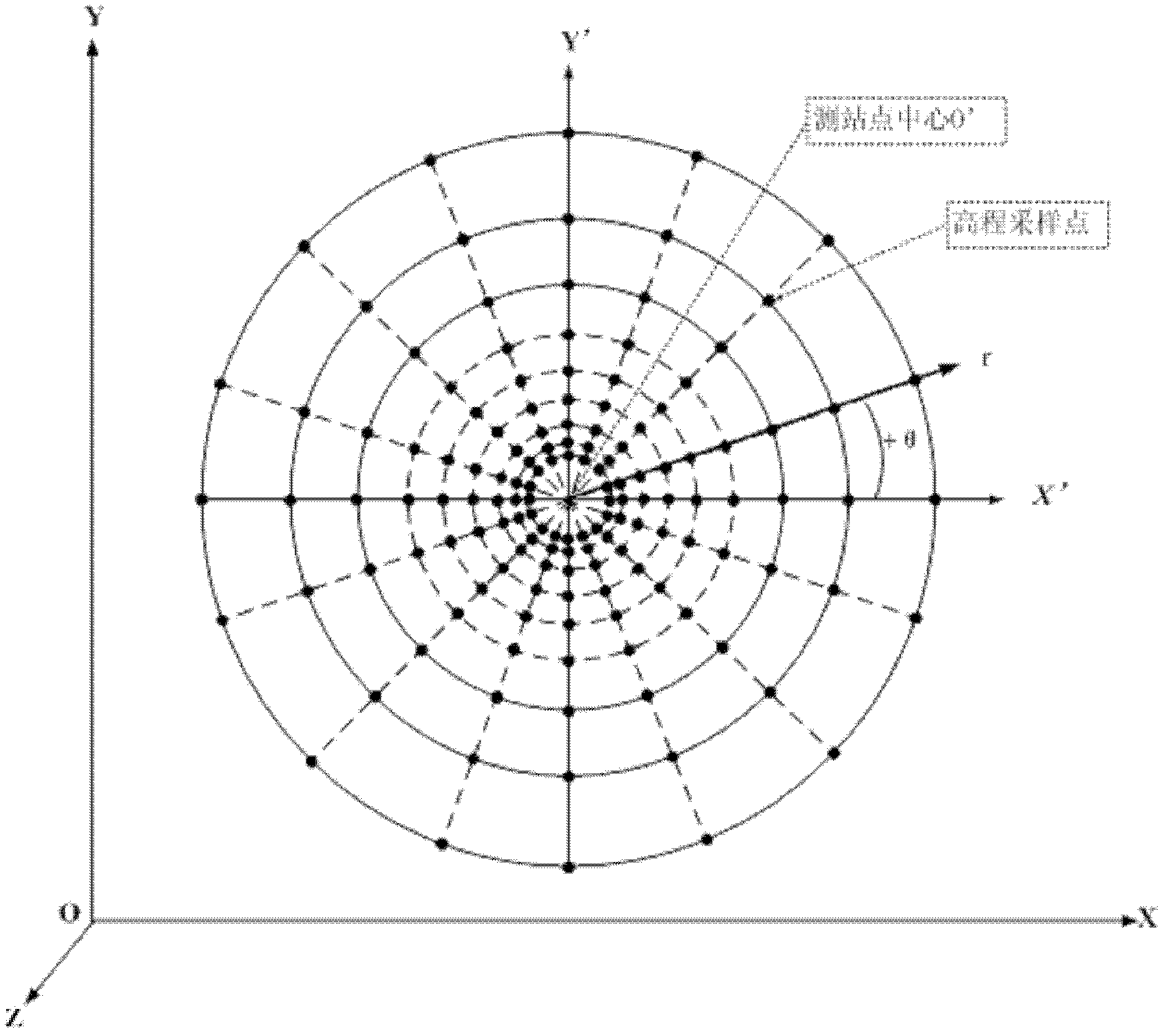
[0014] 1. Establish the east-north-sky right-hand coordinate system according to the measured terrain area, and establish a new plane coordinate system X'O'Y' in the XOY plane of the east-north-sky right-hand coordinate system, and use the new plane The origin of the coordinate system is the pole to establish a polar coordinate system (such as figure 2 shown).

[0015] Taking the east direction of the measured topographic area as the X axis, the north direction as the Y axis, and the direction perpendicular to the XOY plane pointing to the sky as the Z axis, establish the east-north-sky right-handed coordinate system (that is, the O...


PUM


Abstract

The invention relates to a method for generating a variable resolution digital elevation model. The method comprises the following steps of: establishing an east-north-sky right-handed coordinate system according to a measured topographic region, establishing a new plane coordinate system X'O'Y' in an XOY plane by using a measurement station point as a center, and establishing a polar coordinate system by using the original point of the new plane coordinate system as a pole and the direction far away from the center of the measurement station point as a polar axis; acquiring a three-dimensional data discrete point of the measured topographic region under the east-north-sky right-handed coordinate system; determining an angle sampling range in the polar coordinate system according to the measured topographic region, setting angle sampling intervals, and calculating the quantity of elevation sampling points required in the angle range; determining a radial sampling range along each angle direction, determining radial sampling change rates and sampling intervals, and calculating the quantity of the elevation sampling points required in the radial direction; and acquiring polar coordinates of all the elevation sampling points within the angle sampling range and the radial sampling range, constructing an irregular triangulation network according to the data discrete point, and calculating through interpolation to obtain elevation values of all the elevation sampling points. The method can be widely applied to data storage and expression during topographic and geomorphic measurement.

Description

technical field [0001] The present invention relates to a method for generating a digital elevation model, in particular to a variable-resolution digital elevation model that is suitable for expressing a digital elevation model obtained by close-range photogrammetry or ground laser scanning and that can maintain the different elevation accuracy of the original terrain generate method. Background technique [0002] A digital elevation model (DEM) is a digital representation of a terrain surface using a set of ordered terrain sampling points. Digital elevation models commonly used in the prior art include regular grid (Grid) and irregular triangular network (TIN). The regular grid is to divide the coverage area of ​​the digital elevation model into regularly arranged square grids, store the elevation value at the center point of each grid, and record the position of the starting point and the grid spacing, then the plane position of any grid point It can be obtained by calcu...

Claims


Application Information

Patent Timeline
IPC IPC(8): G01C5/00G01C11/00
Inventor 刘召芹彭嫚邸凯昌吴凯万文辉
Owner REMOTE SENSING APPLIED INST CHINESE ACAD OF SCI
Why Eureka
Try Eureka