Navigation information zero tight combination method based on WSN (Wireless Sensors Network)/MINS (Micro Inertial Navigation System)

A technology of navigation information and integrated navigation, which is applied in navigation computing tools and other directions, and can solve problems such as the influence of filtering accuracy

Active Publication Date: 2012-06-13
SOUTHEAST UNIV
View PDF4 Cites 25 Cited by
  • Summary
  • Abstract
  • Description
  • Claims
  • Application Information

AI Technical Summary

Problems solved by technology

Although this method fuses the original data, the filtering accuracy is greatly affected

Method used


Image

  • Navigation information zero tight combination method based on WSN (Wireless Sensors Network)/MINS (Micro Inertial Navigation System)
  • Navigation information zero tight combination method based on WSN (Wireless Sensors Network)/MINS (Micro Inertial Navigation System)
  • Navigation information zero tight combination method based on WSN (Wireless Sensors Network)/MINS (Micro Inertial Navigation System)

Examples


Embodiment Construction

[0021] The invention will be further described in detail below in conjunction with the drawings

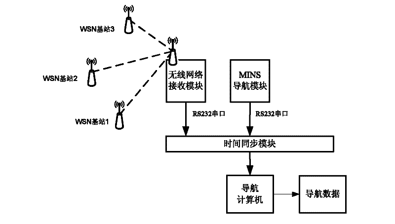
[0022] Such as figure 1 Shown is the WSN / MINS high-precision real-time integrated navigation system.

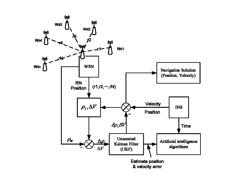
[0023] The present invention is a method for unbiased tight combination of navigation information based on WSN / MINS integrated navigation, including the following steps: pass UKF in the training phase with WSN signals, and use the position and speed information measured by MINS at each moment and the WSN measurement The distance information between the unknown node and the known node at each time is fused to obtain the MINS optimal error estimate in the relative local relative coordinate system at each time. There is no need to obtain relevant navigation information such as the position and speed of the unknown node at each moment measured by the WSN.

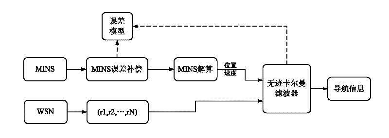
[0024] Such as figure 2 As shown, the system equation of the unscented Kalman filter takes the position error of the two directions ...


PUM


Abstract

The invention discloses a navigation information zero tight combination method based on WSN (Wireless Sensors Network)/MINS (Micro Inertial Navigation System), and belongs to the technical field of combination and positioning in the complicated environment. The MINS (Micro Inertial Navigation System) and the WSN (Wireless Sensors Network) are integrated in a local relative coordinate system, the obtained synchronous navigation data is fused in a navigation computer through the UKF (Unscented Kalman Filter), so as to acquire the novel combination navigation method which is higher in precision, wider in navigation coverage and more stable than any other single navigation method.

Description

Technical field [0001] An unbiased tight combination method of navigation information based on WSN / MINS integrated navigation belongs to the technical field of combined positioning in a complex environment. Background technique [0002] The demand for precise location information of unknown nodes has promoted the development of precise positioning technology, and this trend will remain unchanged for a long time to come. In recent years, the wireless sensor network (Wireless Sensors Network, WSN) has shown great potential in the field of short-distance positioning due to its low cost, low power consumption and low system complexity. WSN makes it possible to locate unknown nodes in areas without GPS signals, the so-called "blind areas", such as indoor, high-rise building dense urban areas, mines, tunnels, etc., but the communication technology used by WSN is usually short distance Wireless communication technology (such as ZigBee, WIFI, etc.), so if you want to complete long-dista...

Claims


Application Information

Patent Timeline
IPC IPC(8): G01C21/20
Inventor 陈熙源徐元李庆华
Owner SOUTHEAST UNIV
Why Eureka
Try Eureka