Vehicle-mounted mobile mapping device

A mapping device, vehicle-mounted mobile technology, applied in the direction of measurement device, radio wave measurement system, electromagnetic wave re-radiation, etc., can solve the problems of GNSS lock loss, sensor data time and space asynchrony, etc.

Inactive Publication Date: 2012-06-20
BEIHANG UNIV
View PDF4 Cites 18 Cited by
  • Summary
  • Abstract
  • Description
  • Claims
  • Application Information

AI Technical Summary

Problems solved by technology

[0003] The technical problem to be solved by the present invention is to solve the problem of GNSS loss of lock caused by other surveying and mapping systems due to tunnels, bridges, urban canyons, trees, etc. The time and space asynchronous problem of each sensor data when using multi-...

Method used


Image

  • Vehicle-mounted mobile mapping device
  • Vehicle-mounted mobile mapping device
  • Vehicle-mounted mobile mapping device

Examples


Embodiment Construction

[0042] The present invention will be described in further detail below in conjunction with the accompanying drawings and specific embodiments.

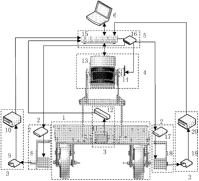
[0043] Such as figure 1 A vehicle-mounted mobile mapping device is shown, which includes: a carrier platform system 1 , a drive system 2 , an inertial navigation system 3 , a three-dimensional data acquisition system 4 , a communication system 5 and a host computer 6 . in:

[0044] The carrying platform system 1 carries the entire device to move in the scene space; the carrying platform system 1 includes a carrying platform, left front wheel, right front wheel, left rear wheel and right rear wheel; the carrying platform system 1 drives the left front wheel in the system 2 The drive motor 8 drives the left front wheel, and the right front wheel drive motor 18 in the drive system 2 drives the right front wheel to realize platform motion; the left encoder 9 in the inertial navigation system 3 is connected with the left front wheel to re...


PUM


Abstract

The invention discloses a vehicle-mounted mobile mapping device which comprises a transport platform system, a driving system, an inertial navigation system, a three-dimensional data acquisition system, a communication system and an upper computer, wherein the three-dimensional data acquisition system is utilized for acquiring polar radius information of the surface of a scene, and the transport platform system is applied to carrying the whole device; the device is controlled by the driving system to move in the scene; the inertial navigation system is used for getting spatial six-degree-of-freedom position and attitude parameters of the device; the communication system is applied to transmit the position and attitude parameters of the device, which are obtained by the inertial navigationsystem and the polar radius information of the scene, which is acquired by the three-dimensional data acquisition system to the upper computer in a real-time manner; and a three-dimensional point cloud image of the scene is reconstructed by processing polar radius of the scene and the information of the spatial six-degree-of-freedom position and attitude parameters of the device through software of the upper computer. The vehicle-mounted mobile mapping device disclosed by the invention can overcome the shortcomings of long production cycle of data, high production cost of the data, great difficulty in getting the effective data in places which can not be reached by staff and the like of a traditional measurement method and realize indoor and outdoor fast and accurate mapping, and further has broad application prospects in the fields of urban planning, reconstruction of accident scenes, archeology and the like.

Description

technical field [0001] The invention relates to a non-contact measurement technology, in particular to a vehicle-mounted mobile mapping device, which has broad application prospects in the fields of urban planning, accident scene reconstruction, archaeology and the like. Background technique [0002] At present, the existing vehicle-mounted mobile mapping systems are all built with advanced sensors such as GPS, CCD, INS, laser or dead reckoning systems. Through the high-speed travel of the carrier, the spatial data and attribute data of ground objects can be quickly collected. Because the system uses GPS positioning technology, the system is only suitable for mapping in open environments, not indoors, tunnels, cities and other environments. Therefore, there is an urgent need for a vehicle-mounted mobile mapping device to meet the mapping work in scenarios where GPS signals cannot be accepted. Contents of the invention [0003] The technical problem to be solved by the pre...

Claims


Application Information

Patent Timeline
IPC IPC(8): G01S17/89
Inventor 胡少兴朱林林张爱武陈春鹏
Owner BEIHANG UNIV
Why Eureka
Try Eureka