Method for automatically and accurately identifying sea ice edge

A recognition method and outer edge technology, applied in character and pattern recognition, instruments, computer components, etc., can solve problems such as roughness, rough sea ice outer edge line, and inaccurateness, so as to improve efficiency and sea ice edge line Accurate, avoid subjectivity effects

Inactive Publication Date: 2012-07-11
OCEAN UNIV OF CHINA
View PDF4 Cites 6 Cited by
  • Summary
  • Abstract
  • Description
  • Claims
  • Application Information

AI Technical Summary

Problems solved by technology

These two methods are relatively rough, and because there are a lot of trivial ice floes in the outer edge of sea ice, the outer edge of sea ice is not smooth and accurate, especially for high-resolution remote sensing data.

Method used


Image

  • Method for automatically and accurately identifying sea ice edge
  • Method for automatically and accurately identifying sea ice edge
  • Method for automatically and accurately identifying sea ice edge

Examples


Embodiment Construction

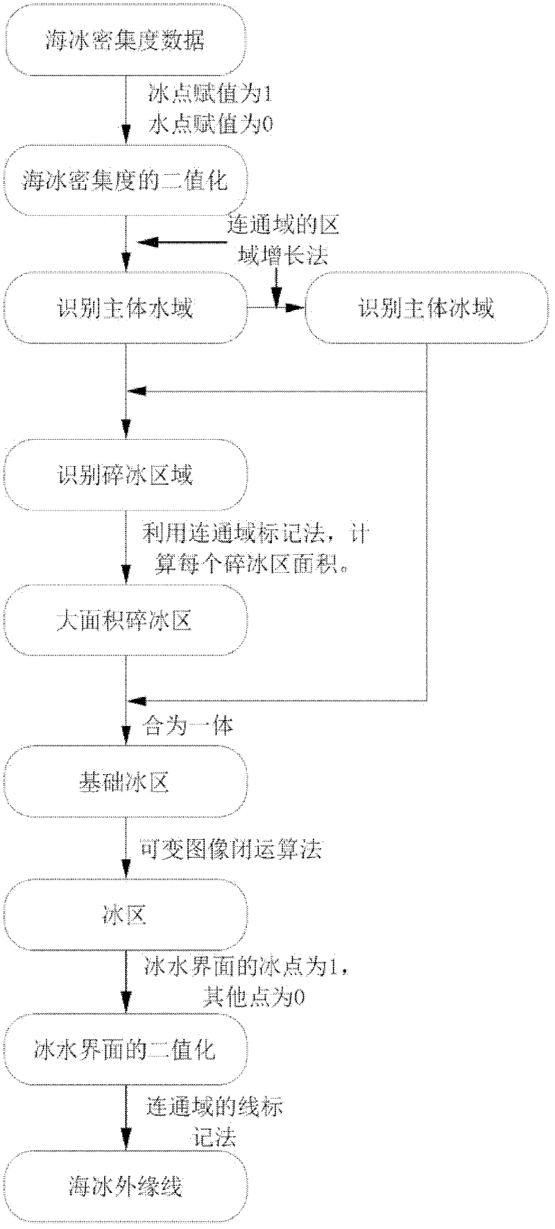
[0034] Such as figure 1 Shown, the automatic and accurate identification method of sea ice outer edge line of the present invention, this method comprises:

[0035] 1) Obtain sea ice density data; the sea ice density data can be obtained through satellite inversion, sea ice aerial photography data, etc.;

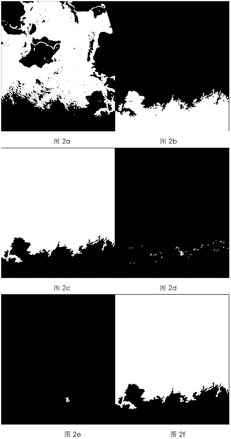
[0036] 2) Binarize the sea ice density data: identify the points with sea ice density equal to 0 as water areas, and identify the points with sea ice density greater than 0 as ice areas, land or clouds as 1;

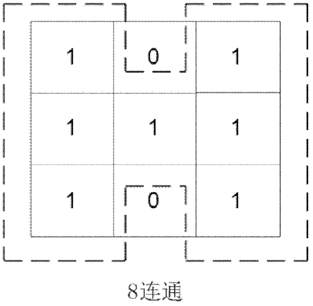
[0037] 3) Identify the main water area: specifically, for the binary data obtained in step 2), given the coordinates (wlat, wlon) of any point in the permanent waters, the connected domain processing is performed on the coordinate points (wlat, wlon), and the coordinate point Connected points are assigned a value of 1, and disconnected points are assigned a value of 0, and the main water area composed of points assigned a value of 1 is obtained;

[0038] 4) Identify ...


PUM


Abstract

The invention relates to a method for automatically and accurately identifying a sea ice edge, which comprises the following steps of: carrying out binarization processing on sea ice concentration data; identifying a main body water area and a main body ice area by utilizing the binarization data; judging data points with the equal value in the main body water area and the main body ice area intobroken ice areas; using the broken ice areas with large areas and the main body ice area as basic ice areas; carrying out variable closing operation processing on basic ice area data until all communication areas are combined into one communication area; carrying out binarization processing on the obtained communication area to determine the positon of the sea ice edge; and finally, outputting data of the position of the sea ice edge. The method disclosed by the invention is simple, is accurate to identify, has the advantage of automation and is suitable for theoretical research and practicalapplication; and the objectivity of manual interference is avoided, various data fields can be adopted, the sea ice edge can be provided in real time according to remote sensing inversion data, and the method has very important practical value for safety construction of monitoring of sea ice disasters, marine safety constructing and a marine oil platform.

Description

technical field [0001] The invention relates to an automatic and accurate identification method for the outer edge of sea ice, which belongs to the fields of marine science and marine remote sensing. Background technique [0002] At present, the inversion technology of sea ice density is relatively mature, mainly including the inversion technology based on microwave data and the inversion technology based on visible light and infrared light. Microwave data is less affected by clouds and fog, but the resolution is low. The AMSR-E product with the highest rate is only 6.25km. Visible light and infrared light have high resolution, such as AVHRR data is 1.1km, MODIS data has a maximum resolution of 250m, and LandSat data has a resolution of 30m, but these data are affected by polar night and clouds. The two kinds of data complement each other and can provide the ability to monitor sea ice density in frozen sea areas. But no matter what kind of data is used, the outer edge of s...

Claims


Application Information

Patent Timeline
Patent Type & Authority Applications(China)
IPC IPC(8): G06K9/46
Inventor 苏洁王维波于飞付红丽
Owner OCEAN UNIV OF CHINA
Why Eureka
Try Eureka