Quick low-level image matching method by utilizing flight control data

A technology of flight control data and matching method, which is applied to the interpretation of photos and other directions, can solve the problems of fast matching of images without flight control data, and achieve the effect of avoiding repeated calculation and reducing complexity.

Active Publication Date: 2012-07-25
江苏星月测绘科技股份有限公司
View PDF6 Cites 14 Cited by
  • Summary
  • Abstract
  • Description
  • Claims
  • Application Information

AI Technical Summary

Problems solved by technology

However, in the current research and application of image matching, there is no case of using flight control data to achieve rapid image matching

Method used


Image

  • Quick low-level image matching method by utilizing flight control data
  • Quick low-level image matching method by utilizing flight control data
  • Quick low-level image matching method by utilizing flight control data

Examples


Embodiment Construction

[0028] The following examples are used to illustrate the present invention, but are not intended to limit the scope of the present invention.

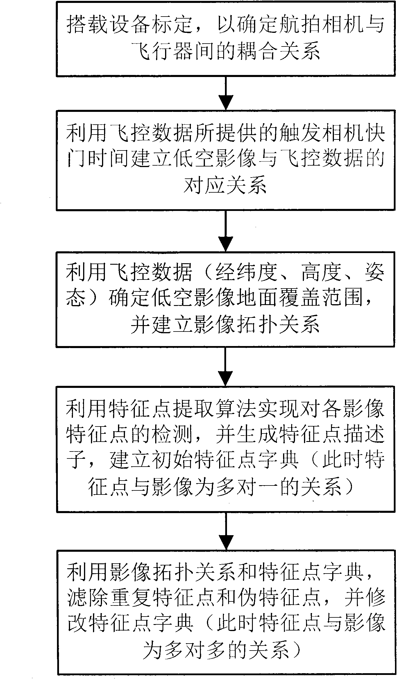
[0029] figure 1 Shown is a flow chart of a method for quickly matching low-altitude images using flight control data according to the present invention. The method specifically includes the following steps: carrying equipment calibration to determine the coupling relationship between the aerial camera and the aircraft (rotation matrix and translation matrix) ; Use the trigger camera shutter time provided by the flight control data to establish the corresponding relationship between the low-altitude image and the flight control data; use the UAV flight control data (including: trigger camera shutter time, aircraft geographic coordinates, altitude and flight attitude) to determine The ground coverage of low-altitude images, and establish the topological relationship between images; use the feature point extraction algorithm (such as SURF...


PUM


Abstract

The invention relates to a quick low-level image matching method by utilizing flight control data, comprising the steps of: marking loading equipment to determine a coupling relation of an aerial photography camera and an aircraft; building a corresponding relation of low-level images and flight control data through the camera shutter triggering time provided by the flight control data; determining a ground coverage range of the low-level images through the flight control data (longitude and latitude, height and postures), and building an image topological relation; detecting image characteristic points through a characteristic point extraction algorithm, generating a characteristic point descriptor and building an initial characteristic point dictionary; and filtering repeated characteristic points or pseudo characteristic points through the image topological relation and the characteristic point dictionary, and amending the characteristic point dictionary to generate a final image matching relation. The matching method disclosed by the invention improves image matching efficiency and reliability and provides support for the conventional reconstruction of large-scene quick images.

Description

technical field [0001] The invention relates to the technical field of geospatial information acquisition and reconstruction, in particular to a large-scene low-altitude image matching method. Background technique [0002] Fast and reliable 3D reconstruction of large scenes can provide decision support for urbanization management, cultural relics protection, disaster reduction and emergency response, etc. The 3D model acquisition methods of real objects are mainly divided into active methods and passive methods. Among them, the active method is represented by the method using LiDAR (Light Detection And Ranging, laser detection and ranging) technology; the passive method refers to the three-dimensional reconstruction method based on two-dimensional images. Usually, image-based 3D reconstruction methods have the characteristics of low cost, flexibility, and the ability to directly obtain color textures, and are widely used in 3D reconstruction of large scenes. At present, gr...

Claims


Application Information

Patent Timeline
Patent Type & Authority Applications(China)
IPC IPC(8): G01C11/04
Inventor 吴立新沈永林
Owner 江苏星月测绘科技股份有限公司
Why Eureka
Try Eureka