Remote sensing calibration comprehensive method and calibration equipment vehicle

A comprehensive method and equipment vehicle technology, applied in the field of calibration equipment vehicles for remote sensing calibration, can solve the problems of rapid degradation of radiation characteristics and inability to move targets, and achieve the effect of overcoming scattered instruments

Active Publication Date: 2012-07-25
PEKING UNIV
View PDF5 Cites 24 Cited by
  • Summary
  • Abstract
  • Description
  • Claims
  • Application Information

AI Technical Summary

Problems solved by technology

[0010] One of the objectives of the present invention is to provide a comprehensive method for remote sensing calibration, which overcomes the shortcomings of existing targets that cannot be moved and the radiation characteristics degrade quickly, and realizes real-time joint processing of sky-earth calibration data. By integrating various calibration experiments necessary Real-time ground object measurement system, providing flight-synchronized ground truth for remote sensing calibration

Method used


Image

  • Remote sensing calibration comprehensive method and calibration equipment vehicle
  • Remote sensing calibration comprehensive method and calibration equipment vehicle
  • Remote sensing calibration comprehensive method and calibration equipment vehicle

Examples


Embodiment Construction

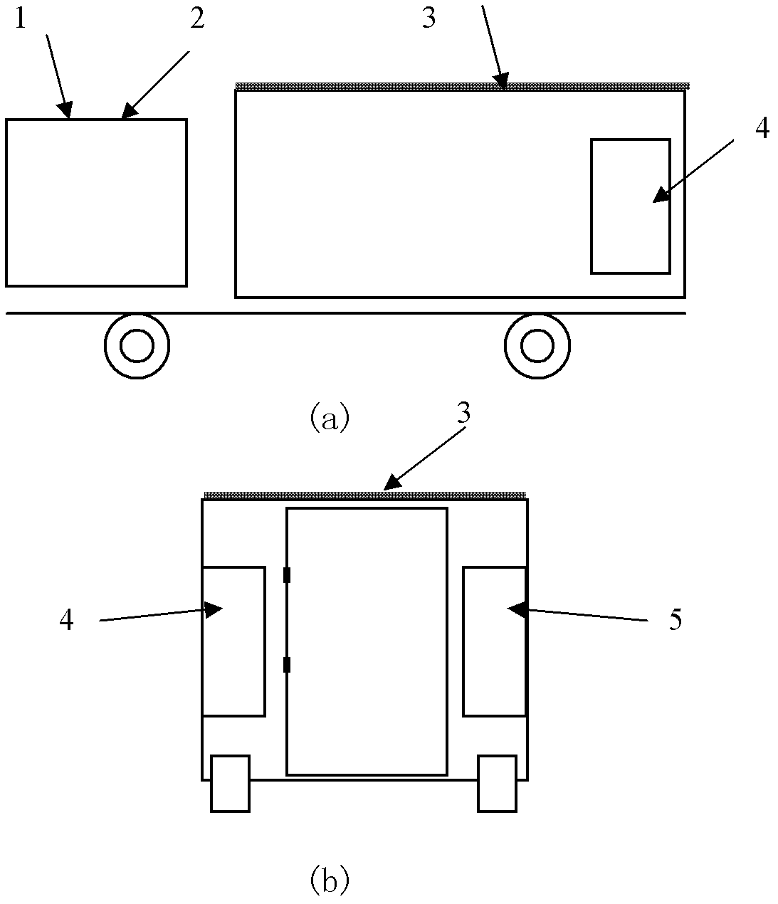
[0068] The calibration equipment vehicle used for remote sensing calibration experiments of unmanned aerial vehicles of the present invention is a large van, including a vehicle body, a calibration equipment system, a roof coating / installation geometric resolution plate and / or radiation and / or spectrum Real-time joint processing system for target and space-earth calibration data, ground experiment command and flight information feedback system. The following is a detailed introduction:

[0069] (1) Calibration equipment system

[0070] According to the needs of remote sensing calibration experiments, the body of the calibration equipment vehicle is equipped with 1) Meteorological observation instrument 2) Sun photometer 3) GPS receiver 4) Canopy analyzer, microwave scatterometer and auxiliary equipment, handheld plant canopy infrared temperature measurement instrument, electronic precision balance, soil moisture meter, compass 5) spectrometer and multi-angle measuring device,...


PUM


Abstract

The invention relates to a remote sensing calibration comprehensive method and a calibration equipment vehicle. According to the invention, calibration equipment is integrated into a vehicle-mounted system; a novel mobile target is established to perform the far-field quick calibration and the optical spectrum and radiation resolution combined calibration; the differences on aspects of optical spectrum, radiation and geometry between a hard target and a conventional soft target on a remote-sensing image are analyzed through comparison of different time phases, so as to establish a performance degradation compensation model for the soft target to realize correction calibration; an information receiving device equipped on a vehicle body can receive videos of aircrafts in the air and acquired ground data so as to realize four-resolution combined calibration of geometric distortion and time phase data and the optical spectrum and radiation data of the vehicle body based on wireless transmission; the status of unknown remote sensing calibration results and delayed data processing in the past can be changed through analysis and processing by high-performance computers; a set of ground experiment remote control and flight information feedback communication link is established, and the difficult situation of difficulty in information interaction among the air, the ground and command center, and out-field workstations is changed.

Description

technical field [0001] The invention relates to the field of aircraft remote sensing imaging, and relates to a remote sensing calibration synthesis method, in particular to an aircraft, especially a remote sensing calibration synthesis method for aviation and unmanned aircraft, and a calibration device for remote sensing calibration car. Background technique [0002] With the gradual deepening of the application of remote sensing technology in various fields, the quantification of remote sensing data has become an inevitable trend in the further development of remote sensing technology. [0003] Under the guarantee of geometric calibration of remote sensing sensors (such as space cameras), radiation and spectral calibration technologies have become the deepening of their quantitative applications. Radiation calibration is the process of establishing the relationship between the radiation amount at the entrance pupil of the space camera and the detector output DN (Digital Nu...

Claims


Application Information

Patent Timeline
Patent Type & Authority Applications(China)
IPC IPC(8): G01C25/00
Inventor 晏磊勾志阳段依妮赵炳爱陈伟聂志彪王明志赵海盟相云杨彬路琪
Owner PEKING UNIV
Why Eureka
Try Eureka