Method and system for locating underwater vehicle on basis of global navigation satellite system (GNSS) satellite

A technology for underwater vehicles and positioning methods, applied in satellite radio beacon positioning systems, radio wave measurement systems, instruments, etc., can solve the problem that GNSS cannot directly meet the needs of underwater navigation and positioning, and satellite positioning and navigation technology failures, etc. question

Inactive Publication Date: 2012-07-25
GUILIN UNIV OF ELECTRONIC TECH
View PDF3 Cites 37 Cited by
  • Summary
  • Abstract
  • Description
  • Claims
  • Application Information

AI Technical Summary

Problems solved by technology

However, radio waves cannot penetrate water, especially seawater. All satellite positioning and navigation technologies "failure" inside the ocean water body, and underwater has become a "blind spot" for GNSS
Therefore, GNSS cannot directly meet the needs of underwater navigation and positioning of rivers, lakes, oceans, etc.

Method used


Image

  • Method and system for locating underwater vehicle on basis of global navigation satellite system (GNSS) satellite
  • Method and system for locating underwater vehicle on basis of global navigation satellite system (GNSS) satellite
  • Method and system for locating underwater vehicle on basis of global navigation satellite system (GNSS) satellite

Examples


Embodiment Construction

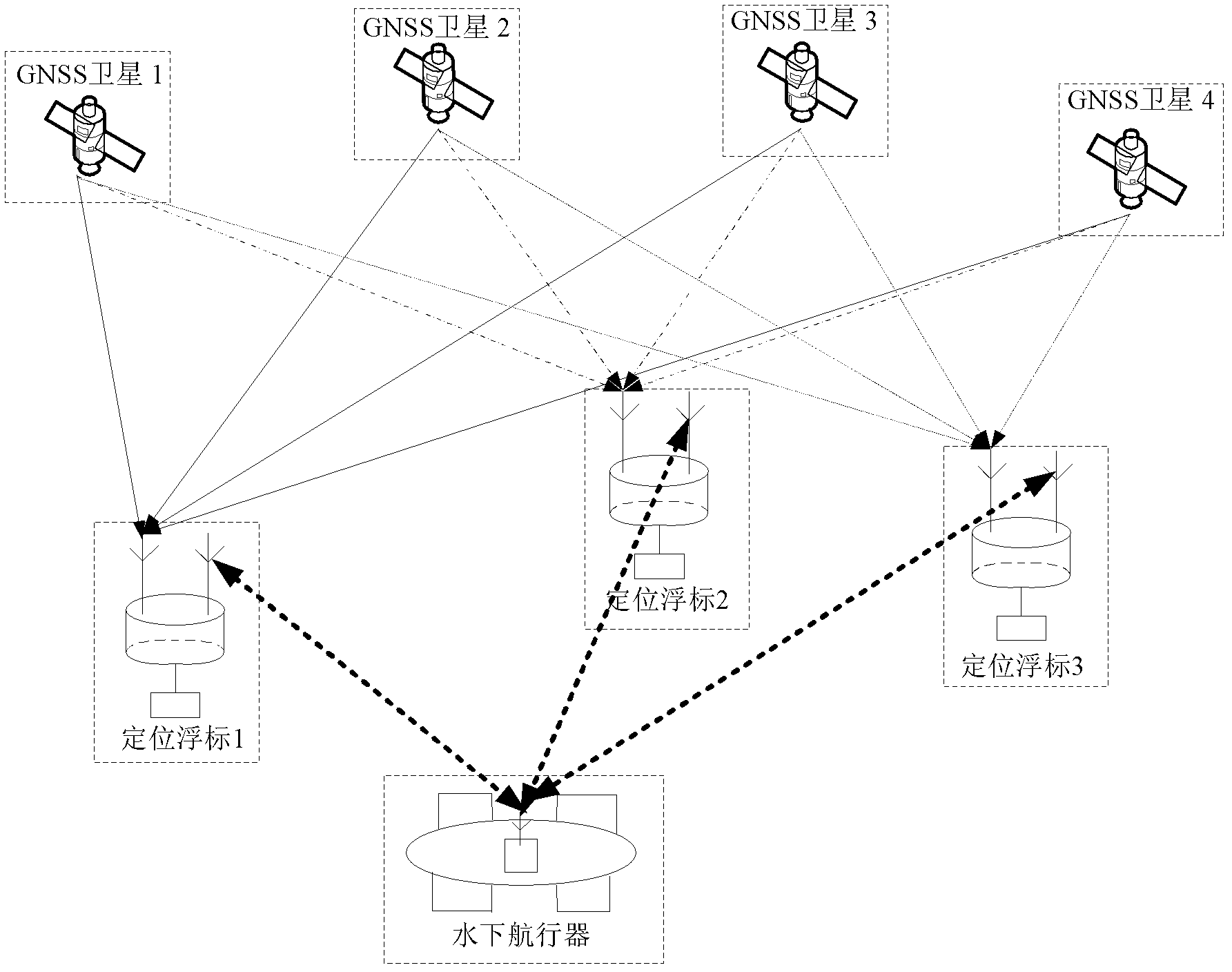
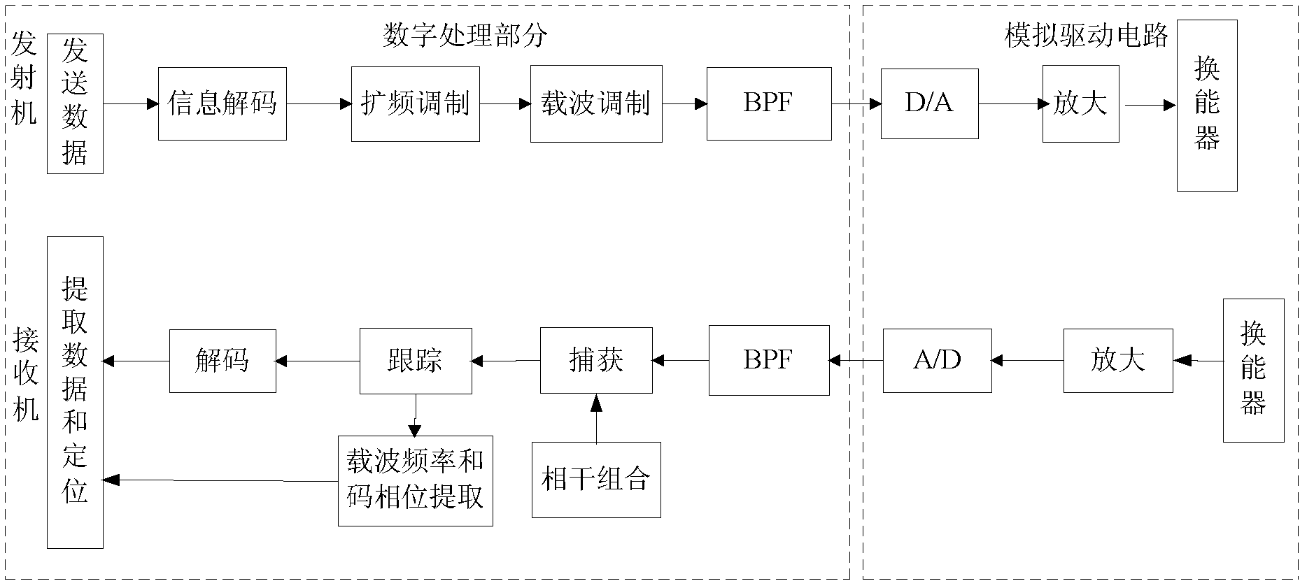
[0046] see figure 1 According to the present invention, a GNSS satellite-based underwater vehicle positioning system mainly consists of at least 3 GNSS satellites, at least 3 positioning buoys arranged on the water surface, and an underwater vehicle. The positioning buoy carries a GNSS receiver and a hydroacoustic transponder, the receiving end of the GNSS receiver is connected to the GNSS satellite, and the output end of the GNSS receiver is connected to the input end of the hydroacoustic transponder. The above-mentioned GNSS receiver receives the satellite signals played by 3 or more GNSS, completes the positioning and timing of the positioning buoy in real time, and sends the positioning and timing information to the underwater acoustic transponder. After receiving the question-and-answer signal from the underwater vehicle, the above-mentioned underwater acoustic transponder encodes and modulates the positioning and timing information into a response signal, and converts th...


PUM


Abstract

The invention discloses a method and a system for locating an underwater vehicle on basis of a global navigation satellite system (GNSS) satellite, wherein a plurality of locating buoys are additionally arranged on the water and carry GNSS receivers and underwater sound responders. The underwater vehicle carries the underwater sound responder. The locating buoys utilize a GNSS satellite location technique to complete self location and time service. When the underwater vehicle is needed to be located, the inquiry signal which is sent out by the underwater sound responder on the underwater vehicle is responded by the underwater responders on the locating buoys and then returns to the underwater responder. When the underwater vehicle simultaneously obtains at least 3 locating buoys which are distributed on the water and a certain resolving relation, the three-dimensional location coordinates of the underwater vehicle can be finally obtained. An underwater sound relative locating technology can be utilized to expand the GNSS water level precision locating capability towards underwater, so the underwater vehicle can directly obtain the self geodetic longitude and latitude coordinates at an operating submerged depth, and the locating precision is enabled to be at the same order of the GNSS water level locating precision.

Description

technical field [0001] The invention relates to the field of underwater vehicle positioning, in particular to a GNSS satellite-based underwater vehicle positioning method and system. Background technique [0002] Underwater vehicles sometimes need to sail for a long time at a certain sea depth, but due to the limitations of current positioning means and positioning equipment for underwater vehicles, the vehicle must float up to correct its position after sailing for a period of time. At present, the aircraft is mainly positioned by the integrated underwater positioning method based on inertial navigation. Due to the influence of the cumulative error of the inertial navigation system, it must float to the water surface to correct its position after sailing for a period of time, which seriously damages its normal work. . Therefore, underwater autonomous fast and accurate absolute positioning of underwater vehicles has always been a worldwide problem. [0003] The GNSS satell...

Claims


Application Information

Patent Timeline
Patent Type & Authority Applications(China)
IPC IPC(8): G01S19/48G01S19/31G01S15/06
Inventor 孙希延纪元法符强王守华严素清邓洪高吴孙勇张瑞霞
Owner GUILIN UNIV OF ELECTRONIC TECH
Why Eureka
Try Eureka