Method for simplifying shoreline of drowned valley by taking geographical features into account

A technology of geographical features and coastlines, applied in image data processing, instruments, graphics and image conversion, etc., can solve the problems of not being able to correctly reflect the geographical features of the coastline mapping area, ignoring analysis and processing, etc.

Inactive Publication Date: 2012-07-25
WUHAN UNIV
View PDF1 Cites 21 Cited by
  • Summary
  • Abstract
  • Description
  • Claims
  • Application Information

AI Technical Summary

Problems solved by technology

The existing methods regard the coastline as a purely geometric element, aiming at maintaining geometric features (such as feature points or main body trends, etc.), ignoring the analysis and processing of the geographical meaning behind the geometric features, and cannot correctly reflect the coastline. The geographic feature of the cartographic area where the line falls

Method used


Image

  • Method for simplifying shoreline of drowned valley by taking geographical features into account
  • Method for simplifying shoreline of drowned valley by taking geographical features into account
  • Method for simplifying shoreline of drowned valley by taking geographical features into account

Examples


Embodiment

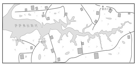
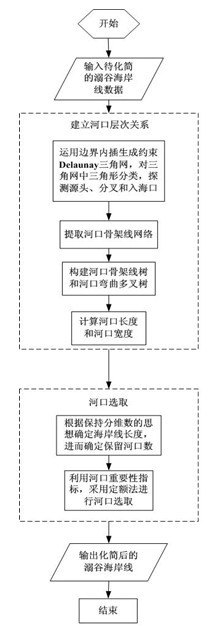
[0065] The specific implementation of the method for simplification of the drowned valley coastline in consideration of geographical features of the present invention will be described in detail below in conjunction with the accompanying drawings.

[0066] Depend on figure 2 Given, the present invention is realized through the following steps:

[0067] 1. Based on the constrained Delaunay triangulation, establish the hierarchical relationship of the estuary.

[0068] 1) Detect sources, bifurcations and estuaries.

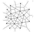
[0069] (1) Deluanay triangular network

[0070] Delaunay triangulation is a triangular network that connects discrete point sets in the plane according to optimization principles (that is, uniqueness, minimum angle maximum characteristics and empty circle characteristics principles). It was proposed by Russian mathematician Delaunay in 1935 and proved that the The sum of the smallest interior angles of all triangles in the network is the largest.

[0071] Delau...


PUM


Abstract

The invention relates to a method for simplifying a shoreline of a drowned valley, in particular to a method for simplifying the shoreline of the drowned valley by taking geographical features into account. The method comprises the following steps: (1) establishing a hierarchical relationship of river mouths of the shoreline of the drowned valley based on a Delaunay triangular network, and calculating the length and width of the river mouth; and (2) designing an important index of the river mouth based on this basis, deducing the number of selected river mouths without changing the shoreline fractal dimension, and selecting the river mouths by adopting a quota method so as to realize shoreline simplification through the river mouth selection. According to the method for simplifying the shoreline of the drowned valley by taking geographical features into account, the important geographical characteristics, such as a tree-shaped structure, a river mouth hierarchical structure and gradual changes of the individual width of the river mouth of the shoreline of the drowned valley and the like can be maintained, and the topological consistency of the simplifying result and the sailing safety are guaranteed.

Description

technical field [0001] The invention relates to a method for simplifying the coastline of a drowning valley, in particular to a method for simplifying a coastline of a drowning valley in consideration of geographical features. Background technique [0002] As an important element of the coastline on nautical charts and island reef maps, its correct expression and effective simplification in the comprehensive scale transformation of the map are of great significance for navigation safety, coastal zone environmental analysis, and military strategic analysis. In the establishment of the "digital ocean" information technology system, it is often necessary to implement multi-scale and multi-resolution representations of coastal elements to meet the needs of data integration and adaptive visualization of cross-scale islands and reefs. The realization of this technology also requires the automatic simplification of coastlines. support. [0003] The earliest coastline simplificatio...

Claims


Application Information

Patent Timeline
Patent Type & Authority Applications(China)
IPC IPC(8): G06T3/00
Inventor 艾廷华张翔李精忠田晶杨敏
Owner WUHAN UNIV
Why Eureka
Try Eureka