Hyper-spectral remote sensing image mixed pixel decomposition method based on distance geometry theory

A technology of hyperspectral remote sensing and image mixing, which is applied in the field of high-mixed remote sensing data mixed pixel decomposition, and can solve the problems of remote sensing classification and area measurement accuracy that are difficult to meet practical requirements.

Inactive Publication Date: 2012-07-25
FUDAN UNIV
View PDF5 Cites 11 Cited by
  • Summary
  • Abstract
  • Description
  • Claims
  • Application Information

AI Technical Summary

Problems solved by technology

Mixed pixels widely exist in hyperspectral remote sensing images, which makes it difficult for traditional pixel-level hyperspectral remote sensing image applications, such as remote sensing classification and area measurement accuracy, to meet practical requirements

Method used


Image

  • Hyper-spectral remote sensing image mixed pixel decomposition method based on distance geometry theory
  • Hyper-spectral remote sensing image mixed pixel decomposition method based on distance geometry theory
  • Hyper-spectral remote sensing image mixed pixel decomposition method based on distance geometry theory

Examples


Embodiment Construction

[0104] Below, the specific embodiment of the present invention is illustrated with simulation data and actual remote sensing image data respectively:

[0105] 1. Simulation data

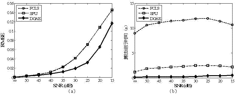
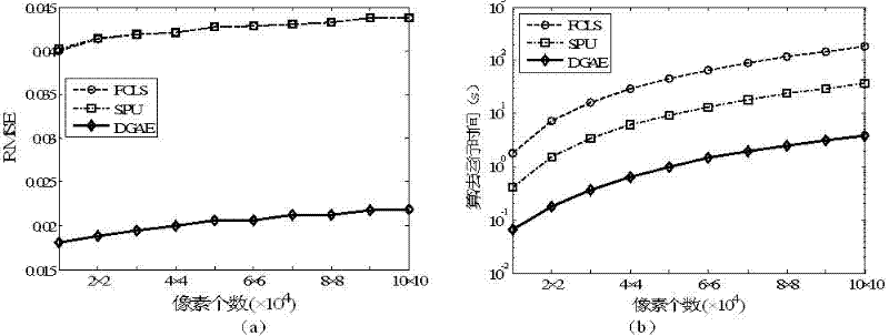
[0106] In this section, we employ simulated data to test the performance of the algorithm. Compare the algorithm proposed by the present invention with two similar algorithms: FCLS [11] and SPU [12], wherein, the former is a kind of abundance estimation algorithm widely used at present, and the latter is a newly proposed one Algorithms with better performance. We comprehensively evaluate the performance of these three algorithms by analyzing the results of abundance estimation and algorithm execution time.

[0107] The Root Mean Square Error (RMSE) was used to measure the quality of the abundance estimation results. It characterizes how close the abundance unmixing result is to the true abundance. Assume that the endmember abundance matrix obtained by the abundance estimation algorithm is , t...


PUM


Abstract

The invention belongs to the technical field of remote sensing image processing and particularly relates to a hyper-spectral remote sensing image mixed pixel decomposition method based on a distance geometry theory. The invention provides an operational formula for calculating an areal coordinate of a high-dimensional data space by introducing the distance geometry theory into a hyper-spectral remote sensing image mixed pixel according to physical characteristics of a hyper-spectral image and geometric characteristics of a data set, and obtains a position estimation algorithm which can well keep a geometric structure of the data set according to a distance geometric constraint; and finally, a novel high-precision and low-complexity abundance estimation algorithm, namely the abundance estimation algorithm based on a distance geometry, is obtained. The algorithm has good applicability to various different hyper-spectral data (including emulated data and actual data sets). The hyper-spectral remote sensing image mixed pixel decomposition method based on the distance geometry theory, disclosed by the invention, has very important application value on aspects of high-precision ground feature classification of multispectral and hyper-spectral remote sensing images, and detection and identification of a ground target.

Description

technical field [0001] The invention belongs to the technical field of remote sensing image processing, and in particular relates to a method based on distance geometry theory to solve the problem of high mixed remote sensing data mixed pixel decomposition. Background technique [0002] Remote sensing is a new comprehensive technology developed in the 1960s. It is closely related to science and technology such as space, electron optics, computer, and geography. It is one of the most powerful technical means for studying the earth's resources and environment. In recent years, with the development of hyperspectral imaging technology, hyperspectral remote sensing has become a rapidly developing branch of remote sensing. As a multi-dimensional information acquisition technology, it combines imaging technology and spectral technology to simultaneously acquire information in tens to hundreds of very narrow and continuous spectral intervals of the electromagnetic spectrum, thereby ...

Claims


Application Information

Patent Timeline
IPC IPC(8): G06T7/00
Inventor 普晗晔王斌张立明
Owner FUDAN UNIV
Why Eureka
Try Eureka