Auxiliary positioning method for mobile phones based on magnetic field sensor and electronic map

A magnetic field sensor and electronic map technology, applied in location information-based services, ground navigation, etc., can solve problems such as unusable, high dependence on GPS signals and base station signals, etc.

Inactive Publication Date: 2012-08-22
SHENZHEN GIONEE COMM EQUIP
View PDF0 Cites 7 Cited by
  • Summary
  • Abstract
  • Description
  • Claims
  • Application Information

AI Technical Summary

Problems solved by technology

[0002] At present, the positioning methods used on mobile phones include GPS positioning and mobile phone base station positioning. These two positioning methods rely heavily on GPS signals and base station signals, and cannot be used when there is no signal or the signal is very weak.

Method used


Image

  • Auxiliary positioning method for mobile phones based on magnetic field sensor and electronic map
  • Auxiliary positioning method for mobile phones based on magnetic field sensor and electronic map
  • Auxiliary positioning method for mobile phones based on magnetic field sensor and electronic map

Examples


Embodiment Construction

[0018] In order to illustrate the idea and purpose of the present invention, the present invention will be further described below in conjunction with the accompanying drawings and specific embodiments.

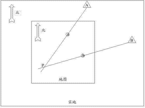
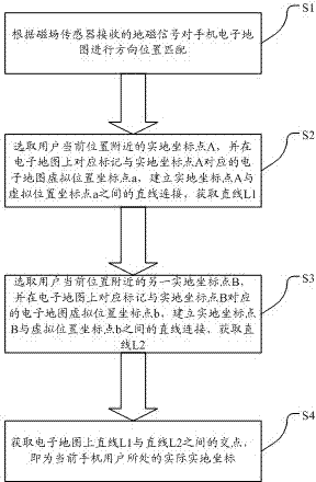
[0019] The invention provides a method for assisting positioning of a mobile phone based on a magnetic field sensor and an electronic map, which mainly uses the combination of the electronic map and the geomagnetic sensor of the mobile phone, and uses the intersection generated by the actual coordinate positioning to form a scale reduction corresponding to the actual coordinate map, and Displayed on the electronic map of the mobile phone, the corresponding intersection point displayed on the electronic map of the mobile phone is the coordinates of the user's actual location, and the user can know the current location through the name and location marked on the electronic map.

[0020] See figure 1 , figure 2 as shown, figure 1 It is a schematic diagram of the positioning s...


PUM


Abstract

The invention discloses an auxiliary positioning method for mobile phones based on a magnetic field sensor and an electronic map. A mobile phone electronic map is combined with a mobile phone magnetic field sensor so as to enable the position orientation where the mobile phone electronic map is correspondingly located to be identical with the north-south orientation of actual earth magnetism, and electronic map virtual coordinates are utilized to establish straight line connection with on-site coordinates in actual regions, and cross points generated among different practical coordinates are displayed on the electronic map correspondingly, so as to enable a user to be capable of knowing the currently actual coordinates through the electronic map. Compared with the prior art, according to the method, GPS (Global Positioning system) positioning and mobile phone base station positioning are not required, the situation that the current position information can not be searched by a GPS or a base station under the conditions of weak or no signals can be avoided, and the problem that the mobile phone can not be accurately positioned is solved.

Description

technical field [0001] The invention belongs to mobile phone positioning technology, and specifically relates to a method for assisting positioning of a mobile phone based on a magnetic field sensor and an electronic map, so as to solve the problem of positioning the mobile phone when there is no GPS signal and a base station signal or the signal is weak. Background technique [0002] At present, the positioning methods used on mobile phones include GPS positioning and mobile phone base station positioning. These two positioning methods are highly dependent on GPS signals and base station signals, and cannot be used when there is no signal or the signal is very weak. [0003] Now, the application of magnetic field sensors and electronic maps on mobile phones is quite common. How to combine the two to achieve easy positioning is a problem that needs to be solved at present. Contents of the invention [0004] For this reason, the object of the present invention is to provide...

Claims


Application Information

Patent Timeline
Patent Type & Authority Applications(China)
IPC IPC(8): H04W4/02G01C21/08
Inventor 曲大伟
Owner SHENZHEN GIONEE COMM EQUIP
Why Eureka
Try Eureka