Navigation method of universal airplane aircraft route

A navigation method and route technology, applied in the field of aircraft route navigation, can solve problems such as inability to accurately fly guidance and navigation, and achieve the effects of enhanced autonomous control, intuitive display, and wide range of tasks

Inactive Publication Date: 2012-12-19
AVIC NO 631 RES INST
View PDF5 Cites 6 Cited by
  • Summary
  • Abstract
  • Description
  • Claims
  • Application Information

AI Technical Summary

Problems solved by technology

[0004] The present invention provides a navigation method for a general aircraft route to solve the problem that pilots in the prior art cannot autonomously and intuitively understand and grasp the deviation between the current flight direction and the preset course or planned route, and cannot accurately conduct flight guidance and navigation question

Method used


Image

  • Navigation method of universal airplane aircraft route

Examples


Embodiment 1

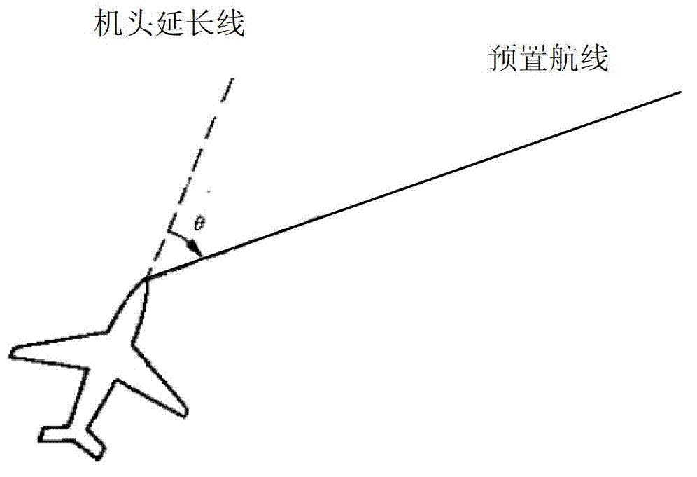
[0021] Embodiment 1: Based on the navigation information of the ground navigation station, the navigation indication of the nose extension line is constructed.

[0022] The aircraft flies along the preset route under the guidance of the ground navigation station. The on-board navigation equipment receives the ground navigation information, calculates the ground navigation information and the current flight direction of the aircraft, and constructs the navigation mode of the extension line of the aircraft nose. Under the independent control of the pilot, The angle and flight direction are displayed in the auxiliary navigation screen, and the pilot can fly along the preset route according to the navigation information of the ground navigation station, such as radio compass, omnidirectional beacon, etc. In the supported state, the aircraft nose extension line navigation indication technology of the present invention can be used as an auxiliary navigation mode to provide the pilot ...

Embodiment 2

[0023] Embodiment 2: Based on the GPS information, the navigation instruction of the nose extension line is constructed.

[0024] General-purpose aircraft are flexible in use, have diverse tasks, and changeable flight areas. It is necessary to perform preset flight routes without the support of ground navigation stations. The onboard navigation equipment cannot provide comprehensive navigation information. Under this condition, the airborne navigation equipment can receive GPS information in the air, calculate the current aircraft position information, and use the preset route as a reference to construct the navigation indication method of the aircraft nose extension line. Under the pilot's autonomous control, the angle, angle, The flight direction display guides the aircraft to fly along the preset route. In this state, the nose extension line navigation indication technology of the present invention becomes the main navigation guidance method, providing pilots with accurate,...


PUM


Abstract

The invention provides a navigation method of a universal airplane aircraft route to solve the technical problems that a pilot cannot autonomously and intuitively know and grasp deviation between a current flight direction and a preset flight direction or planned flight course and cannot accurately carry out flight guide and navigation in the prior art. The navigation method comprises the steps as follows: airborne navigation equipment sets a preset route as a reference route, takes position information of a territorial navigation station and present position information of the airplane as reference information, calculates current airplane position and flight direction in real time, and calculates out the angle difference of an extension line of a nose direction and the reference route; the reference route and the prolonging line of the handpiece direction are displayed on a navigation map interface for prompting the pilot to operate and guide the airplane to fly along the preset route accurately. The technical scheme is convenient to carry out, safe and reliable, visual and clear in display mode, not only can be applied to universal airplane navigation indication, but also can be applied to various airplanes. The flight navigation indication method is enriched and completed.

Description

technical field [0001] The invention relates to an aircraft route navigation method, which is especially suitable for general aircraft navigation. Background technique [0002] The currently commonly used aircraft route navigation methods include automatic directional navigation, omnidirectional beacon navigation, radio ranging navigation, GPS navigation and other single navigation methods or combined navigation methods, all of which use the position of the fixed navigation station on the ground as a reference , take the connection between the aircraft and the current navigation station as the termination point, and calculate the angle between the two for flight navigation. For example, the radio compass uses the relative azimuth from the aircraft to the ground radio navigation station to indicate navigation; omnidirectional beacon The angle between the plane and the ground navigation station is measured clockwise from the magnetic north direction of the plane to indicate th...

Claims


Application Information

Patent Timeline
Patent Type & Authority Applications(China)
IPC IPC(8): G01C21/00G01C21/22
Inventor 孔翔李文军缪炜涛
Owner AVIC NO 631 RES INST
Why Eureka
Try Eureka