Geomagnetic aided inertial navigation method

An inertial navigation and geomagnetic technology, applied in the fields of navigation, geomagnetic-assisted inertial navigation, and guidance, can solve the problems of large amount of noise reduction and matching calculation, reduce matching rate, and affect matching accuracy, so as to save precise matching time and eliminate sensitive factors. , Improve the effect of noise reduction efficiency

Inactive Publication Date: 2012-12-19
BINZHOU UNIV
View PDF1 Cites 11 Cited by
  • Summary
  • Abstract
  • Description
  • Claims
  • Application Information

AI Technical Summary

Problems solved by technology

This kind of algorithm not only takes a long time, but also has poor real-time performance, and is easily disturbed by noise.
[0006] In the existing technology, the method of inertial geomagnetic navigation using the matching of the measured geomagnetic information and the geomagnetic map is to firstly perform noise reduction processing on the measured geomagnetic information, and then use a single matching algorithm for separate matching navigation or use two matching algorithms Carry out joint matching navigation. Compared with the inertial geomagnetic navigation method that only uses geomagnetic information, the navigation accuracy has been improved to a certain extent. However, this navigation method directly performs noise reduction processing on the current measured geomagnetic information of the carrier. The amount of information is large, and the amount of matching information is large, so the calculation of noise reduction and matching is large, which greatly increases the matching strength, reduces the matching rate, and also affects the matching accuracy.

Method used


Image

  • Geomagnetic aided inertial navigation method
  • Geomagnetic aided inertial navigation method
  • Geomagnetic aided inertial navigation method

Examples


Embodiment Construction

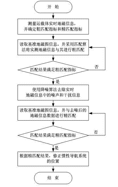
[0029] In order to clearly illustrate the technical features of the solution, the solution will be described below through a specific implementation mode combined with the accompanying drawings.

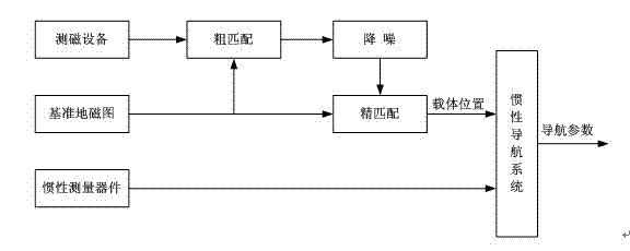
[0030] as attached figure 1 and 2 Shown, concrete method of the present invention is as follows:

[0031] (1) Obtain the real-time geomagnetic information of the current position of the carrier through the magnetic measuring equipment, and determine the rough matching index and the fine matching index.

[0032] In order to facilitate the description of the implementation process of the present invention, in this embodiment, two identical magnetic measuring devices are selected for simultaneous measurement, and here the rough matching index is set to 10%, and the fine matching index is set to 0.5%. The rough matching index and the fine matching index can be adjusted according to specific situations in practical applications.

[0033] In order to implement the solution of the presen...


PUM


Abstract

The invention relates to the navigation and guidance technologies and provides a technical scheme of a geomagnetic aided inertial navigation method. According to the scheme, at least more than one magnetic measuring apparatus is used for simultaneously measuring real-time geomagnetic information of transporters; and a geomagnetic matching navigation mode is adopted to conduct rough matching, noise reduction and precise matching on the measured real-time geomagnetic information sequentially. The magnetic measuring manner reduces the error of the apparatus and ensures the reliability of the measured value. By adopting the matching mode, the non-matching points with the reference geomagnetic map are eliminated and the range of the noise reduction and the precise matching is reduced, thereby improving the noise reduction efficiency of the real-time geomagnetic information and saving the precise matching time of the non-matching points; and meanwhile, the speed of the precise matching is improved and the precision of the navigation is ensured, thereby further promoting the quality of the geomagnetic aided inertial navigation.

Description

technical field [0001] The invention relates to navigation and guidance technology, in particular to the technical field of autonomous navigation of aircraft, in particular to a geomagnetism-assisted inertial navigation method. Background technique [0002] At present, inertial navigation is one of the main ways of navigation and positioning. It can autonomously and covertly carry out continuous three-dimensional space positioning and three-dimensional space orientation under all-weather conditions, on a global scale and in any medium environment, without any external aids. Information does not radiate any information to the outside, and can provide a variety of complete navigation parameters completely autonomously. It is widely used in many fields, but its navigation error will continue to accumulate over time, and it is not suitable for long-term independent navigation. [0003] In view of the above technical problems, there is currently a method of using the earth's inhe...

Claims


Application Information

Patent Timeline
Patent Type & Authority Applications(China)
IPC IPC(8): G01C21/16G01C21/08
Inventor 柳明王海军高斌毛国强
Owner BINZHOU UNIV
Why Eureka
Try Eureka