Optimized design method of regional crop evapotranspiration spatial-temporal pattern
A crop and water consumption technology, applied in computing, special data processing applications, instruments, etc., can solve the problems of less research on regional crop water consumption spatio-temporal optimization
- Summary
- Abstract
- Description
- Claims
- Application Information
AI Technical Summary
Problems solved by technology
Method used
Image
Examples
Embodiment Construction
[0033] The preferred embodiments will be described in detail below in conjunction with the accompanying drawings. It should be emphasized that the following description is only exemplary and not intended to limit the scope of the invention and its application.
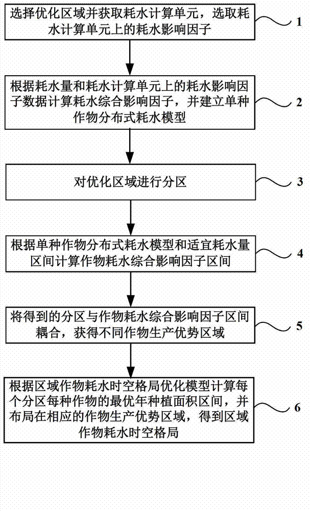
[0034] figure 1 It is a flow chart of the optimal design method for the spatio-temporal pattern of regional crop water consumption. Such as figure 1 Shown, the method provided by the invention comprises:
[0035] Step 1: Select the optimization area and obtain the water consumption calculation unit, and select the water consumption impact factor on the water consumption calculation unit.
[0036] Select the optimized area and call the digital elevation model (Digital elevation model, DEM), crop spatial distribution map, climate data, soil distribution map and crop water consumption data of the optimized area. From the DEM data in the system, micro-topographic factor data such as slope, aspect, and slope length are ...
PUM
 Abstract
Description
Claims
Application Information
 - R&D
- Intellectual Property
- Life Sciences
- Materials
- Tech Scout
- Unparalleled Data Quality
- Higher Quality Content
- 60% Fewer Hallucinations
Browse by: Latest US Patents, China's latest patents, Technical Efficacy Thesaurus, Application Domain, Technology Topic, Popular Technical Reports.
© 2025 PatSnap. All rights reserved.Legal|Privacy policy|Modern Slavery Act Transparency Statement|Sitemap|About US| Contact US: help@patsnap.com


