Parallel digital terrain analysis-oriented massive DEM (Digital Elevation Model) deploying and scheduling method

A technology of digital terrain and scheduling method, applied in resource allocation, multi-program device, etc., can solve the problems of low-efficiency management and scheduling of DEM, achieve good feasibility and stability, improve computing efficiency, and high portability Effect

Inactive Publication Date: 2013-01-30
NANJING NORMAL UNIVERSITY
View PDF2 Cites 8 Cited by
  • Summary
  • Abstract
  • Description
  • Claims
  • Application Information

AI Technical Summary

Problems solved by technology

The technical process covers two key technical links: adaptive computing node performance data distribution technology and load-balanced reachable grid DEM data sch...

Method used


Image

  • Parallel digital terrain analysis-oriented massive DEM (Digital Elevation Model) deploying and scheduling method
  • Parallel digital terrain analysis-oriented massive DEM (Digital Elevation Model) deploying and scheduling method
  • Parallel digital terrain analysis-oriented massive DEM (Digital Elevation Model) deploying and scheduling method

Examples


Embodiment Construction

[0029] The present invention will be described in further detail below in conjunction with the accompanying drawings and specific examples.

[0030] The main classes and interfaces in the design and implementation process of the present invention are shown in Table 1.

[0031] Table 1 Main classes and functions

[0032]

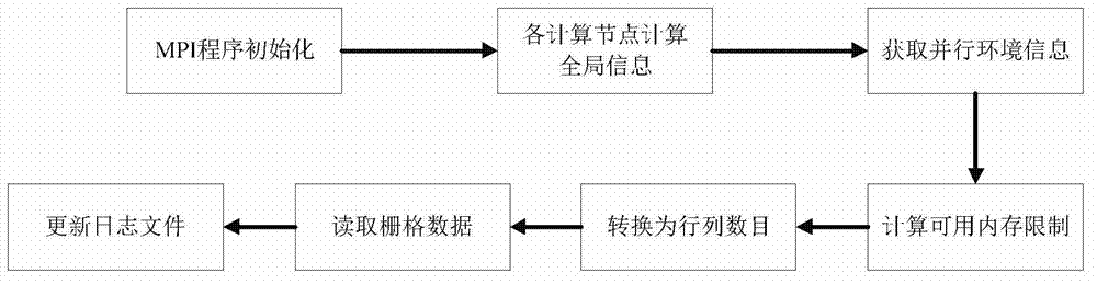
[0033] The first step, the initialization of parallel application program: the present invention has designed the parallel application program initialization operation for various grid digital elevation models (see figure 1 ). Through this initialization workflow, each computing node can obtain various parameters of the parallel computing environment and DEM at the same time.

[0034] The specific implementation process of parallel application initialization is:

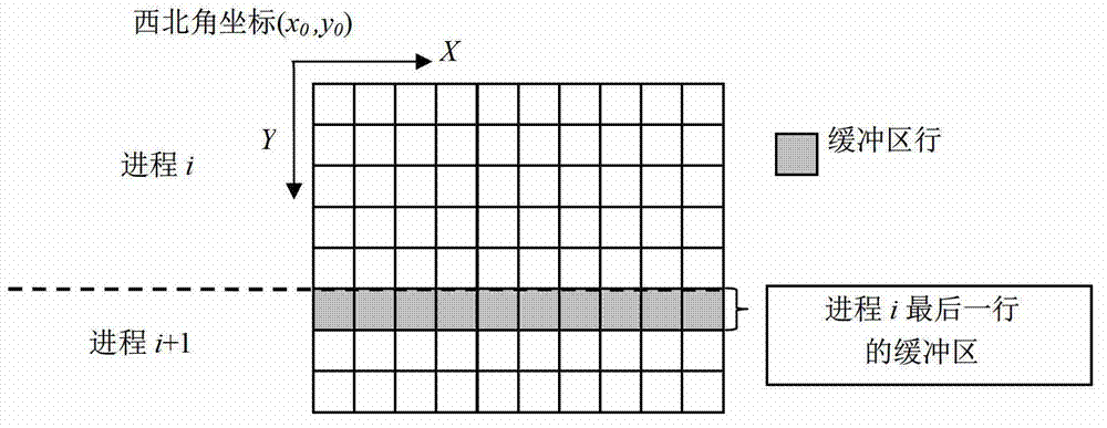
[0035] (1.a) Enter the MPI environment, and each process reads various information of the global DEM and the parallel environment, such as: the X and Y coordinates of the upper left corner of ...


PUM


Abstract

The invention discloses a parallel digital terrain analysis-oriented massive DEM (Digital Elevation Model) deploying and scheduling method which comprises the following steps of: firstly, initializing a parallel application program, simultaneously obtaining parallel computing environments and various parameters of a DEM by all computing nodes; secondly, executing a serial algorithm by all computing nodes according to a local data block and a buffer region, updating corresponding data of the buffer region if necessary; thirdly, scheduling a parallel computing granular control module for counting and updating granularities of data computed in parallel until the parallel computing efficiency is optimal; and fourth, generating a result file, to be specific, recycling various memories applied by a parallel terrain analysis application, clearing temporary memories and irrelevant external memory data, updating a journal file, counting and recording time of all nodes executing different operations every time so as to bring the convenience for repeated execution of the terrain analysis algorithm, carrying out result fusion and post-operation, and finally outputting the result file. The parallel digital terrain analysis-oriented massive DEM deploying and scheduling method has a wide industrial application prospect.

Description

technical field [0001] The invention relates to a method for managing and dispatching massive digital elevation model data, specifically, a dynamic data distribution and deployment method based on a distributed parallel digital terrain analysis technology and a data parallel computing model. Background technique [0002] Digital Terrain Analysis is a digital information processing technology that performs terrain attribute calculation and feature extraction on a digital elevation model (DEM). Since the 1960s, digital terrain analysis has been widely used in geoscience fields such as cartography, civil engineering, water conservancy, transportation, hydrology, agriculture, and planning. With the deepening of research and the expansion of application fields, various application fields have put forward new requirements for digital terrain analysis. At the same time, the emergence of various new sensors, such as LiDAR, InSAR, SAR, etc., makes DEM more flexible and rapid in data...

Claims


Application Information

Patent Timeline
IPC IPC(8): G06F9/50
Inventor 刘学军汤国安宋效东江岭
Owner NANJING NORMAL UNIVERSITY
Why Eureka
Try Eureka