Land utilization data update method based on space aggregation

A data update and land technology, applied in the direction of electrical digital data processing, special data processing applications, instruments, etc., can solve problems such as difficulty in ensuring consistency of land use data, inconsistency of land use data, difficulty in updating land use data, etc., to achieve Save data storage space, reduce linkage change types, and improve operation efficiency

Active Publication Date: 2013-01-30
ZHEJIANG UNIV
View PDF2 Cites 5 Cited by
  • Summary
  • Abstract
  • Description
  • Claims
  • Application Information

AI Technical Summary

Problems solved by technology

[0004] 1. When the change operation caused by the change of the administrative area or the change of the parcel is performed, the parcel layer, boundary line layer, boundary point layer, administrative area layer, administrative area boundary layer, sporadic feature layer, linear feature layer, The change of multiple layers such as the patch layer of the land type map and the land type boundary layer invo

Method used


Image

  • Land utilization data update method based on space aggregation
  • Land utilization data update method based on space aggregation

Examples


Embodiment

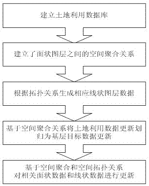
[0039] 1. According to the "Standard for land use database" released in the second national land survey Utilize databases, including current and historical databases. The data structure of the current database is the same as that of the historical database. The current database stores the current data, and the historical database only stores the data replaced by the changed data. Among them, the parcel layer, boundary line layer, administrative area layer, and administrative area boundary layer do not need to be established.

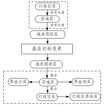
[0040] 2. Reorganize the land use data through the spatial aggregation method, and establish the spatial aggregation gate between the planar layers: the parcels are obtained by the aggregation of land-type map blocks with the same ownership, and the administrative districts are obtained by the aggregation of the same ownership Obtained by parcel aggregation.

[0041] 3. Generate linear layer data corresponding to each planar layer according to the spat...


PUM


Abstract

The invention discloses a land utilization data update method based on space aggregation. The method includes reorganizing land utilization data through a space aggregation method, establishing space aggregation relations among planar layers, and generating data of linear layers corresponding to the planar layers according to space topological relations; allocating the update of land utilization data to the update of base target data based on the space aggregation relations among planar layers of the land utilization data; and updating land utilization upper-layer planar data and linear data through the space aggregation relations and the space topological relations after the update of the base target data. The land utilization data update method based on space aggregation simplifies the update of the land utilization data, guarantees the integrity and the cohesiveness of the land utilization data, updates the land utilization data rapidly, and has significant practical significances for establishing land utilization dynamic monitoring and strengthening land management.

Description

technical field [0001] The invention relates to a method for updating land use data based on spatial aggregation. The invention belongs to the technical field of land use data organization and updating. Background technique [0002] The land use database is constantly updated as time changes. In order to ensure the current situation of land use data, the country conducts a land use change survey every year, and the results of the survey are reflected in the database through data updates. In this process, all land information that has changed in this year is obtained through field surveys, and changes are made one by one for land use entities, and the data update is finally completed. The whole process can only be completed with the help of a large number of spatial data operations and complex topological relationship processing, so it is difficult. [0003] The current land use data update methods have the following deficiencies: [0004] 1. When the change operation caus...

Claims


Application Information

Patent Timeline
IPC IPC(8): G06F17/30
Inventor 张丰杜震洪刘仁义杨宝尧
Owner ZHEJIANG UNIV
Why Eureka
Try Eureka