Mass multisource heterogeneous spatial information data seamless integration management method

A seamless integration and spatial information technology, applied in the direction of electrical digital data processing, special data processing applications, instruments, etc., can solve the problems of no advanced integration and integration of available products, so as to improve the level of scientific management and decision-making, and promote Geographical information sharing, integration and efficient effects

Inactive Publication Date: 2013-01-30
ZHEJIANG UNIV +1
View PDF2 Cites 24 Cited by
  • Summary
  • Abstract
  • Description
  • Claims
  • Application Information

AI Technical Summary

Problems solved by technology

Compared with foreign countries, most of the research is centered on the integrated management technology of multi-source heterogeneous spa

Method used


Image

  • Mass multisource heterogeneous spatial information data seamless integration management method
  • Mass multisource heterogeneous spatial information data seamless integration management method
  • Mass multisource heterogeneous spatial information data seamless integration management method

Examples


Embodiment Construction

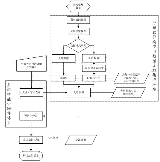
[0026] Such as figure 1 As shown, the method steps of an embodiment of the present invention are as follows:

[0027] 1) Spatial information data with a huge amount of input data, coming from several data sources and distributed in different places;

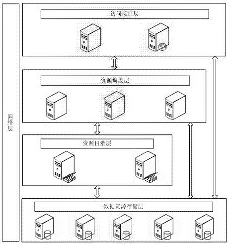
[0028] 2) Build a global resource directory (such as figure 2 ), forming a global virtual view of resources in a distributed computing environment. The global virtual view includes data resource storage layer, resource directory layer, resource scheduling layer, and access interface layer from bottom to top. Each layer communicates in pairs; global resources The directory realizes the discovery, organization and management of massive data in a distributed network environment, and at the same time realizes the unified access and location query of spatial information resources in the distributed database through the data resource access interface;

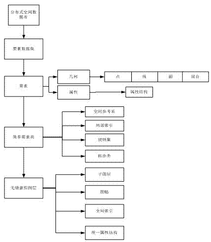
[0029]3) Determine the spatial information data format, if it is raster data, di...


PUM


Abstract

The invention discloses a mass multisource heterogeneous spatial information data seamless integration management method. The method comprises the steps of: building a distributed seamless integration conceptual model, and under the distributed heterogeneous spatial data seamless integration environment, using a multi-layer intelligent middleware system to build a cross-platform, exchangeable, safe and reliable spatial data management system which supports a heterogeneous database, the distributed computation and the cooperative services. According to the method provided by the invention, normalized sharing and low-level integration of the geographic information resource are realized, the data utilization rate is increased, and further the information timeliness and the working efficiency are improved.

Description

technical field [0001] The invention relates to the technical field of spatial data management in geographic information, in particular to a seamlessly integrated and lossless management method for massive multi-source heterogeneous spatial information data. Background technique [0002] The integration and fusion of multi-source information is a hot issue in the field of geoinformation science. Its significance and necessity are closely related to the characteristics of the geoinformation itself, the characteristics of the collection means, and the characteristics of the information processing platform or system. However, in reality, due to the lack of standard basic data, the multi-semantic, multi-temporal and multi-scale expression of data, and the complexity and diversity of data acquisition methods, the generation of multi-source heterogeneous spatial data has resulted. The mass data in the format, on the other hand, people's demand for data cannot be met. Some related...

Claims


Application Information

Patent Timeline
IPC IPC(8): G06F17/30
Inventor 王兆南张蕴灵刘晓东刘玲
Owner ZHEJIANG UNIV
Why Eureka
Try Eureka