

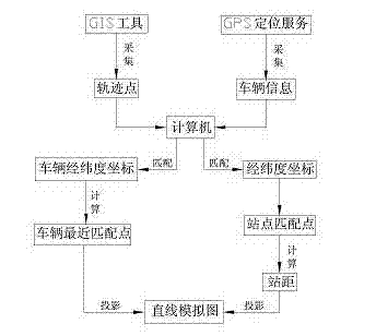
Method for drawing display of bus on straight line simulated diagram by applying tracing points
A trajectory point and simulation map technology, applied in the field of public transport route scheduling, can solve problems such as incoherence, inability to intuitively reflect vehicle distance information, and inconsistency in vehicle location updates.
- Summary
- Abstract
- Description
- Claims
- Application Information
AI Technical Summary
Problems solved by technology
Method used
Image

Examples
Embodiment 1
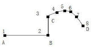
[0090] Such as figure 2 The latitude and longitude coordinates of stations A, B, C, and D of the bus line shown are as follows: (unit °)
[0091] A (32.0000, 126.0000), B (32.0000, 126.0100), C (32.0080, 126.0100), D (32.0070, 126.0185).
[0092] The latitude and longitude coordinates of the track points 1-8 of the bus lines actually collected are:
[0093] 1(32.0000, 126.0000), 2(32.0000, 126.0100), 3(32.0080, 126.0100), 4(32.0090, 126.0143), 5(32.0100, 126.0155), 6(32.0091, 126.80706), 7(32.0091, 126.80706), 7(32.0160) (32.0070, 126.0185).
[0094] (1) According to the longitude and latitude coordinates between two points and the radius of the earth R= 6371 kilometers, first calculate the formula of the shortest distance between two points on a sphere with radius R, arc C=R*arccos[sin(w1)sin(w2) +cos(w1)cos(w2)*cos(j1-j2)] to calculate the shortest distance between two points, and then according to the distance formula D=R*Arccos(C)*π / 180 to calculate every two original ...
Embodiment 2
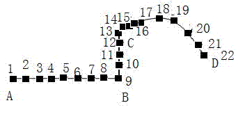
[0138] Such as Figure 6 The latitude and longitude coordinates of the stations A, B, C, D, E, and F of the bus line shown are as follows: (unit °)
[0139] A(34.00000, 124.00000), B(34.00200, 124.01350),
[0140] C(34.00860, 124.01900), D(34.00200, 124.02400),
[0141] E(34.00700, 124.01430), F(34.01350, 124.02490);
[0142] The latitude and longitude coordinates of the track points 1-20 of the bus lines actually collected are:
[0143] 1(34.00000, 124.00000), 2(34.00000, 124.01000), 3(34.00010, 124.01200),
[0144] 4(34.00200, 124.01350), 5(34.00850, 124.01360), 6(34.00950, 124.01400),
[0145] 7(34.00860, 124.01900), 8(34.00450, 124.02400), 9(34.00400, 124.024800),
[0146] 10(34.00200, 124.02400), 11(33.99800, 124.02100), 12(33.99700, 124.01950),
[0147] 13 (33.99900, 124.01940), 14 (34.00700, 124.01430), 15 (34.00840, 124.01550),
[0148] 16 (34.00720, 124.01980), 17 (34.00730, 124.01950), 18 (34.00855, 124.02355),
[0149] 19 (34.01800, 124.02450), 20 (34.01350,...
PUM
 Abstract
Description
Claims
Application Information