Method for classifying remote sensing images

A technology of remote sensing image and classification method, applied in the field of remote sensing image processing, can solve the problems of falling into local optimum, large estimation error, complicated classification training process, etc., so as to avoid classification errors and improve the accuracy of ground object classification.

Inactive Publication Date: 2013-02-20
AIR FORCE UNIV PLA
View PDF1 Cites 15 Cited by
  • Summary
  • Abstract
  • Description
  • Claims
  • Application Information

AI Technical Summary

Problems solved by technology

However, the classification training process of this method is complicated, the estimation error is large, and the discriminant function is determined by e

Method used


Image

  • Method for classifying remote sensing images
  • Method for classifying remote sensing images
  • Method for classifying remote sensing images

Examples


Embodiment Construction

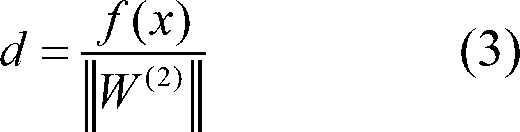
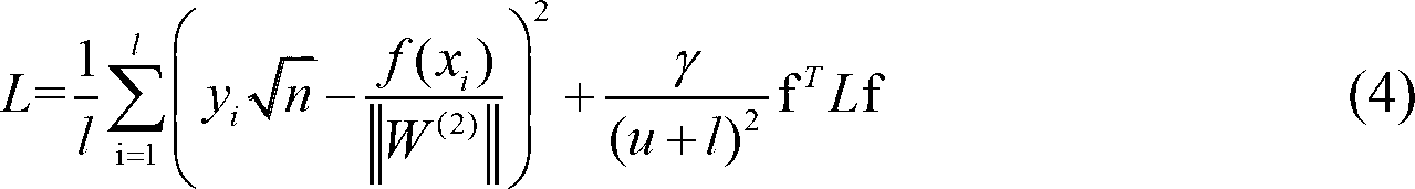
[0009] The technical solution of the present invention comprises the steps of: constructing a semi-supervised neural network model to be used for the object classification of remote sensing images, solving the model with the quasi-Newton method to obtain the object classification result, specifically as follows:

[0010] (1) Build a semi-supervised neural network model

[0011] The gray value of the pixel in the remote sensing image is used as the feature to describe the feature, such as different features (rivers, cultivated land, etc.) have different gray values. From remote sensing images containing multiple ground objects, the features of various ground objects in remote sensing images are extracted. In the present invention, the grayscale features of ground objects are selected, that is, the gray values ​​of all pixels are extracted from remote sensing images to form A collection of samples consisting of pixel grayscale values where sample x 1 ,x 2 ,..., l x, l x 1...


PUM


Abstract

The invention provides a method for classifying remote sensing images, comprising the following steps of: firstly acquiring samples of surface features in a remote sensing image, then constructing a semi-supervised neural network model used for surface feature classification, and finally classifying the surface features based on a semi-supervised neural network. According to the method for classifying the remote sensing images provided by the invention, a structural error is introduced into the semi-supervised neural network for substituting an experience error, so that classification error caused by local minimum locally obtained by a target function is effectively avoided; and a quasi-Newton extreme value solving algorithm used for solving non-linear optimization is introduced in an extreme value solving process, so that surface feature classification accuracy is effectively improved, and beneficial guarantee is provided for applications such as environmental monitoring and topographic mapping which are further carried out subsequently.

Description

technical field [0001] The invention relates to the field of remote sensing image processing, in particular to a method for classifying remote sensing image features. Background technique [0002] Remote sensing images are playing an increasingly important role in various fields of the national economy. Among them, the classification of remote sensing images is particularly important, such as monitoring soil and water loss based on vegetation coverage, calculating and estimating losses based on classified marine oil spill areas, and environmental protection. , The results obtained through remote sensing image classification can automatically generate surveying and mapping maps, etc. In image processing, according to whether the samples used in the classification process are marked or not, the existing remote sensing image classification methods are divided into three types: fully supervised, semi-supervised and unsupervised methods. The document "Semisupervised Neural Netwo...

Claims


Application Information

Patent Timeline
IPC IPC(8): G06K9/62G06N3/02
Inventor 孙莉张群马苗田光见李秀秀马润年
Owner AIR FORCE UNIV PLA
Why Eureka
Try Eureka