Mining subsidence monitoring and early warning method based on multi-source data

A monitoring and early warning, multi-source data technology, applied in data processing applications, forecasting, instruments, etc., can solve the problems of low resolution of monitoring data, GPS receiving antenna blocking, difficulty in meeting the requirements of deformation observation accuracy, etc., to achieve high monitoring accuracy, The effect of improving accuracy

Active Publication Date: 2013-02-20
HUNAN UNIV OF SCI & TECH
View PDF2 Cites 29 Cited by
  • Summary
  • Abstract
  • Description
  • Claims
  • Application Information

AI Technical Summary

Problems solved by technology

The existing level and GPS mine subsidence monitoring methods have the following defects: 1) The method of network deployment observation is labor-intensive and the cost of the monitoring system is high; Requirements; 3) In deep mountains, canyons or areas with dense

Method used


Image

  • Mining subsidence monitoring and early warning method based on multi-source data

Examples


Embodiment Construction

[0015] The present invention will be further described below in conjunction with the accompanying drawings.

[0016] The steps of the present invention are as follows:

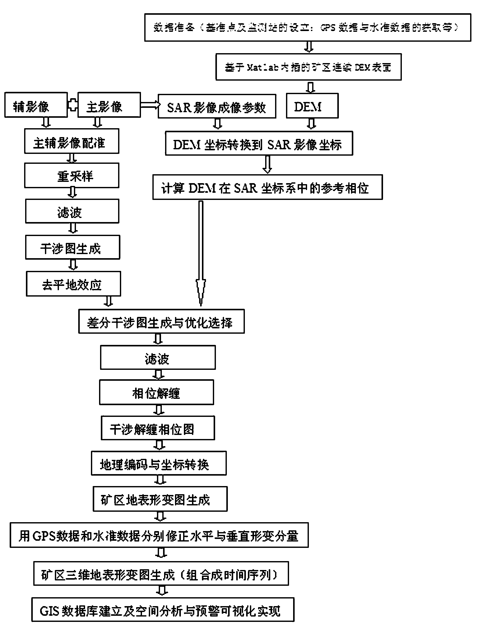
[0017] 1) Acquisition of leveling data and GPS data. Set up stable reference points and deformation monitoring points in the mining area, and conduct regular observations to obtain regular leveling data and GPS data, and measure the topographic map of the mining area.

[0018] 2) Use Matlab software to interpolate the discrete measurement points to generate a smooth DEM surface.

[0019] 3) Acquisition of deformation map of mining area. The SAR image of the mining area and the generated continuous DEM are processed by the two-track method, the appropriate interference data set is selected, the interference image pair is registered, the interference image pair conjugate is multiplied to generate an interferogram, the flat ground effect is removed, and the interference fringe filter is used. Phase unwrapping,...


PUM


Abstract

The invention discloses a mining subsidence monitoring and early warning method based on multi-source data. The mining subsidence monitoring and early warning method comprises the steps of: (1) acquiring standard data and GPS (Global Position System) data; (2) generating mine area DEM by utilizing Matlab software; (3) carrying out dual-rail difference interference process by virtue of DEM and SAR images to obtain a mine area surface deformation result; (4) correcting the mine area surface deformation horizontal and vertical monitoring results respectively according to GPS and standard monitoring data so as to obtain a high-accuracy three-dimensional deformation monitoring chart; (5) establishing an early warning model and a corresponding database; (6) repeating steps (2)-(5) according to the multi-phase measured data and InSAR data until the process is finished; (7) establishing time sequence and buffer analysis models of sinking, horizontal shifting, inclining, curvature deformation and the like of a subsidence area; and (8) determining the influence area according to the time sequence and buffering analysis models and achieving early warning. The mining subsidence monitoring and early warning method integrates standard data, GPS data and SAR data organically, so that the accuracy of the monitoring result is greatly improved.

Description

technical field [0001] The invention relates to a mine subsidence monitoring and early warning method, in particular to a mine subsidence monitoring and early warning method based on multi-source data. Background technique [0002] During the rapid economic development of our country, coal is the main energy source of the national economy. In the process of coal mining, the original stress state of the surface is destroyed, which leads to the redistribution of stress, thus reaching a new equilibrium state. During this process, the rock mass sinks, deforms, and moves, and spreads upward to the surface to form a surface mobile basin, thereby causing damage to surface buildings, railways, water systems, farmland and other production and living facilities, seriously affecting the production of the mining area and the surrounding people. Life. The existing level and GPS mine subsidence monitoring methods have the following defects: 1) The method of network deployment observatio...

Claims


Application Information

Patent Timeline
IPC IPC(8): G06Q10/04G06Q50/02
Inventor 龙四春杨光锐彭强
Owner HUNAN UNIV OF SCI & TECH
Why Eureka
Try Eureka