Radar video image addition method based on electronic chart

A technology of video images and electronic charts, which is applied in the field of navigation and navigation, can solve problems such as hidden dangers of ship navigation safety, and achieve the effect of speeding up the drawing speed and ensuring the safety of navigation.

Active Publication Date: 2013-03-13
TIANJIN NAVIGATION INSTR RES INST
View PDF3 Cites 28 Cited by
  • Summary
  • Abstract
  • Description
  • Claims
  • Application Information

AI Technical Summary

Problems solved by technology

Although positioning, compass, sounding, radar and other equipment are generally installed on existing ships, these equipment work independently and do not make full use of the elec

Method used


Image

  • Radar video image addition method based on electronic chart
  • Radar video image addition method based on electronic chart
  • Radar video image addition method based on electronic chart

Examples


Embodiment Construction

[0026] Embodiments of the present invention will be described in further detail below in conjunction with the accompanying drawings.

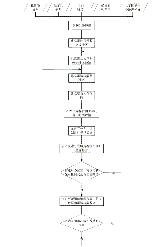
[0027] A radar video image overlay method based on electronic charts, such as figure 1 and figure 2 shown, including the following steps:

[0028] Step 1: Establish a coordinate system using a unified projection method, and establish a radar video buffer according to the projection parameters, which include the projection coordinate system, display scale, pixel size of the display area, rotation angle of the coordinate system, and latitude and longitude of the center of the display area.

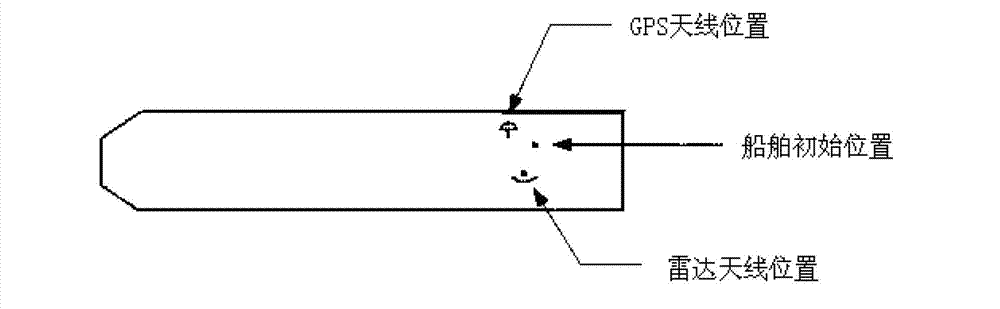
[0029] In this embodiment, the system uses the Mercator projection method to establish a coordinate system, the display area of ​​the electronic chart is 1280*1024 pixels, the current display scale is 1:10000, the display direction of the chart is north upward, and the geographic coordinates of the center of the display area are (38°59.2801'N, 117°42.8741'...


PUM


Abstract

The invention relates to a radar video image addition method based on an electronic chart, which comprises the following steps: establishing a coordinate system by adopting a uniform projective mode, and establishing a radar video buffer area according to protective parameters; 2, acquiring radar center position information, and initializing the radar video buffer area; 3, predetermining the geographical range parameters of the display area of the radar video buffer area; 4, predetermining the video processing parameters of the radar video buffer area; 5, predetermining the color display parameters of the radar video buffer area; 6, filling real-time radar video image data into the radar video buffer area; 7, drawing the data inside the radar video buffer area on electronic chart data; 8, updating the geographic position, course information and radar video image data of a ship in real time, and updating the position information and radar video image display of the ship. The radar video image addition method disclosed by the invention fuses the radar video image data and the electronic chart data and can further ensure the navigation safety of the ship by being adopted as an important collision prevention means in the navigation process of the ship.

Description

technical field [0001] The invention belongs to the field of navigation and navigation, in particular to a method for superimposing radar video images based on electronic charts. Background technique [0002] During the ship's navigation, there are some risk factors that affect the safety of navigation: there are dangerous ships on the sea, stranded dangerous areas, crossing safety contours, crossing restricted areas, crossing dangerous areas, and crossing prohibited navigation areas defined by navigators , close to dangerous object marks, and the height of the ship exceeds the height limit of the object mark, etc. Therefore, how to ensure the safety of the ship's navigation is an urgent problem that needs to be solved at present. Although positioning, compass, sounding, radar and other equipment are generally installed on existing ships, these equipment work independently and do not make full use of the electronic navigation chart (ENC) and radar video image information, an...

Claims


Application Information

Patent Timeline
IPC IPC(8): G01C21/00G01C21/20
Inventor 张晶晶赵燕窦玉宝周璐韩冷赵晶睛
Owner TIANJIN NAVIGATION INSTR RES INST
Why Eureka
Try Eureka