General airplane landing radial line navigation method

A radial line and aircraft technology, applied in navigation, surveying and navigation, road network navigator, etc., can solve hidden dangers, serious safety problems, etc., achieve flexible use, improve safety, and expand the application area.

Inactive Publication Date: 2013-03-20
AVIC NO 631 RES INST
View PDF8 Cites 10 Cited by
  • Summary
  • Abstract
  • Description
  • Claims
  • Application Information

AI Technical Summary

Problems solved by technology

[0005] In order to solve the technical problem that the existing landing navigation method has great potential safety hazards in areas without ground navigation facilities, the present invention provides a general aircraft landing radial navigation method, which is a real-time, intuitive, convenient and reliable The aircraft navigation solution method improves the real-time flight guidance of general aircraft and the realization of the pilot's autonomous operation display, and provides an intuitive and accurate landing navigation method

Method used


Image

  • General airplane landing radial line navigation method
  • General airplane landing radial line navigation method

Examples


Embodiment 1

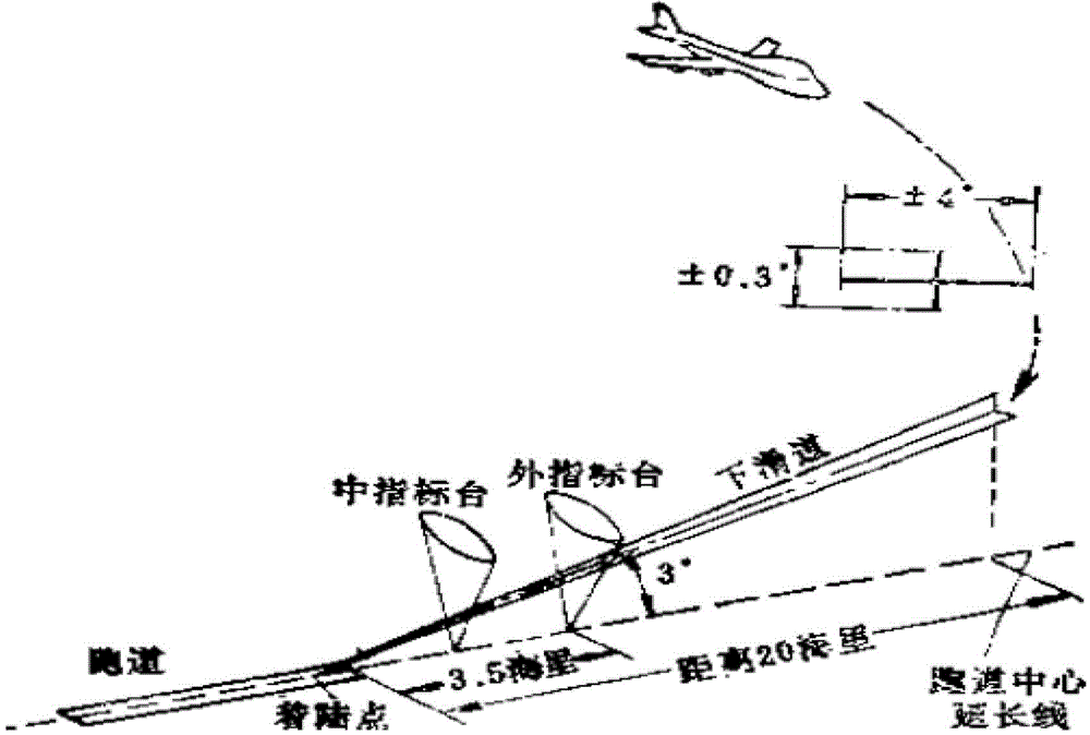
[0027] Embodiment 1: Based on the navigation information of the ground navigation station, a landing radial navigation indication is constructed.

[0028] Under the guidance of the ground navigation station, the aircraft can use the instrument landing method and the radio compass navigation method to approach and land. According to the navigation information of the ground navigation station, the landing radial line navigation method is established. Display the radial line of the runway and the flight direction. The pilot can fly along the set course according to the navigation information of the ground navigation station, such as radio compass, instrument landing and other navigation information. With the support of various ground navigation stations, The runway radial navigation indication technology can be used as an auxiliary navigation method to provide pilots with clear and intuitive landing instructions.

Embodiment 2

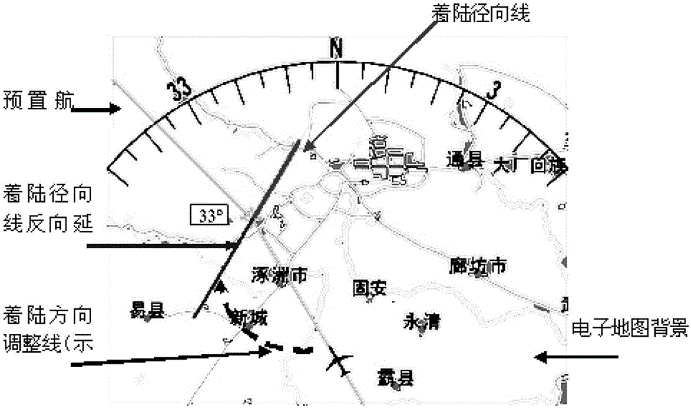
[0029] Embodiment 2: There is no ground navigation station, and geographic information is used to construct the navigation indication of the landing radial line.

[0030] General-purpose aircraft are flexible to use, and the flight area is changeable. When landing without the support of ground navigation stations, it is necessary to use ground geographic information as a benchmark to construct aircraft radial navigation instructions: under the pilot's own control, set in the auxiliary navigation screen The deflection angle of the pre-landing runway or the centerline of the landing area relative to the magnetic North Pole, establishes the landing radial line and its reverse extension line, guides the aircraft to adjust its course in time, and lands accurately and safely along the preset landing direction. In the case of a navigation station, it is an important way to aid navigation and landing.


PUM


Abstract

The invention relates to a general airplane landing radial line navigation method. The general airplane landing radial line navigation method comprises the following steps of 1, building a landing radial line by airborne navigation equipment according to airplane real-time position information provided by an airplane instrument, navigation information provided by a ground navigation station, and a received landing radial line building instruction, carrying out calculation, and displaying the landing radial line and a reverse-direction extending line of the landing radial line by cockpit display equipment, and 2, carrying out landing according to the landing radial line and the navigation information provided by the ground navigation station, guiding an airplane to the reverse-direction extending line of the landing radial line, and adjusting the airplane to make it fly or land along a direction of the landing radial line. The general airplane landing radial line navigation method solves the problem that the existing landing navigation method has a large potential safety hazard in a zone without ground navigation facilities. The general airplane landing radial line navigation method is a real-time, visual, convenient and reliable airplane navigation calculation method, improves an implementation method of real-time flight guidance of a general airplane and pilot autonomous operation display, and provides a visual and accurate landing navigation method.

Description

technical field [0001] The invention relates to a general aircraft landing radial line navigation method. technical background [0002] At present, there are single navigation methods or combined navigation methods commonly used in general-purpose aircraft landing navigation, such as automatic directional navigation and instrument landing navigation. They all use fixed navigation stations on the ground to send navigation and landing information to guide the aircraft to approach and land. The display terminal in the aircraft cockpit uses a fixed and standardized display method for navigation display. A typical schematic diagram of using the ground navigation station information to guide the aircraft to approach and land is as follows: figure 1 shown. [0003] However, general-purpose aircraft are used in a wide range of areas and in flexible ways. Although the aircraft is equipped with navigation equipment such as instrument landing equipment or radio compass, it does not ha...

Claims


Application Information

Patent Timeline
Patent Type & Authority Applications(China)
IPC IPC(8): G01C21/00G01C21/34
Inventor 孔翔李文军缪炜涛赵腊才朱恩亮
Owner AVIC NO 631 RES INST
Why Eureka
Try Eureka