Multisource remote sensing image characteristic combined wharf and ship partition method

A remote sensing image and dock technology, applied in image analysis, image data processing, instruments, etc., can solve problems such as lack of technical models, low resolution of multispectral images, excessive parameter dependence, etc., to expand the scope of application and improve computing efficiency , the effect of improving the universality

Inactive Publication Date: 2013-04-03
NORTH CHINA UNIVERSITY OF TECHNOLOGY +1
View PDF2 Cites 29 Cited by
  • Summary
  • Abstract
  • Description
  • Claims
  • Application Information

AI Technical Summary

Problems solved by technology

[0004] In recent years, scholars at home and abroad have proposed segmentation methods for docks and ships for different situations, mainly for a certain type of remote sensing images, and only use the characteristics of a single image source to segment docks and ships, and cannot comprehensively utilize multiple features of multi-source remote sensing images. Information, resulting in low accuracy of image segmentation, specifically as follows:
[0005] 1. If only multispectral images are used to segment docks and ships, due to the low resolution of multispectral images, false detections often occur when extracting docks and ships;
[0006] 2. If only SAR images are used for the segmentation of docks and ships, there are often fractures at the edges of docks and ships in SAR images. At the same time, there are a lot of noise in SAR images, which has a great impact on target segmentation and may easily cause false detections;
[0007] 3. If only full-color images are used to segment docks and ships, the gray levels of land are rich, and it is difficult to extract land and water areas. It is too computationally intensive to extract docks and ships without determining the location of land and water
[0012] 1. The existing dock and ship segmentation methods only target a single image source, and the accuracy of image segmentation is not high;
[0013] 2. The existing terminal and ship segmentation methods are basically designed and implemented for a specific type of target, lacking an overall technical model as a guide, and being too closely related to specific tasks, resulting in technology decentralization and excessive parameter dependence And the singleness of the processing target makes the universality of the ship and wharf segmentation method very poor;
[0014] 3. The existing dock and ship segmentation method is too complex to result in low efficiency and cannot meet the time requirements

Method used


Image

  • Multisource remote sensing image characteristic combined wharf and ship partition method
  • Multisource remote sensing image characteristic combined wharf and ship partition method
  • Multisource remote sensing image characteristic combined wharf and ship partition method

Examples


Embodiment Construction

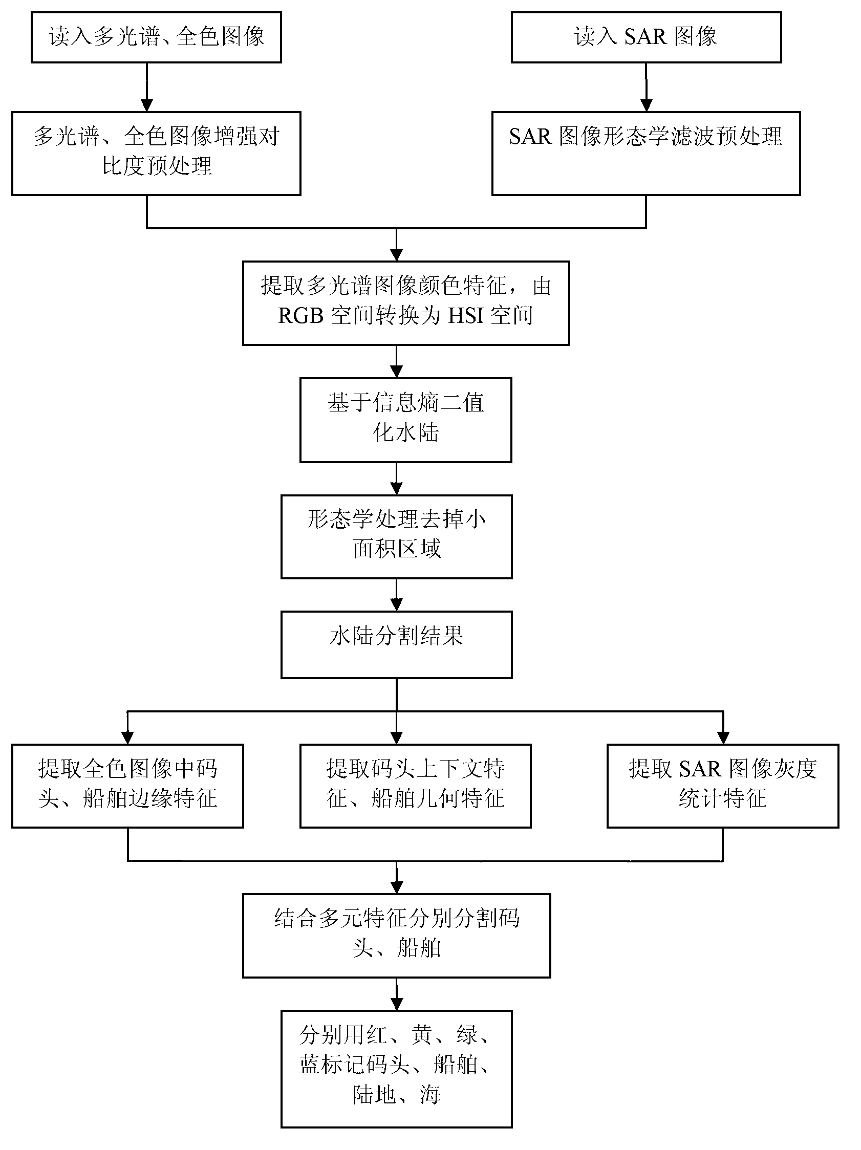
[0055] The invention fully utilizes the multiple features of multi-source images to segment wharves and ships, utilizes the complementarity of different types of remote sensing images to obtain more target information, and improves the accuracy of segmenting wharves and ships.

[0056] Attached below Figure 1~7 The implementation steps of the present invention are further described in detail.

[0057] Step 1: Read in the multispectral, panchromatic and SAR images of docks and ships in the same area.

[0058] Step 2: Preprocess the multispectral, panchromatic and SAR images respectively. Perform preprocessing such as contrast enhancement on multispectral and panchromatic images, and perform morphological filtering preprocessing on SAR images.

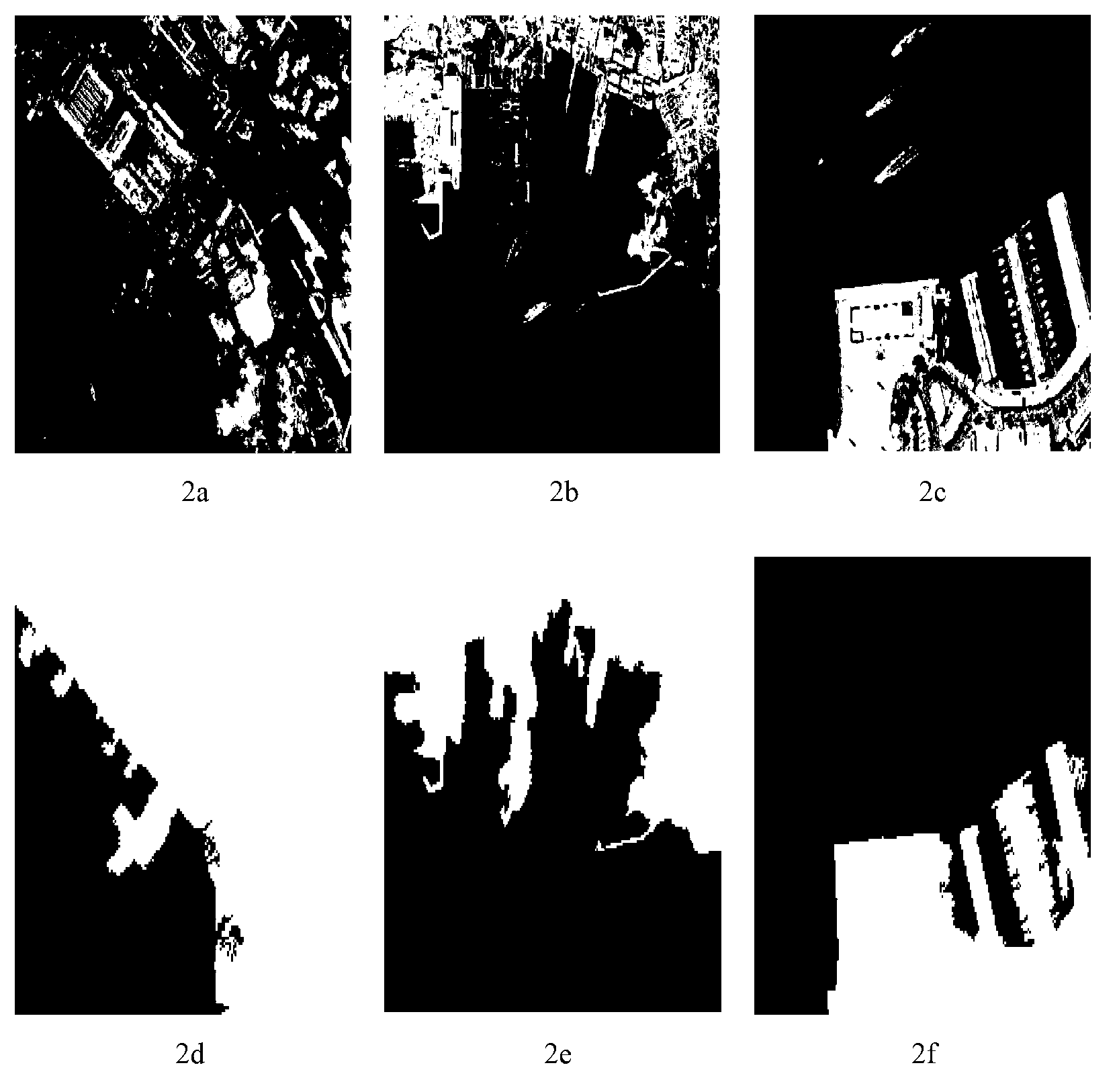
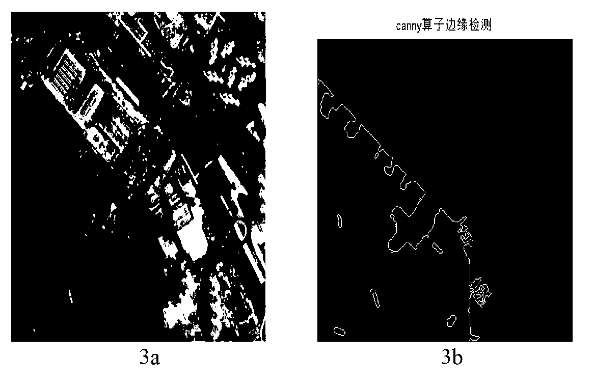
[0059] Piers and ships have obvious color features in multi-spectral images, which are obviously different from the tonal features of water areas. It is easy to identify targets in the images, especially the color difference between w...


PUM


Abstract

The invention discloses a multisource remote sensing image characteristic combined wharf and ship partition method. The method includes the steps: reading a multispectral image, a full-color image and an SAR (synthetic aperture radar) image; preprocessing the three images; converting the multispectral image from an RGB (red, green and blue) space into an HIS (hue, saturation and intensity) space, and subjecting land and water to binarization based on information entropy; morphologically processing to remove a small area to obtain a water and land partition result, wherein the white portion is the land, and the black portion is the water area; for the full-color image, extracting edge features of the wharf and the ship, and extracting context features of the wharf and geometric features of the ship; for the SAR image, extracting gray level statistical characteristics of the wharf and the ship; partitioning the wharf and the ship according to the multi-element characteristics extracted from the SAR image; and subjecting the final partitioned image to color marking. The wharf and the ship are partitioned by making full use of the multi-element characteristics of the multi-source images, more target information is obtained by the aid of complementarity of the different types of remote sensing images, and consequently, accuracy in partition of the wharf and the ship is improved.

Description

technical field [0001] The invention relates to an image segmentation technology, in particular to a wharf and ship segmentation method combined with multi-source remote sensing image features. Background technique [0002] With the development of various remote sensing technologies, more and more countries use remote sensing images for earth observation and monitoring. One of the very important applications is the monitoring and identification of docks and ships. my country has more than 3 million square kilometers of ocean land, with numerous docks and complex shapes. High-efficiency detection methods are needed for dock traffic supervision, marine ship monitoring, fishery management, and search and rescue of ships in distress. Therefore, the development of satellite remote sensing image docks and ship segmentation technology The research has important practical significance, and has broad application prospects both in civilian and military fields. [0003] Image segmentat...

Claims


Application Information

Patent Timeline
Patent Type & Authority Applications(China)
IPC IPC(8): G06T7/00
Inventor 马健喆张永梅周易张睿
Owner NORTH CHINA UNIVERSITY OF TECHNOLOGY
Why Eureka
Try Eureka