A real-time large-scale terrain visualization method based on kd tree
A technology of large-scale terrain and implementation methods, applied in 3D modeling, image data processing, instruments, etc., can solve problems such as unsatisfactory efficiency and high complexity, and achieve the effect of improving visualization speed, realizing simplicity, and reducing use
- Summary
- Abstract
- Description
- Claims
- Application Information
AI Technical Summary
Problems solved by technology
Method used
Image
Examples
Embodiment
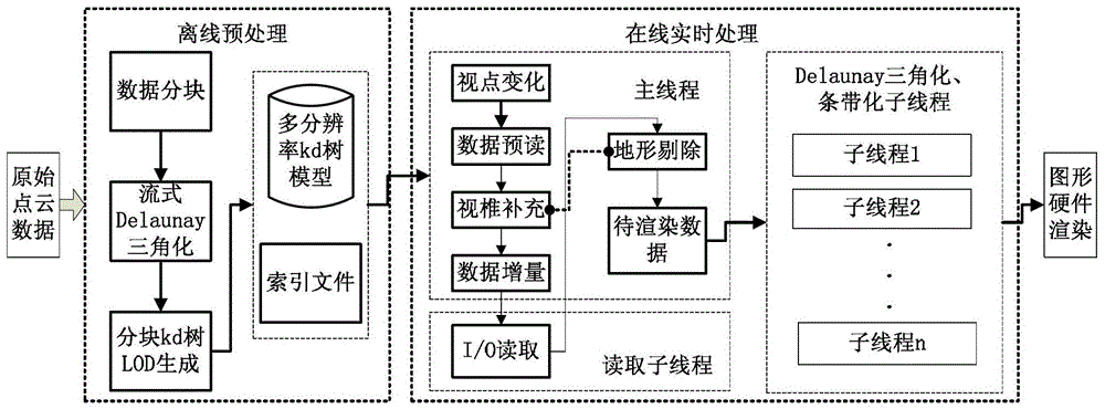
[0057] Such as figure 1 As shown, the kd tree-based real-time large-scale terrain visualization implementation method provided in this embodiment includes the following steps: including the following steps:
[0058] The landform is divided into blocks according to the point cloud space, and the kd tree is used for layering, and the LOD model is established offline. The establishment of the LOD model is responsible for obtaining multi-resolution model data from the terrain point cloud data and switching between the resolutions of the model;
[0059] When online, the LOD model data constructed offline is loaded into the memory by using an external storage algorithm, and the external storage algorithm is responsible for scheduling the LOD model data of the external memory to the memory;
[0060] Using a simplified terrain removal technology for the LOD model data in the memory, the terrain data removal technology is responsible for removing invisible LOD model data, reducing the ...
PUM
 Abstract
Description
Claims
Application Information
 - R&D
- Intellectual Property
- Life Sciences
- Materials
- Tech Scout
- Unparalleled Data Quality
- Higher Quality Content
- 60% Fewer Hallucinations
Browse by: Latest US Patents, China's latest patents, Technical Efficacy Thesaurus, Application Domain, Technology Topic, Popular Technical Reports.
© 2025 PatSnap. All rights reserved.Legal|Privacy policy|Modern Slavery Act Transparency Statement|Sitemap|About US| Contact US: help@patsnap.com


