Shallow sea sand wave area multi-beam sounding terrain reconstruction method based on remote sensing image features

A remote-sensing image and multi-beam technology, which is applied in surveying devices, surveying and navigation, open-air water source survey, etc., can solve problems such as discontinuity of striped multi-beam bathymetric data, inability to construct shallow sea terrain, etc.

Active Publication Date: 2013-06-12
SECOND INST OF OCEANOGRAPHY MNR
View PDF8 Cites 25 Cited by
  • Summary
  • Abstract
  • Description
  • Claims
  • Application Information

AI Technical Summary

Problems solved by technology

However, due to the discontinuity of the striped multi-beam bathymetric data, the continuous shallow sea terrain cannot be constructed only by the above spatial interpolation method

Method used


Image

  • Shallow sea sand wave area multi-beam sounding terrain reconstruction method based on remote sensing image features
  • Shallow sea sand wave area multi-beam sounding terrain reconstruction method based on remote sensing image features
  • Shallow sea sand wave area multi-beam sounding terrain reconstruction method based on remote sensing image features

Examples


Embodiment Construction

[0038]

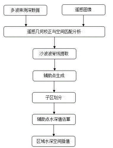
[0039] According to the shallow sea sand wave area multi-beam bathymetric terrain reconstruction method based on remote sensing image features of the present invention, experiments are carried out, such as figure 1 As shown, it specifically includes the following steps:

[0040] 1) Obtain the remote sensing image of the area covered by the multi-beam bathymetric data, and use the geometric correction method for positioning and registration of the remote sensing image to achieve basic spatial registration with the multi-beam bathymetric data:

[0041]Select remote sensing images with higher resolution in the study area to check the clarity and integrity of the sand wave texture information in the images. The spatial registration between the remote sensing image and the multibeam bathymetric data is carried out before the sand wave ridge information is extracted. Image registration adopts the method of ground control points with the same name, that is, select a certai...


PUM


Abstract

The invention provides a novel shallow sea sand wave area multi-beam sounding terrain reconstruction method based on remote sensing image features. Terrain reconstruction is conducted to multi-beam sounding data which are obtained in an interval type measuring line mode by that feature information (sand wave ripples and wave crests) and a sand wave terrain distribution law are utilized, wherein the feature information (sand wave ripples and wave crests) and the sand wave terrain distribution law of the shallow sea sand wave terrain are presented in a remote sensing image. Therefore, integrated sand wave terrain information is obtained. The shallow sea sand wave area multi-beam sounding terrain reconstruction method based on the remote sensing image features aims at terrain mapping requirements of wide distributed shallow sea sand wave terrain areas. Sand wave textures and sand wave crest lines in the remote sensing image are served as reference control information to lead into the multi-beam sounding data terrain reconstruction. High-accuracy shallow sea sand wave area terrain can be reconstructed through the multi-beam sounding data, wherein the multi-beam sounding data are obtained in an interval type measuring line mode. The shallow sea sand wave area multi-beam sounding terrain reconstruction method based on the remote sensing image features is an innovation of a cross application aspect of remote sensing information technology and multi-beam sounding technology. The shallow sea sand wave area multi-beam sounding terrain reconstruction method based on the remote sensing image features has great practical values.

Description

technical field [0001] The invention belongs to the field of remote sensing technology application and seabed topography surveying and mapping, and specifically relates to a multi-beam bathymetry in a shallow sea sand wave area obtained by interval surveying lines by using the characteristic information of sand waves and sand ridges in remote sensing images. methods for efficient terrain reconstruction from data. Background technique [0002] Seabed topographic mapping is the first step in exploring and studying the ocean, the first condition for developing and protecting the ocean, and an urgent need for oceanographic research today. Before the invention of the echo sounder, the water depth was mainly measured by the sounding rod and the sounding hammer, and the measurement accuracy was poor. After the echo sounder appeared in the 1920s, the drawing of sea charts in the modern sense was realized. However, the early echo sounders were launched with a single beam, and one l...

Claims


Application Information

Patent Timeline
Patent Type & Authority Applications(China)
IPC IPC(8): G01C13/00
Inventor 张华国傅斌何谢锴史爱琴王隽王小珍厉冬玲
Owner SECOND INST OF OCEANOGRAPHY MNR
Why Eureka
Try Eureka