Visual intelligent transportation meteorological monitoring and forewarning management system based on Web geographic information system (GIS)

A meteorological monitoring and management system technology, applied to the arrangement of variable traffic instructions, transmission systems, electrical components, etc., can solve the problems of immature and rarely used urban intelligent traffic management systems, etc.

Inactive Publication Date: 2013-06-12
ANHUI DAER INTELLIGENT CONTROL SYST
View PDF5 Cites 21 Cited by
  • Summary
  • Abstract
  • Description
  • Claims
  • Application Information

AI Technical Summary

Problems solved by technology

[0004] At present, the intelligent transportation system has developed rapidly in China, and the weather monitoring system technology is quite mature, but it is rarely used in the urban intelligent traffic management system except for the application on the expressway. At the domestic technical level, it is only in the initial stage of development, and it is not yet mature enough. The visualized intelligent traffic weather monitoring and early warning management system based on WebGIS is only in the research stage.

Method used


Image

  • Visual intelligent transportation meteorological monitoring and forewarning management system based on Web geographic information system (GIS)
  • Visual intelligent transportation meteorological monitoring and forewarning management system based on Web geographic information system (GIS)
  • Visual intelligent transportation meteorological monitoring and forewarning management system based on Web geographic information system (GIS)

Examples


Embodiment Construction

[0023] In order to make the technical means, creative features, goals and effects achieved by the present invention easy to understand, the present invention will be further described below in conjunction with specific illustrations.

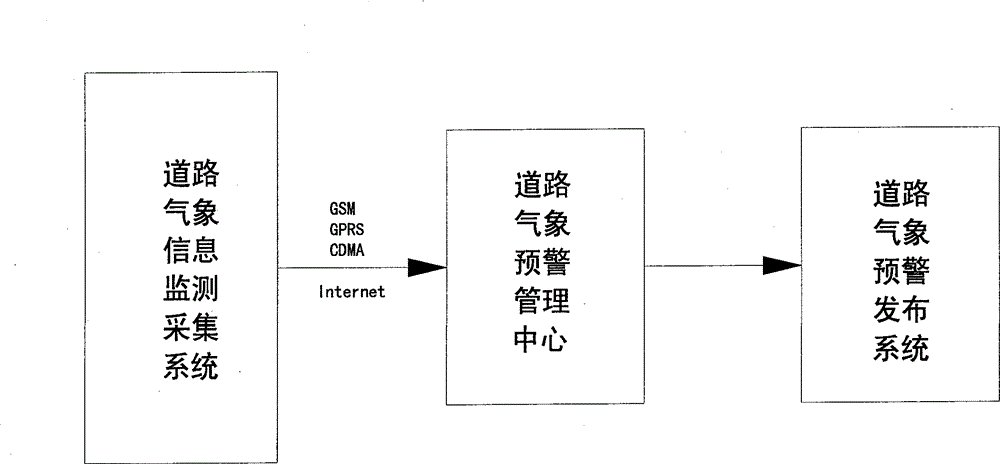
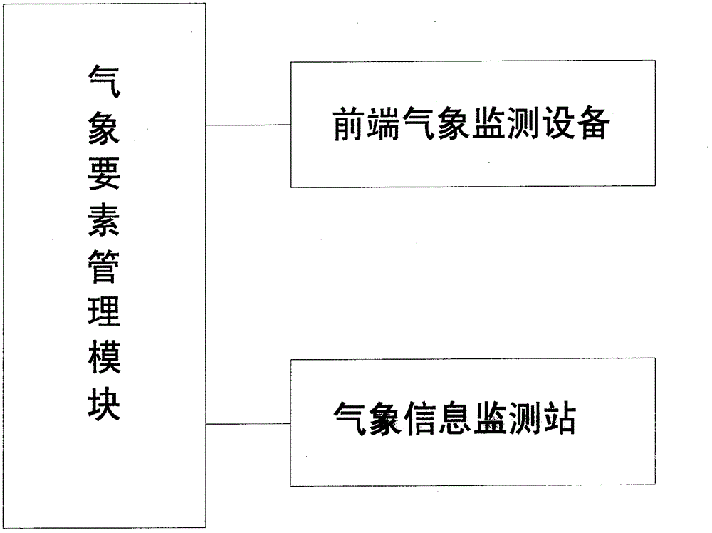
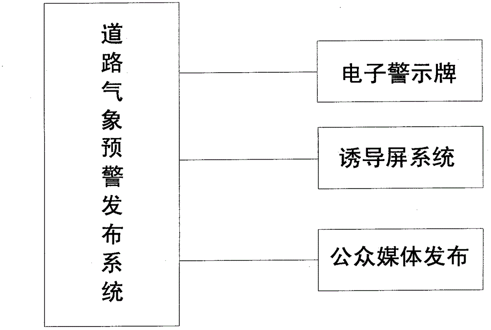
[0024] Such as Figure 1 to Figure 4 As shown, a visualized intelligent traffic weather monitoring and early warning management system based on WebGIS, the system is composed of three parts: road weather information monitoring and collection system, road weather warning release system and road weather warning and management center. Road weather warning and management center Through GSM / GPRS / CDMA or the Internet, it communicates with the road weather information monitoring and collection system and the road weather warning release system. The road weather information monitoring and collection system monitors weather and road condition information in real time, and transmits the monitored information through wired or wireless communication networks...


PUM


Abstract

The invention discloses a visual intelligent traffic meteorological monitoring and forewarning management system based on a Web geographic information system (GIS) and relates to the technical field of meteorological monitoring. The visual intelligent traffic meteorological monitoring and forewarning management system based on the Web GIS is composed of three parts of a road meteorological information monitoring and collection system, a road meteorological forewarning publishing system and a road meteorological forewarning and management center, wherein the road meteorological forewarning and management center is connected with the road meteorological information monitoring and collection system and the road meteorological forewarning publishing system in a communicating mode through a global system for mobile communications (GSM) / a general packet radio service (GPRS) / code division multiple access (CDMA) or Internet. The road meteorological information monitoring and collection system is used for monitoring weather or road condition information in real time and enabling monitored information to be transmitted to the road meteorological forewarning and management center through a wired or wireless communication network, and the road meteorological forewarning and management center is used for carrying out data analysis and management and publishing through the road meteorological forewarning publishing system to guide traffic. The visual intelligent traffic meteorological monitoring and forewarning management system based on the Web GIS is capable of supporting various wired and wireless network communication modes, and a command center server is capable of carrying out remote centralized management and monitoring on a plurality of road traffic meteorological monitoring stations distributed within a wide range through networks.

Description

technical field [0001] The invention relates to the technical field of meteorological monitoring, in particular to a WebGIS-based visualized intelligent traffic meteorological monitoring and early warning management system. Background technique [0002] In July this year, heavy rain fell in Beijing, flooding, landslides and other dangers occurred on many urban roads. Because the relevant departments failed to provide real-time road traffic weather information in time, many vehicles were flooded and many drivers and passengers died. In recent years, the occurrence of similar incidents across the country shows that the impact of meteorological conditions on road traffic has become increasingly obvious, and it is particularly important to strengthen road traffic meteorological monitoring and early warning to ensure road traffic safety. [0003] At present, geographic information system (GIS) is widely used in road survey, traffic control and construction planning and other fiel...

Claims


Application Information

Patent Timeline
Patent Type & Authority Applications(China)
IPC IPC(8): G08G1/09H04L29/08
Inventor 杨潘
Owner ANHUI DAER INTELLIGENT CONTROL SYST
Why Eureka
Try Eureka