A GNSS global and regional ionospheric delay seamless fusion expression and correction method

An ionospheric delay and seamless fusion technology, applied in the field of global navigation systems, can solve problems such as loss of model accuracy, discontinuity, and difficulty in seamless fusion of ionospheric grid map models

Active Publication Date: 2014-10-22
WUHAN UNIV
View PDF3 Cites 0 Cited by
  • Summary
  • Abstract
  • Description
  • Claims
  • Application Information

AI Technical Summary

Problems solved by technology

[0002] The network of navigation satellite observation stations provides an effective means for ionospheric monitoring. The traditional ionospheric delay models established by navigation satellite systems are expressed in the form of regular grids, such as the I file provided by the International Navigation Satellite Service (IGS) The ionospheric model is provided in the form of regular grid points, and users use the delay values ​​on the regular grid provided by the I file to interpolate the ionospheric delay at their own puncture points. This method is characterized by a simple data structure and easy management. It is convenient to make a three-dimensional map for research and analysis; its disadvantage is that this expression method needs to first project the ionospheric delay of the oblique path to the zenith direction, and then interpolate it to the regular grid points, and both projection and interpolation will lose Model accuracy; on the other hand, the layout of observation stations and the satellite graphic structure determine that the distribution of puncture points cannot be uniform. However, since the grid size in the entire ionospheric modeling range is fixed, the loss of puncture points will be dense if the grid is too large. If the grid is too small, there will be a large amount of redundant data in the sparse area of ​​the puncture point; finally, it is difficult to achieve seamless fusion of the ionospheric grid map model established by using different reference station networks. The ionospheric delay value obtained by the interpolation of the ionospheric grid map actually has a certain discontinuity
[0003] To sum up, the currently widely used regular grid description method is not suitable for high-precision ionospheric delay expression, nor is it suitable for continuous and seamless service of ionospheric correction across regions; however, navigation user positioning accuracy and its convergence speed It largely depends on the effect of ionospheric delay correction. Therefore, with the promotion of satellite navigation technology, constructing a more appropriate ionospheric delay expression method is an important means to improve its correction accuracy

Method used


Image

  • A GNSS global and regional ionospheric delay seamless fusion expression and correction method
  • A GNSS global and regional ionospheric delay seamless fusion expression and correction method
  • A GNSS global and regional ionospheric delay seamless fusion expression and correction method

Examples


Embodiment Construction

[0030] The present invention will be further described below in conjunction with the accompanying drawings.

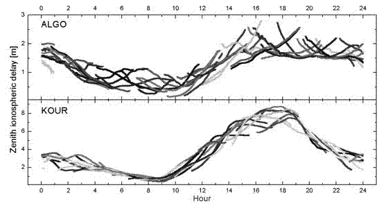
[0031] Such as Figure 9 As shown, a GNSS global and regional ionospheric delay seamless fusion expression and correction method includes the following steps,

[0032] Step 1. Extract the ionospheric delay of each oblique path on the server side; extracting the high-precision ionospheric delay value of the oblique path is the basis for expressing and correcting the ionospheric delay;

[0033] The realization method is as follows: use the dual-frequency original observation values ​​of the reference station (observation data of the reference station) to establish the observation equation, rationally parameterize the ionosphere, establish a single-station ionosphere model, obtain the ionosphere function, and combine the parameters of the ionosphere function and the position parameters Simultaneously solve to obtain the ionospheric delay of each oblique path, such as fi...


PUM


Abstract

The invention provides a seamless fusion expression and correction method of global navigation satellite system (GNSS) global and regional ionospheric delay. Ionospheric delay above regions are expressed as a series of satellite-observation station pair elementary units, and new ionospheric delay quantities provided by newly added observation stations or satellites are used as independent units and directly added to the tail of a sequence so that seamless fusion expression of the ionospheric delay in any range is achieved; the inside of a single observation station-satellite pair unit is expressed as a satellite number plus a puncture point azimuth angle plus a puncture point elevating angle plus slant path ionospheric delay plus slant path ionospheric delay accuracy, and users select a plurality of the most matchable slant path ionospheric delay pairs interpolated by ionospheric delay correction quantity of the users according to the satellite number, the puncture point azimuth angle and the puncture point elevating angle after receiving sequences of slant path ionospheric delay pairs. The seamless fusion expression and correction method retains ionospheric delay expression and correction accuracy in an uttermost mode and achieves seamless fusion of global ionospheric expression and correction models.

Description

technical field [0001] The invention belongs to the field of global navigation systems, in particular to a GNSS global and regional ionospheric delay seamless fusion expression and correction method. Background technique [0002] The network of navigation satellite observation stations provides an effective means for ionospheric monitoring. The traditional ionospheric delay models established by navigation satellite systems are expressed in the form of regular grids, such as the I file provided by the International Navigation Satellite Service (IGS) The ionospheric model is provided in the form of regular grid points, and users use the delay values ​​on the regular grid provided by the I file to interpolate the ionospheric delay at their own puncture points. This method is characterized by a simple data structure and easy management. It is convenient to make a three-dimensional map for research and analysis; its disadvantage is that this expression method needs to first proj...

Claims


Application Information

Patent Timeline
Patent Type & Authority Patents(China)
IPC IPC(8): G01S19/07
Inventor 辜声峰楼益栋张同施闯郑刚
Owner WUHAN UNIV
Why Eureka
Try Eureka