Geology shooting instrument

A technology of photographing instrument and geology, applied in the field of photographing instrument, can solve the problem that geological photos cannot directly obtain relevant geological information, and the photo shooting time, etc., to achieve the effect of expanding the degree of public participation, reducing the carrying amount, and being convenient for preservation.

Inactive Publication Date: 2013-08-07
王德文 +1
View PDF5 Cites 11 Cited by
  • Summary
  • Abstract
  • Description
  • Claims
  • Application Information

AI Technical Summary

Problems solved by technology

[0005] Aiming at the problem that the geological photos obtained by existing cameras cannot directly obtain information such as relevant geological information, coordinates when the camera is taken, and the shooting time of the photos; Geological pictures of

Method used


Image

  • Geology shooting instrument
  • Geology shooting instrument
  • Geology shooting instrument

Examples


Embodiment Construction

[0036] In order to facilitate the understanding of those skilled in the art, the present invention will be further described below with reference to the accompanying drawings and embodiments.

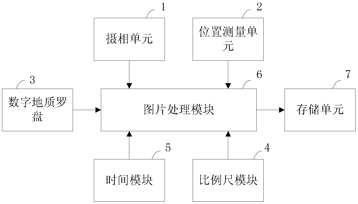
[0037] figure 1 Shown is the first embodiment of the geological camera of the present invention. The geological camera includes:

[0038] The camera unit 1 is used to obtain geological photos of the subject to be photographed; its main structure is the same as that of an ordinary digital camera, including an optical lens, a photoelectric sensor, an A / D converter, a digital signal processor, an image processing unit, etc.;

[0039] The position measurement unit 2 is used to obtain the geographic coordinates of the location where the geological camera is located, and adopts the GPS positioning method;

[0040] The digital geological compass 3 is used to measure the orientation of the subject to be photographed relative to the geological photographing instrument, to measure the occurrenc...


PUM


Abstract

The invention discloses a geology shooting instrument, which comprises a shooting unit, a position measuring unit, a digital geology compass, a scale module, a time module, a picture processing module and a memory cell; the picture processing module combines or superimposes parameters obtained by the position measuring unit, the digital geology compass, the scale module and the time module and geology photographs obtained by the shooting unit for forming a geology picture, and sends the geology pictures to the memory cell. The geology shooting instrument can obtain geology pictures containing related parameters at one time, and real and high accuracy geology information can be obtained by the geology picture, and simultaneously workloads for geology personnel to record field data are minimized, and human errors of data are avoided; moreover, the geology shooting instrument can integrate the functions of compass, camera and field record book, thereby minimizing the carrying amount of field geology apparatuses.

Description

technical field [0001] The invention relates to a geological survey instrument, in particular to a photographing instrument used for collecting geological information and geological photos in geological survey. Background technique [0002] With the development of the national economy and the accelerating process of new urbanization, the technical support and guarantee of geological work for economic construction and urban development has become increasingly prominent, especially the quality requirements of urban geological and environmental geological work are getting higher and higher. Resource geological survey, hydraulic and environmental survey, etc. On the basis of traditional theories and technical standards, the practical application of new theories, new technologies, new processes and new equipment is becoming more and more extensive. [0003] The traditional regional geological survey is to observe the geological phenomenon through continuous field geological rout...

Claims


Application Information

Patent Timeline
Patent Type & Authority Applications(China)
IPC IPC(8): G01C11/00
Inventor 王德荣
Owner 王德文
Why Eureka
Try Eureka