Automatic geometric correction method for wide remote-sensing images

A technology of geometric correction and remote sensing image, applied in the field of remote sensing image correction, can solve the problems of low accuracy of attitude measurement, low frequency of attitude data recording, large coverage, etc. The effect of improving accuracy

Active Publication Date: 2013-10-02
SATELLITE SURVEYING & MAPPING APPL CENTSASMAC NAT ADMINISTATION OF SURVEYING MAPPING & GEOINFORMATION OF CHINANASG
View PDF4 Cites 21 Cited by
  • Summary
  • Abstract
  • Description
  • Claims
  • Application Information

AI Technical Summary

Problems solved by technology

However, the environmental disaster reduction satellite image covers a large area, and it is difficult to accurately express the geometric relationship between the object point and the image point with a suitable polynomial; the attitude data recor

Method used


Image

  • Automatic geometric correction method for wide remote-sensing images
  • Automatic geometric correction method for wide remote-sensing images
  • Automatic geometric correction method for wide remote-sensing images

Examples


Embodiment Construction

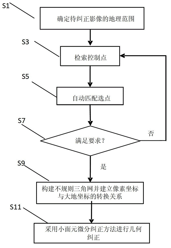
[0033] In order to make the objectives, technical solutions, and advantages of the embodiments of the present invention clearer, the technical solutions of the embodiments of the present invention will be described clearly and completely in conjunction with the accompanying drawings of the embodiments of the present invention. Obviously, the described embodiments are part of the embodiments of the present invention, rather than all of the embodiments. Based on the described embodiments of the present invention, all other embodiments obtained by a person of ordinary skill in the art without creative work shall fall within the protection scope of the present invention.

[0034] Unless otherwise defined, the technical or scientific terms used herein shall have the usual meanings understood by those with ordinary skills in the field to which the present invention belongs. The "first", "second" and similar words used in the specification and claims of the patent application of the pre...


PUM


Abstract

The invention relates to an automatic geometric correction method for wide remote-sensing images based on a control point image database. The automatic geometric correction method comprises the steps of determining the geographical range of an image to be corrected; searching all control points meeting the requirements in the control point image database according to the determined geographical range of the image to be corrected; carrying out automatic matching point selection; determining control points used for geometric correction; judging whether the number and the distribution of the matched control points meet the requirements of geometric correction or not, if so, then entering the next step, and if not, then returning back to the step of searching; constructing a triangular irregular network based on the matched control point pairs and establishing the transformational relation between pixel coordinates and geodetic coordinates; and carrying out geometric correction based on a small surface element differential correction method to obtain a corrected digital orthoimage. The method provided by the invention realizes automatic searching and automatic matching of control point images, thereby being capable of reducing the time spent on collecting and selecting the control points; and the small surface element geometric correction method is adopted, thereby being capable of improving the precision of wide image geometric correction.

Description

Technical field [0001] The present invention relates to a remote sensing image correction method, more specifically to an automatic geometric correction method for wide-range remote sensing images based on a control point image database. Background technique [0002] With the development of remote sensing technology, especially the continuous development of remote sensing sensor technology, the use of remote sensing images or data obtained through remote sensing technology is becoming wider and wider. At present, the application scope of remote sensing data has been extended to the field of social information services, for example, widely used in surveying and mapping, agriculture, forestry, geology and minerals, hydrology and water resources, environmental monitoring, natural disasters, regional analysis and planning, military, land use, etc. aspect. Remote sensing images with precise geocoding can provide the features and information required by different fields such as land, ...

Claims


Application Information

Patent Timeline
IPC IPC(8): G06T5/00G06F17/30
Inventor 王华斌李国元唐新明张本奎王雪锋祝小勇
Owner SATELLITE SURVEYING & MAPPING APPL CENTSASMAC NAT ADMINISTATION OF SURVEYING MAPPING & GEOINFORMATION OF CHINANASG
Why Eureka
Try Eureka