Area enhanced precision positioning service method suitable for large-scale users

A technology of precise positioning and service method, which is applied in the area of ​​enhanced precision positioning service applicable to large-scale users, can solve the problems of limiting the number of users serving at the same time, the burden of large real-time data communication, and accelerating the convergence speed of RTPPP ambiguity, etc., to achieve The effect of increasing the number of precise positioning users and solving the burden of real-time data communication

Inactive Publication Date: 2013-10-09
WUHAN UNIV
View PDF3 Cites 32 Cited by
  • Summary
  • Abstract
  • Description
  • Claims
  • Application Information

AI Technical Summary

Problems solved by technology

The non-difference network RTK method can significantly speed up the RTPPP ambiguity convergence speed, but the user needs to obtain the area enhancement information of the surrounding reference stations in real time, and the validity period of the informatio

Method used


Image

  • Area enhanced precision positioning service method suitable for large-scale users
  • Area enhanced precision positioning service method suitable for large-scale users
  • Area enhanced precision positioning service method suitable for large-scale users

Examples


Embodiment Construction

[0034] The present invention will be further elaborated below in conjunction with the accompanying drawings and specific embodiments.

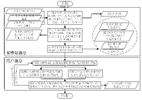
[0035] please see figure 1 , the technical solution adopted in the present invention is: a method for area-enhanced precise positioning service applicable to large-scale users, comprising the following steps:

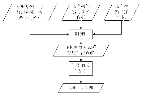
[0036] Step 1: Select more than one reference station, use the real-time observation data of the reference station, real-time precise satellite orbit information, satellite clock error information and the known coordinates of the reference station, and fix the coordinates of the reference station as known true values ​​to perform RTPPP.

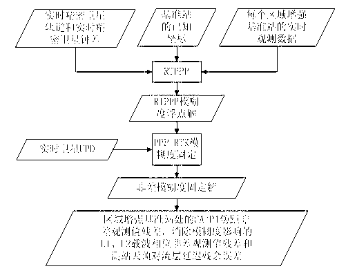
[0037] Step 2: Unify the MW ambiguity floating-point solution of the carrier wide-lane & pseudo-range narrow-lane combination observation value MW floating-point solution of the RTPPP at different reference stations and the dual-frequency ionosphere-free combination observation value IF ambiguity float...


PUM


Abstract

The invention discloses an area enhanced precision positioning service method suitable for large-scale users. According to the technical scheme, the method includes the steps that after the users effectively fix wide-lane ambiguity and L1 ambiguity of at least four satellites in a zero difference network RTK processing mode, area enhanced information of surrounding base stations does not need to be acquired, at this moment ambiguity fixed results and zenith troposphere delay residual errors acquired by interpolation are used as known truth values, received satellite UPD information is combined, and an ambiguity fixed solution in a PP-RTK mode can be immediately acquired without initialization. Due to the fact that satellite UPD, real-time satellite orbits and real-time satellite clock errors are only related to the satellites, and short-term forecast lasting tens of seconds to a few minutes can be conducted, the information can be broadcasted to the users through the communication satellites in a broadcast mode, and then real-time data communication burdens among the users and the base stations can be greatly reduced. Once user ambiguity is firstly fixed, the number of the users simultaneously serviced by an area enhanced system is no longer restricted at this moment.

Description

technical field [0001] The invention belongs to the field of global navigation satellite system (Global Navigation Satellite System, GNSS), and is a method for providing fast, real-time and precise positioning services for large-scale users by using an area augmentation system. Location service method. Background technique [0002] With the rapid development of GNSS, fast real-time precise positioning technology has been more and more widely used in the fields of landslide monitoring, earthquake monitoring, precision agriculture, precise navigation and positioning of vehicles, ships and aircrafts, and the number of its users is growing geometrically. , followed by the problem that the increase in the number of users cannot be met due to the limited data communication capability. How to provide rapid real-time precise positioning services for more different types of users on the basis of the existing regional enhancement system and real-time data communication service capabi...

Claims


Application Information

Patent Timeline
IPC IPC(8): G01S19/44
Inventor 邹璇施闯唐卫明刘经南楼益栋李敏
Owner WUHAN UNIV
Why Eureka
Try Eureka