Self-adaption spatial interpolation method and system based on spatial feature analysis

A spatial interpolation and adaptive technology, applied in special data processing applications, instruments, electrical digital data processing, etc., can solve the problems of slow interpolation, low interpolation accuracy, low interpolation accuracy, etc., to achieve accurate prediction, improve interpolation accuracy, Inexpensive effect

Active Publication Date: 2013-10-16
SUN YAT SEN UNIV
View PDF3 Cites 18 Cited by
  • Summary
  • Abstract
  • Description
  • Claims
  • Application Information

AI Technical Summary

Problems solved by technology

The above two spatial interpolation methods have the following defects: IDW method only considers the distance between two points in space, but does not consider the spatial distribution characteristics, so the interpolation accuracy is usually low; although the Kriging method considers the spatial distribution characteristics, it involves the calculation of solving equations The problem of larg

Method used


Image

  • Self-adaption spatial interpolation method and system based on spatial feature analysis
  • Self-adaption spatial interpolation method and system based on spatial feature analysis
  • Self-adaption spatial interpolation method and system based on spatial feature analysis

Examples


Embodiment Construction

[0048] Embodiments of the present invention will now be described with reference to the drawings, in which like reference numerals represent like elements.

[0049] Please refer to figure 1 , the present invention's adaptive spatial interpolation method based on spatial feature analysis comprises the following steps:

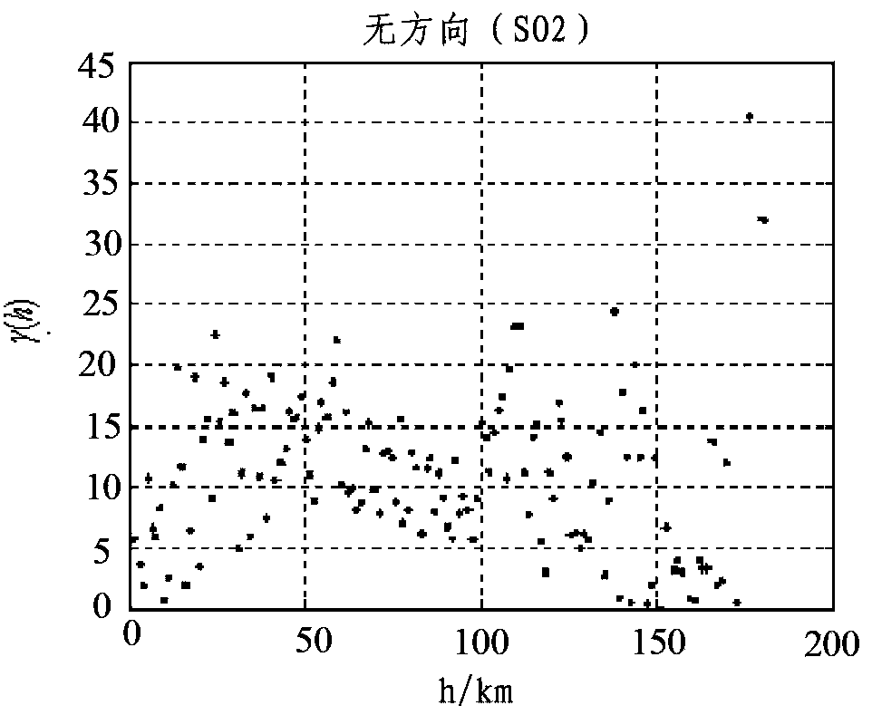
[0050] S1: Based on the automatic monitoring data of the atmospheric environment on a single time slice, extract geographic location information and pollutant monitoring values, where the geographic location information and pollutant monitoring values ​​need to be in one-to-one correspondence; specifically, the Pearl River Delta on August 24, 2012 Region 62 Sites SO 2 Taking the monitoring data as an example, first extract the geographic location information and SO of 62 stations 2 Concentration information, using MATLAB software, using x, y, z coordinates to represent the longitude, latitude and pollutant concentration data of each station, as follows:

[00...


PUM


Abstract

The invention discloses a self-adaption spatial interpolation method based on spatial feature analysis. The method comprises the steps as follows: a pollutant monitoring value is extracted; an interpolation module is established on the basis of a variation function; a direction feature is introduced to the interpolation module and the variation function; the spatial distribution of a pollutant is judged to be isotropic or anisotropic; a search strategy is set based on all the isotropy and all the anisotropy, so that a reference point is determined; and a pollutant concentration attribute value of an interpolating point is determined according to variation function expression formulas in all directions and the reference point. Compared with the prior art, the self-adaption spatial interpolation method is generated after the spatial features of sample point data are analyzed on the premise that the spatial distribution features of the sample point data are considered, the calculation amount is small, and the interpolation is improved, so that a attribute value of an unknown point of a study area is predicted more accurately. The invention discloses a self-adaption spatial interpolation system based on the spatial distribution features.

Description

technical field [0001] The invention relates to the technical field of environmental monitoring, in particular to an adaptive spatial interpolation method based on spatial feature analysis and a system thereof. Background technique [0002] The point layout method stipulated in the current automatic detection specification cannot observe all points in the space. However, based on the monitoring network that has been deployed, a certain number of spatial samples can be obtained. These samples reflect all or part of the characteristics of the spatial distribution. According to these Known samples, using appropriate spatial interpolation methods, can more accurately predict the characteristics of unknown geographic spaces. [0003] Common spatial interpolation methods include Inverse Distance Weighted Interpolation (IDW) and Kriging. The above two spatial interpolation methods have the following defects: IDW method only considers the distance between two points in space, but d...

Claims


Application Information

Patent Timeline
IPC IPC(8): G06F19/00
Inventor 徐伟嘉李红霞郑镇华曾雪兰
Owner SUN YAT SEN UNIV
Why Eureka
Try Eureka