Route planning system and route planning method combining real-time road condition and public traffic operation information

A technology of route planning and real-time road conditions, which is applied in the field of intelligent transportation, can solve the problems of formulating travel planning, not being able to provide bus routes, and not being able to know the time spent on public transportation in a timely manner, and achieve high reliability.

Active Publication Date: 2013-10-23
BEIJING PALMGO INFOTECH CO LTD
View PDF10 Cites 61 Cited by
  • Summary
  • Abstract
  • Description
  • Claims
  • Application Information

AI Technical Summary

Problems solved by technology

The car navigation provided by the current navigation software does not involve the real-time operation time of public transportation, and cannot provide the bus route related to the actual operation situation
This makes it impossible for users to know the operation status of public transport, and cannot keep abreast of the travel time of public transport, and often wastes

Method used


Image

  • Route planning system and route planning method combining real-time road condition and public traffic operation information
  • Route planning system and route planning method combining real-time road condition and public traffic operation information
  • Route planning system and route planning method combining real-time road condition and public traffic operation information

Examples


Embodiment Construction

[0015] In order to make the object, technical solution and advantages of the present invention clearer, the present invention will be further described in detail below in conjunction with the accompanying drawings.

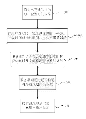
[0016] The embodiment of the present invention adopts the method of combining the operating time of public transport with real-time road conditions to provide users with real-time, predictable, and highly reliable route planning, as well as relatively accurate travel time reference, and users can combine their own needs. To formulate / adjust travel planning based on public transport.

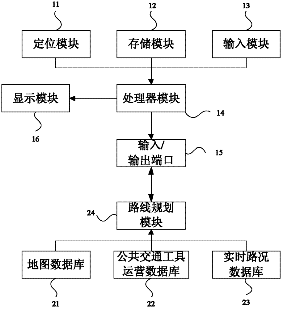
[0017] This embodiment provides a route planning system that combines real-time road conditions and public transport operating information, such as figure 1 As shown, the system includes a client and a server, where,

[0018] On the client side include:

[0019] The positioning module 11 is used to fuse the output information of different sensors to automatically determine the curr...


PUM


Abstract

The invention discloses a route planning system and a route planning method combining real-time road condition and public traffic operation information, relating to the field of intelligent traffic. The method comprises the following steps: determining a departure place and a destination, setting time information, and uploading the departure place, the destination and the time information to a server terminal; and receiving the departure place, the destination and the time information through the server terminal, and planning a route according to the departure place and the destination, and combining the real-time operation information of public traffic and real-time road condition to obtain the time cost of the route planning by utilizing the time information. The system comprises the server terminal and a client. A method of combining the operation time of public traffic with the real-time road condition is adopted for providing real-time, predicable and reliable route plan and relatively accurate travel time reference to a user, so that the user can plan/regulate travel plan based on the public traffic according to demand.

Description

technical field [0001] The invention relates to the field of intelligent transportation, in particular to a route planning system and method combining real-time road conditions and public transportation operation information. Background technique [0002] With the rapid development of computer and positioning technology, global positioning system and map service have been widely valued and applied. The effective combination of map and position positioning technology has a very broad application prospect. In recent years, services such as car navigation, handheld navigation, and network map have been launched one after another. With the development of geographic information technology, positioning technology and mobile communication technology, new map application forms based on mobile terminals have emerged, which are favored by users for their mobility and convenience. [0003] The navigation service in the map service is divided into driving navigation, car navigation, wa...

Claims


Application Information

Patent Timeline
IPC IPC(8): G01C21/34
Inventor 李宏于晓崔磊由武全李美京
Owner BEIJING PALMGO INFOTECH CO LTD
Why Eureka
Try Eureka