Surface collapse microseism three-dimensional positioning and monitoring method and system

A technology of three-dimensional positioning and monitoring system, which is applied in the direction of radio wave measurement system, positioning, signal transmission system, etc., can solve the problem of high implementation cost, achieve three-dimensional accurate positioning, reduce adverse effects, and improve monitoring accuracy and timeliness Effect

Inactive Publication Date: 2013-11-27
CENT FOR HYDROGEOLOGY & ENVIRONMENTAL GEOLOGY CGS
View PDF5 Cites 11 Cited by
  • Summary
  • Abstract
  • Description
  • Claims
  • Application Information

AI Technical Summary

Problems solved by technology

The disadvantage of this method is

Method used


Image

  • Surface collapse microseism three-dimensional positioning and monitoring method and system
  • Surface collapse microseism three-dimensional positioning and monitoring method and system
  • Surface collapse microseism three-dimensional positioning and monitoring method and system

Examples


Embodiment Construction

[0024] In order to further explain the technical means and effects of the present invention to achieve the intended purpose of the invention, the following is combined with the preferred embodiments to describe the specific implementation methods, features and features of the ground subsidence micro-seismic three-dimensional positioning monitoring method and system proposed in the present invention. Efficacy, detailed as follows.

[0025] Combine below Figure 1-5 The system and method of the present invention are described together.

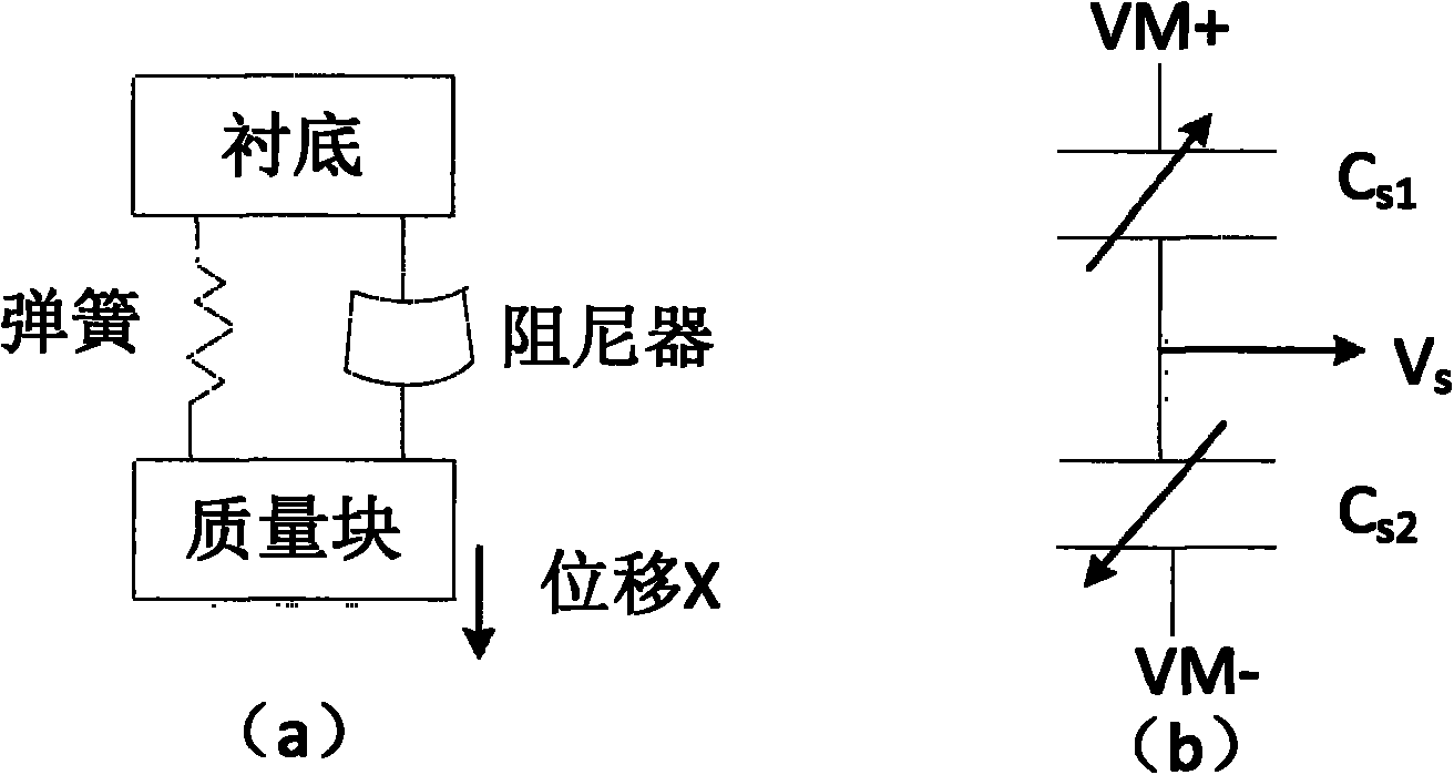
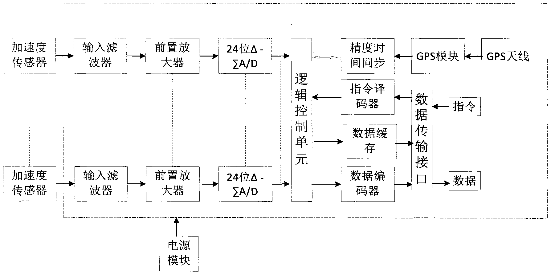
[0026] The ground subsidence microseismic three-dimensional monitoring system of this embodiment mainly includes: a plurality of geophones (also referred to as acoustic wave sensors or shock pickups), at least one (usually multiple) data collection stations and a control center, wherein the geophones There is a wired connection with the data collection station, and a wireless connection between the data collection station and the control center...


PUM


Abstract

The invention relates to a surface collapse microseism three-dimensional positioning and monitoring method and system. The system comprises a plurality of detectors, at least one data collecting station and a control center, wherein the data collecting station is used for converting analog electrical signals collected by the detectors into digital monitoring signals and sending the digital monitoring signals to the control center through a wireless transmission network, the control center is used for receiving the digital monitoring signals transmitted from the data collecting station and conducting the focus inversion operation according to the digital monitoring signals, therefore, the focus can be positioned, and three-dimensional display imaging is achieved. The data collecting station comprises an input filter, a pre-amplifier, an analog-to-digital conversion module, a logic control unit, a data encoder, a wireless data transmission interface and a power module. According to the technical scheme, surface collapse can be easily, conveniently, timely, accurately and inexpensively monitored in real time.

Description

technical field [0001] The invention relates to ground subsidence monitoring technology, in particular to a ground subsidence micro-seismic three-dimensional positioning monitoring method and system. Background technique [0002] Ground subsidence refers to a geological phenomenon in which surface rock or soil, etc., sinks downward under the action of natural or human factors, and forms a subsidence pit or subsidence hole on the ground. When this geological phenomenon occurs in areas with human activities, it may become a geological disaster. Monitoring ground subsidence can effectively avoid the harm caused by ground subsidence to human beings. [0003] At present, there are mainly the following methods for monitoring ground subsidence: [0004] Method (1), traditional measurement method. The method is to arrange a certain number of monitoring points in the area to be monitored according to certain principles, and to measure the three-dimensional coordinates of the point...

Claims


Application Information

Patent Timeline
IPC IPC(8): G01S5/20G01V1/20G08C17/00
Inventor 殷跃平曹修定董翰川吴悦
Owner CENT FOR HYDROGEOLOGY & ENVIRONMENTAL GEOLOGY CGS
Why Eureka
Try Eureka