Cellular automata based rapid outburst flood routing simulation and analysis method

A technology of cellular automata and simulation analysis, applied in the field of simulation analysis of flood evolution to outburst, can solve the problems of less research, difficulty in obtaining different vulnerabilities and mutual constraints, and insufficient integration of time-space process simulation and GIS space analysis

Inactive Publication Date: 2014-01-29
SOUTHWEST JIAOTONG UNIV
View PDF3 Cites 28 Cited by
  • Summary
  • Abstract
  • Description
  • Claims
  • Application Information

AI Technical Summary

Problems solved by technology

However, the existing research mainly focuses on the acquisition of cell state transition rules, and lacks the scale effect analysis of the collapsed cells. The division of cell scales is relatively random, which leads to the fact that in practical applications, the final numerical analysis results are often different from those of The actual water regime error is relatively large, and there are large limitations in application
[0005] At the same time, the simulation of the spatio-temporal process of collapse is generally restricted ...

Method used


Image

  • Cellular automata based rapid outburst flood routing simulation and analysis method
  • Cellular automata based rapid outburst flood routing simulation and analysis method
  • Cellular automata based rapid outburst flood routing simulation and analysis method

Examples


specific Embodiment approach

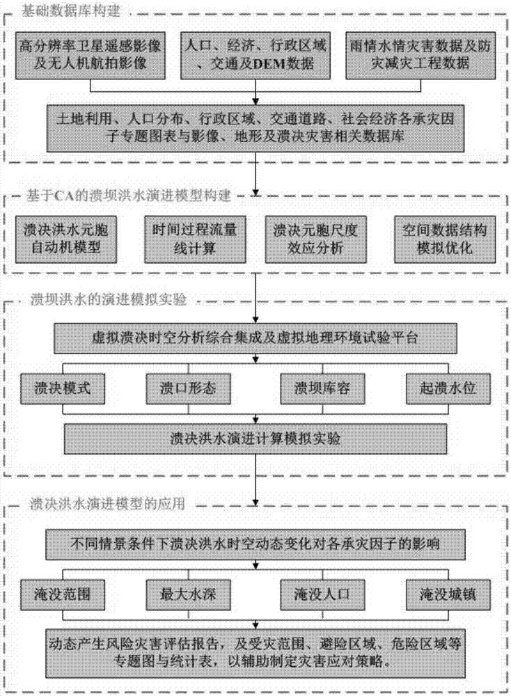
[0051] Such as figure 1 As shown, the construction of the basic database is carried out firstly, including: collecting and processing the data related to the analysis area, and forming the thematic chart and related database of the hazard-bearing factors. The data related to the analysis area include high-resolution satellite remote sensing images and wireless Human-machine aerial images, population, economy, administrative area, traffic, digital elevation model (Digital Elevation Model, DEM) data, rain and water disaster data, the disaster risk factors include land use, population distribution, administrative area, traffic road and social economy.

[0052] Secondly, establish a burst flood evolution model based on cellular automata, including:

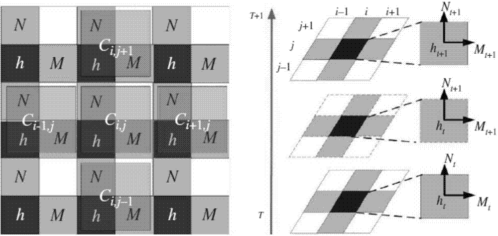
[0053] S1, building a two-dimensional cellular automata simulation model, the two dimensions of the two-dimensional cellular automata simulation model are respectively x, y, including:

[0054] Determine the state of the cell; estab...


PUM


Abstract

The invention belongs to the field of virtual geographical environment research of a geographic information system, particularly relates to an outburst flood routing simulation and analysis technique, and relates to a cellular automata based rapid outburst flood routing simulation and analysis method. By the method, the problem that an error between a final numerical analysis result and actual water regimen is large due to randomness of cellular scale partitioning at present can be solved; meanwhile, accurate and rapid comprehensive simulation and analysis can be performed on dam-break flood routing and influences by means of reasonable setting of a cellular neighborhood range and combination of spatial analysis capacity of a GIS (geographic information system) and spatial-temporal modeling capacity of cellular automata simulation. The method includes construction of a two-dimensional cellular automata simulation model, optimization of a cellular spatial data structure and virtual geographical environment based visual simulation and analysis.

Description

technical field [0001] The invention belongs to the research field of virtual geographic environment of geographic information system, and in particular relates to the simulation analysis technology of burst flood evolution. Background technique [0002] There are 85,000 reservoirs of various types in my country, and nearly 40,000 of them are in danger of dam failure. In addition, frequent earthquakes, landslides, rainstorms and other natural disasters in recent years have led to the formation of a large number of barrier lakes. Due to the great uncertainty and failure risk in the stability of the barrier lake dam body, how to efficiently analyze and evaluate the failure risk is particularly important. [0003] Due to the suddenness, rapid expansion, short response time, and complex and changeable influencing factors of flood outburst events, high requirements are put forward for the intuitiveness, rapidity, and accuracy of the analysis of the outage development process and...

Claims


Application Information

Patent Timeline
IPC IPC(8): G06F19/00G06F17/50
CPCY02A10/40
Inventor 朱军李毅胡良喜胡亚王金宏张阿丽尹灵芝秦川
Owner SOUTHWEST JIAOTONG UNIV
Why Eureka
Try Eureka