
Ship recognition system and method for UAV aerial images

A technology of aerial imagery and recognition system, which is applied in the field of aerial imagery recognition and can solve problems such as loss of recognition accuracy

Inactive Publication Date: 2016-12-28
TIANJIN UNIV
View PDF3 Cites 0 Cited by
  • Summary
  • Abstract
  • Description
  • Claims
  • Application Information

AI Technical Summary

Problems solved by technology

However, automatic processing often loses the recognition accuracy. How to realize the target recognition and positioning of aerial imagery under the premise of ensuring accuracy has become the primary problem in actual demand.

Method used


Image

  • Ship recognition system and method for UAV aerial images
  • Ship recognition system and method for UAV aerial images
  • Ship recognition system and method for UAV aerial images

Examples


Embodiment Construction

[0083] On the premise of constructing the sea surface template library, the present invention will automatically match the obtained image to be recognized to obtain a high-quality sea surface template, obtain the sea surface seed point, and use this point as the center to perform sea surface growth, and the generated Trimap initializes the grabcut algorithm, Get the final segmentation result. If combined with the longitude and latitude information of the image itself, the calculation and calibration of the longitude and latitude information can also be performed.

[0084] The technical solution of the present invention will be described in detail below in conjunction with the drawings and embodiments.

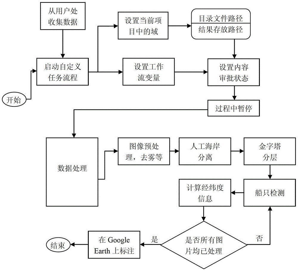
[0085] The specific implementation flow chart of the ship recognition system for UAV aerial images of the present invention is as follows figure 1 shown. Start a custom task process, collect images to be recognized from users, and environment settings of the operating system ...


PUM


Abstract

The invention discloses a ship recognition system and method for unmanned aerial vehicle images. The system includes a sea surface aerial image database, a sea surface template selection module, a background trimap model automatic acquisition module and a background model-based Grabcut algorithm module to construct a sea surface template. Library, build image feature values, use voting method for template selection; design a template matching method, so that the obtained seed points can grow high-quality background, obtain distance threshold parameters through template information, perform region growth, and generate background according to the background mask map Trimap; use Trimap to initialize the background model of the grabcut algorithm, and find the minimum number of iterations that can get the best results. The invention can realize more accurate and automatic recognition of ships, and when a user provides images separated from land and sea, the processing result of the method can be quickly obtained, and the result of ship recognition can be obtained.

Description

technical field [0001] The invention relates to an aerial image recognition technology, in particular to a ship identification method for an aerial image of an unmanned aerial vehicle. Background technique [0002] With the application of UAVs in marine, forestry, natural resource supervision and other fields, the use of UAVs for vessel positioning and fishery activity supervision can not only reduce labor costs and complete high-complexity tasks, but also improve the real-time and maneuverability. According to different tasks, UAVs can mount different aerial photography systems such as synthetic aperture radar systems and high-resolution optical cameras. Compared with satellite remote sensing images, UAV aerial photography has the following advantages: good time phase, high resolution, high definition, large stereo tangential overlap, strong autonomy and can be measured. [0003] However, the number of images acquired by a UAV flight is large, the amount of image data is ...

Claims


Application Information

Patent Timeline
Patent Type & Authority Patents(China)
IPC IPC(8): G06K9/64G06K9/00G06T7/00
Inventor 徐超张东萍冯志勇王建荣
Owner TIANJIN UNIV
Learn More