Automatic registering method of remote-sensing image

A remote sensing image and automatic registration technology, applied in the field of image processing, can solve the problems of uneven distribution of feature points, low registration accuracy, and low accuracy of pixel correction, so as to overcome the problem of incomplete correspondence of ground objects and improve registration The effect of improving accuracy and registration accuracy

Inactive Publication Date: 2014-01-29
SATELLITE SURVEYING & MAPPING APPL CENTSASMAC NAT ADMINISTATION OF SURVEYING MAPPING & GEOINFORMATION OF CHINANASG
View PDF4 Cites 24 Cited by
  • Summary
  • Abstract
  • Description
  • Claims
  • Application Information

AI Technical Summary

Problems solved by technology

[0004] Although the image to be registered is registered in the related art, because the distribution of feature points in the image to be registered and the reference image is not uniform, the selected point of the same name is not uniform, and it is located near the point of the same name when performing quadratic polynomial correction. The pixels with the same name will have a higher correction accuracy, and the farther the pixel is from the same name point, the lower the correction accuracy will be.
Therefore, the use of regular grids to divide sub-image block pairs will result in lower uniformity of homonymous points in the divided sub-image blocks, resulting in lower registration accuracy in areas where homonymous points are sparsely distributed, and reducing the registration accuracy of the overall image. Accuracy; and because the registration may produce deformation of the edge area of ​​the sub-image block, it will lead to incomplete correspondence of the sub-image block's ground features, further reducing the registration accuracy of the image

Method used


Image

  • Automatic registering method of remote-sensing image
  • Automatic registering method of remote-sensing image
  • Automatic registering method of remote-sensing image

Examples


Embodiment Construction

[0024] Terms in the present invention are explained as follows:

[0025] Reference Image: The reference image used as the matching reference during image matching.

[0026] Image to be registered: During image matching, the image coordinates need to be corrected to the image to be matched in the coordinate system based on the reference image.

[0027] Feature point: A feature point is a point that reflects the type of ground object or the geographical distribution characteristics of a region. It has accurate geographic location and clear geographic attributes and meanings on the map. It generally includes: ① independent feature points; ② inflection points or inflection points of the boundary lines of linear elements or area elements; ③ intersection points between various line elements and area element edges, etc. Through these points, the topological relationship between different geographical types is established in the geographic information system.

[0028] Points with t...


PUM


Abstract

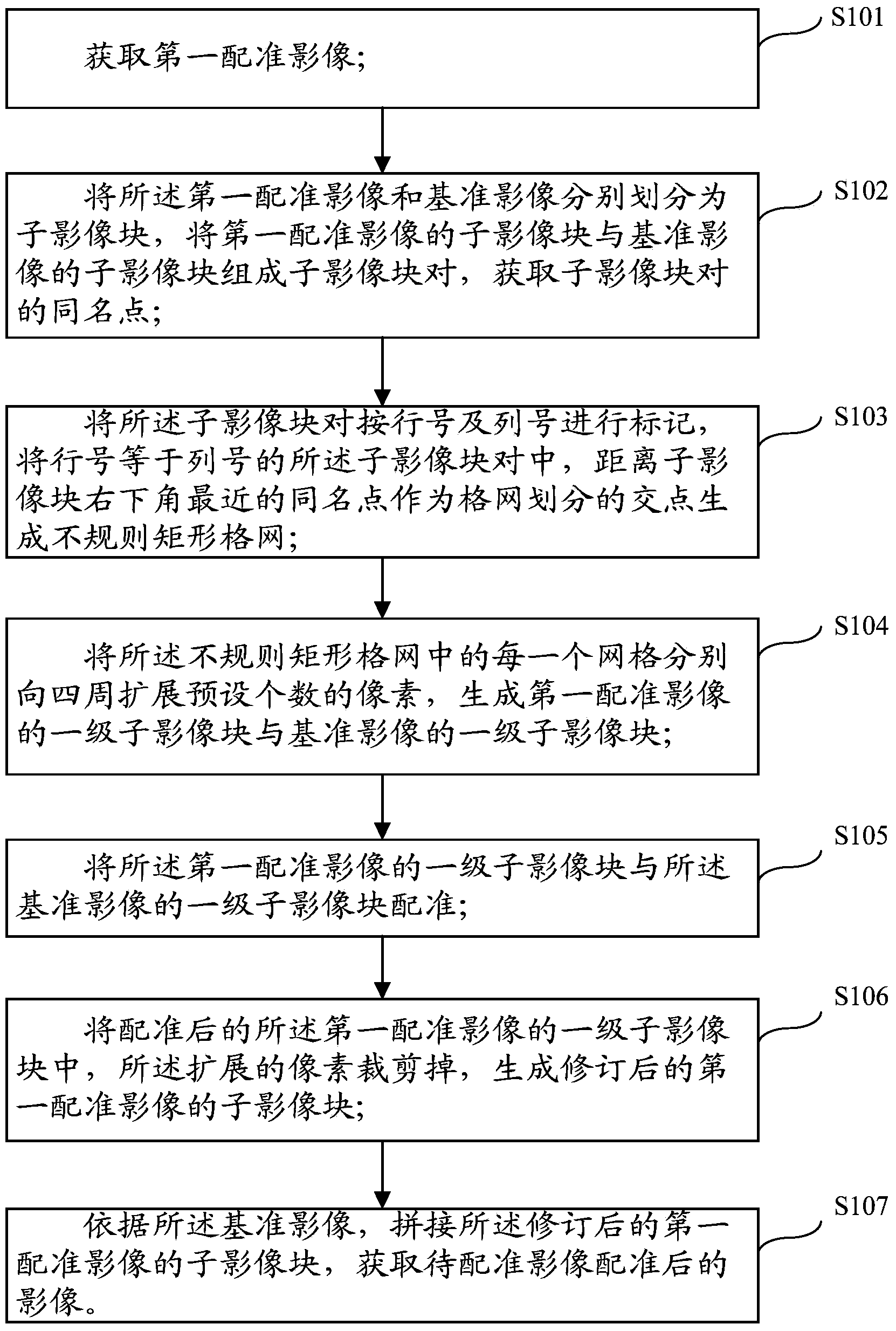
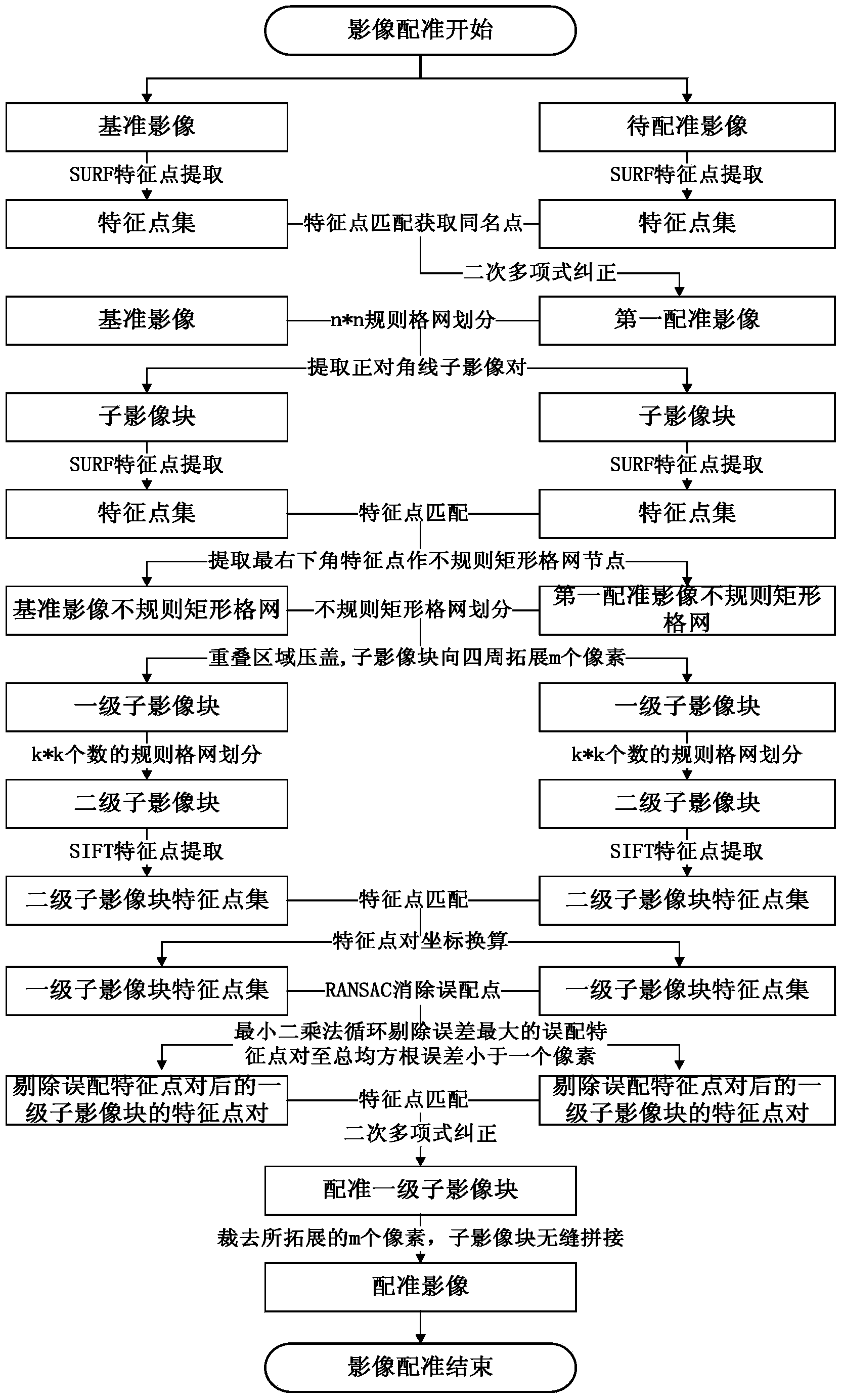
The invention relates to an automatic registering method of a remote-sensing image. A first registering image after an image to be registered is registered and a benchmark image are divided according to a regular grid with the preset size, and divided sub-image blocks are aligned. Identical points closest to the lower right corners of the sub-image blocks serve as intersection points for grid division, and irregular rectangular grids are generated. Evenness of the identical points is improved, the registering precision of areas where the identical points are sparsely distributed is improved, and therefore the registering precision of the whole image is improved. The irregular rectangular grids are then expanded to generate first-class sub-image blocks, and registering is performed on the sub-image blocks. The first-class sub-image blocks which are registered are cut, and expanded portions of the first-class sub-image blocks generate sub-image blocks of the revised first registered image. Finally, marginal areas which are possibly deformed after registering are cut, and the sub-image blocks of the first registered image after splicing and revising are spliced, and the registered image is obtained. The problem that the sub-image blocks are in incomplete correspondence with objects due to local deformation of the image is solved, and the registering precision of the image is further improved.

Description

technical field [0001] The invention relates to the field of image processing, in particular to an automatic registration method for remote sensing images. Background technique [0002] Image registration is one of the most important links in image processing, information integration and analysis. It is also the basis and important step of image stitching, image fusion, and super-resolution reconstruction technologies. It is used in computer vision, satellite image processing, and medical diagnosis and treatment. There are a wide range of applications in the field. High-precision image registration can make subsequent processing more efficient and the processing results better. Taking satellite imagery as an example, image registration is to select the reference image and the image to be registered in two or more multi-source images of the same scene, refer to the geometric position relationship between the reference image and the object, and use the predetermined matching ...

Claims


Application Information

Patent Timeline
Patent Type & Authority Applications(China)
IPC IPC(8): G06T7/00
Inventor 冯先光高崟雷兵徐畅刘克
Owner SATELLITE SURVEYING & MAPPING APPL CENTSASMAC NAT ADMINISTATION OF SURVEYING MAPPING & GEOINFORMATION OF CHINANASG
Why Eureka
Try Eureka