Method for obtaining exterior orientation elements of aerial photograph

A technology of external orientation elements and photos, which is used in the interpretation of photos, satellite radio beacon positioning systems, and navigation through velocity/acceleration measurement, etc., and can solve the problems of low accuracy and large errors of external orientation elements in aerial photos. , to achieve the effect of improving accuracy, small error and high precision

Active Publication Date: 2014-02-05
WUHAN UNMAP REMOTE SENSING TECH CO LTD
View PDF7 Cites 22 Cited by
  • Summary
  • Abstract
  • Description
  • Claims
  • Application Information

AI Technical Summary

Problems solved by technology

[0008] When implementing the above method, the inventors found that there are at least the following problems in the prior art: the outer orientation elements of the aerial photos obtained by the above method, using the position of the GPS antenna phase center and the attitude information of the IMU, are measured on the international general ground The outer orientation elements calculated in the coordinate system, the calculated coordinates are the coordinates of the ground points corresponding to the aerial photos in the international common coordinate system, and the results required for photogramm

Method used


Image

  • Method for obtaining exterior orientation elements of aerial photograph
  • Method for obtaining exterior orientation elements of aerial photograph
  • Method for obtaining exterior orientation elements of aerial photograph

Examples


Embodiment Construction

[0023] Glossary:

[0024] Photogrammetry: It is a science and technology to obtain the geometric information and physical information of the object by photographing, measuring and interpreting the image obtained by the object under study.

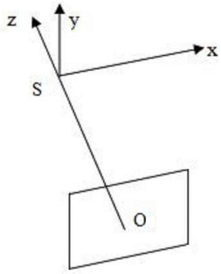
[0025] Outer orientation element: also known as the outer orientation element of the photo. Basic data for determining the geometric relationship of the photographic beam at the object space. It is used to represent the spatial position of the photographic light beam at the moment of photography, and there are 6 outer orientation elements, including three line elements and three corner elements. The three line elements refer to the coordinates of the photography center S in the ground measurement coordinate system at the moment of photography, generally used (X S ,Y S ,Z S )express. The three corner elements describe the spatial attitude parameters of the photo at the moment of photography, that is, the three deflection angles from the...


PUM


Abstract

The invention relates to a method for obtaining exterior orientation elements of an aerial photograph. The method comprises the first step of performing ellipsoid correction and projection on a rotation matrix formed by first included angle data obtained in advance to obtain a rotation matrix formed by second included angle data, the second step of obtaining the second included angle data according to the rotation matrix formed by the second included angle data and using the second included angle data as three angle elements of the exterior orientation elements, the third step of obtaining first spatial offset, the fourth step of converting the first spatial offset to second spatial offset through the rotation matrix formed by the second included angle data, the fifth step of obtaining the coordinates of a GPS antenna phase center in a preset national ground survey coordinate system, and the sixth step of converting the coordinates of the GPS antenna phase center in the preset national ground survey coordinate system to the coordinates of a photographing center in the preset national ground survey coordinate system through the second spatial offset and using the coordinates of the photographing center in the preset national ground survey coordinate system as three line elements of the exterior orientation elements. The method is small in error and capable of obtaining the high-precision exterior orientation elements.

Description

technical field [0001] The present invention relates to the field of photogrammetry, in particular to a method for acquiring outer orientation elements of aerial photographs. Background technique [0002] The outer orientation element is the basic data to determine the geometric relationship of the photographic beam on the object side, and is used to characterize the spatial position of the photographic beam at the moment of photography. The outer orientation elements specifically include: three corner elements, which are used to express the spatial posture of the image plane; and three straight line elements, which are used to describe the spatial coordinate value of the photography center. [0003] The exterior orientation elements of aerial photos can be used to improve the matching efficiency of aerial photos. Because when matching aerial photos, it is necessary to compare two aerial photos (generally referred to as left and right). image to find the point with the sam...

Claims


Application Information

Patent Timeline
IPC IPC(8): G01S19/42G01C21/16
CPCG01C11/08
Inventor 李英成丁晓波刘沛刘飞李会娟
Owner WUHAN UNMAP REMOTE SENSING TECH CO LTD
Why Eureka
Try Eureka