GPS/INS integrated navigation system clock error correction method based on satellite PPS

An integrated navigation system and clock error technology, applied in the field of integrated navigation, can solve the problems of not considering the frequency accuracy and stability of the INS system, the difficulty of realizing high-precision navigation, and the failure to further improve the synchronization accuracy, etc., to achieve high navigation and positioning accuracy Effect

Active Publication Date: 2014-02-12
BEIJING AUTOMATION CONTROL EQUIP INST
View PDF3 Cites 3 Cited by
  • Summary
  • Abstract
  • Description
  • Claims
  • Application Information

AI Technical Summary

Problems solved by technology

In the usual system design, only the GPS and INS clocks are synchronized to the INS update cycle (such as 5ms), without further improving the synchronization accuracy, and at the same time, the accuracy and stability of the INS system frequency standard are not considered, so it is difficult to achieve high-precision navigation

Method used


Image

  • GPS/INS integrated navigation system clock error correction method based on satellite PPS
  • GPS/INS integrated navigation system clock error correction method based on satellite PPS

Examples


Embodiment Construction

[0023] A method for correcting the clock error of the satellite PPS-based GPS / INS integrated navigation system of the present invention will be described in detail below in conjunction with the accompanying drawings and embodiments.

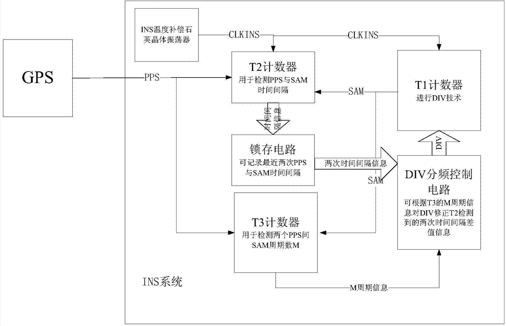
[0024] Such as figure 1 Shown, a kind of GPS / INS integrated navigation system clock error correction method based on satellite PPS of the present invention comprises the following steps:

[0025] step 1

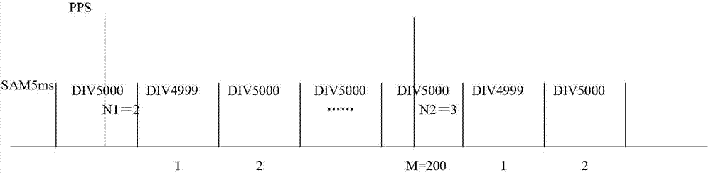
[0026] The counter T1 is used to count the CLKINS clock signal of the INS temperature-compensated quartz crystal oscillator for DIV counting. Whenever the CLKINS clock signal of a INS is received, the counter T1 generates a SAM signal, that is, the period of the SAM signal is a CLKINS clock signal period.

[0027] step 2

[0028] Such as figure 2 As shown, the counter T2 receives the CLKINS clock signal of the INS temperature compensated quartz crystal oscillator, the PPS signal sent by the GPS and the SAM signal generated by the counter T1,...


PUM


Abstract

The invention belongs to the technical field of integrated navigation, and particularly relates to a GPS/INS integrated navigation system clock error correction method based on satellite PPS. According to the method, an INS clock is corrected by means of a GPS atomic clock, the technical problem that a GPS/INS integrated navigation system in the prior art has clock errors, and short-term stability of INS time and long-term stability of GPS time are combined, so that the integrated system obtains higher navigation positioning precision.

Description

technical field [0001] The invention belongs to the technical field of integrated navigation, in particular to a method for correcting the clock error of a GPS / INS integrated navigation system based on satellite PPS. Background technique [0002] The GPS satellite receiver is an instrument that receives the global positioning system satellite signal, determines the ground space position, and receives the high-precision (atomic clock level) time standard provided by the GPS satellite for time service. The satellite PPS signal is a synchronous second pulse signal, and its rising edge time is often used to indicate the whole second time and the corresponding international coordinated time UTC. The GPS system can provide high-precision three-dimensional position, three-dimensional velocity and time navigation information in real time, and it is widely used in many fields. Human and non-human interference, external signal occlusion and other environmental impacts. [0003] The ...

Claims


Application Information

Patent Timeline
Patent Type & Authority Applications(China)
IPC IPC(8): G01S19/49G01C25/00
CPCG01C21/165G01C25/00G01S19/49
Inventor 王宁何杰张伟彬赵振涌汪辉李婷婷
Owner BEIJING AUTOMATION CONTROL EQUIP INST
Why Eureka
Try Eureka