Method for achieving network real-time kinematic positioning based on GNSS multi-frequency data and CORS

A network real-time dynamic and data technology, applied in satellite radio beacon positioning systems, measurement devices, instruments, etc., can solve the problems affecting the accuracy of atmospheric error models, low success rate, and long time.

Active Publication Date: 2014-02-26
SHANGHAI HUACE NAVIGATION TECH
View PDF2 Cites 21 Cited by
  • Summary
  • Abstract
  • Description
  • Claims
  • Application Information

AI Technical Summary

Problems solved by technology

[0003] Before BDS (BeiDou Navigation Satellite System, Beidou Satellite Navigation System) was put into use, CORS system reference station receivers were mostly GPS (Global position system, global satellite navigation system) + GLONASS (Glonass Navigation System) dual-satellite dual-frequency receiver Therefore, the reference station network baseline ambiguity fixation and atmospheric error model construction are also based on GPS / GLONASS dual-frequency data for calculation, and the GPS data with high pseudo-range quality is mainly used, and the GLONASS data with low pseudo-range quality As a supplement, using this method to solve generally takes a long time, and the success rate of the fixed ambiguity result is easily affected by the pseudorange accuracy, and the longer the baseline length, the lower the fixed success rate, which in turn affects the accuracy of the atmospheric error model. accuracy

Method used


Image

  • Method for achieving network real-time kinematic positioning based on GNSS multi-frequency data and CORS
  • Method for achieving network real-time kinematic positioning based on GNSS multi-frequency data and CORS
  • Method for achieving network real-time kinematic positioning based on GNSS multi-frequency data and CORS

Examples


Embodiment Construction

[0048] In order to describe the technical content of the present invention more clearly, further description will be given below in conjunction with specific embodiments.

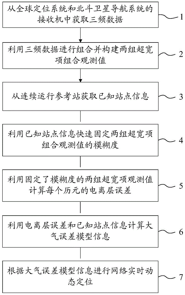
[0049] The present invention creates a method for constructing an atmospheric error model using GPS / BDS tri-frequency data and GLONASS dual-frequency data. The present invention uses GPS / BDS tri-frequency data and GLONASS dual-frequency data to construct an atmospheric error model, mainly through the following technical solutions accomplish:

[0050] 1. First use the tri-frequency data of GPS / BDS for combined calculation, and solve the atmospheric error model of GPS / BDS.

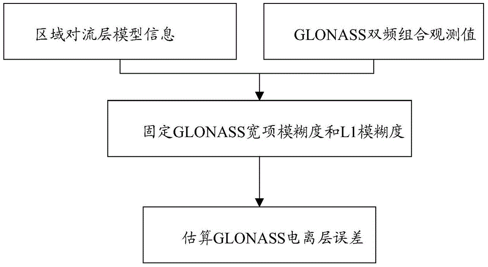
[0051] 2. Then use the known tropospheric model information to solve the GLONASS carrier phase ambiguity information and estimate the GLONASS ionospheric error.

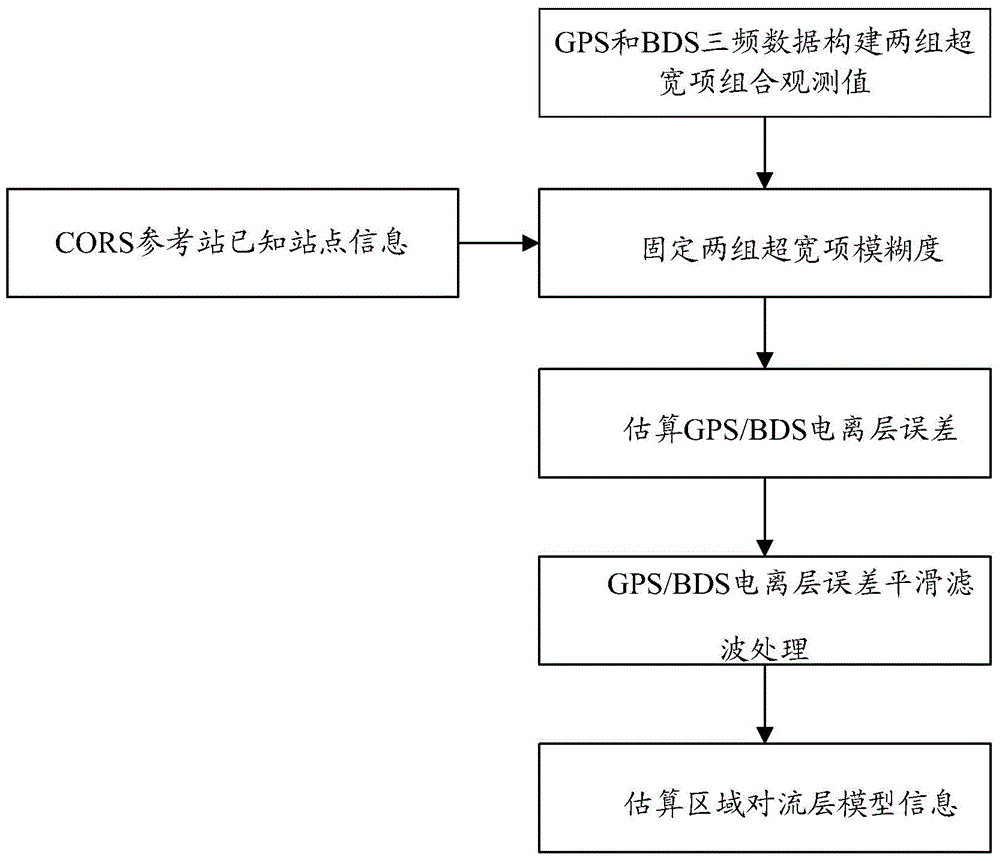
[0052] Among them, such as figure 2 As shown, the calculation of the GPS / BDS atmospheric error model is realized through the following scheme:

[0053] 1. Combining GPS and ...


PUM


Abstract

The invention relates to a method for achieving network real-time kinematic positioning based on GNSS multi-frequency data and CORS. The method comprises the steps that three-frequency data are acquired from a receiver of a global positioning system and a receiver of a Beidou satellite navigation system; the three-frequency data are combined, and two sets of ultra-wide item combination observation values are constructed; known site information is acquired from the CORS; the ambiguity of the ultra-wide item combination observation values is fast fixed through the known site information; the ionized layer error of each epoch is calculated through the ultra-wide item combination observation values with the ambiguity fixed; atmosphere error model information is calculated through the ionized layer errors and the known site information; the network real-time kinematic positioning is carried out according to the atmosphere error model information. According to the method for achieving the network real-time kinematic positioning based on the GNSS multi-frequency data and the CORS, a complex ambiguity search can be avoided, and therefore an atmosphere error model is fast constructed, a reliable data source is provided for the release of network RTK differential information, and the method is suitable for large-scale popularization and application.

Description

technical field [0001] The invention relates to the field of GNSS ground-based augmentation systems, in particular to the field of real-time dynamic positioning using GNSS system multi-frequency data, and specifically refers to a method for realizing network real-time dynamic positioning based on GNSS multi-frequency data and CORS. Background technique [0002] At the beginning of this century, Continuously Operating Reference Stations (CORS, Continuously operating reference stations) were successively established, resulting in the network RTK technology that relies on the reference station network for RTK (Real-time kinematic, real-time dynamic measurement) positioning, and gradually replaced the traditional 1+ Mode 1 RTK positioning has become the mainstream RTK measurement mode. Network RTK technology relies on the real-time data stream of the continuously operating reference stations permanently built in the region, constructs a triangulation network for regional atmosph...

Claims


Application Information

Patent Timeline
Patent Type & Authority Applications(China)
IPC IPC(8): G01S19/44G01S19/07
CPCG01S19/07G01S19/425G01S19/44
Inventor 袁本银刘若尘王杰俊高鹏丽孙慧敏吴大钢
Owner SHANGHAI HUACE NAVIGATION TECH
Why Eureka
Try Eureka